Our Blogs

All Blogs

Camping

Safety in Travel: Tips for a Secure  Adventure

Camping

Safety in Travel: Tips for a Secure Adventure

Travel opens up a world of discovery, but ensuring your safety is essential to making the experience truly enjoyable. Whether you're trekking through the Himalayas, exploring new cities, or heading off on a solo backpacking trip, taking safety seriously will protect you from unnecessary risks and allow for a smoother journey. Any kind of travel cannot be successful without safety. Preparation should begin 2-3 months in advance, focusing on physical conditioning and securing specialized travel insurance for travel, trekking, and expeditions in the Himalayas. It requires careful preparation, primarily focusing on altitude acclimatization, physical fitness, proper gear, and hiring experienced local guides. The most important update in 2026, for Himalayan adventures or travels, is governed by strict regulations and essential physiological precautions. In 2026, all foreign trekkers are required to be accompanied by a government-registered guide for popular treks or expeditions. Solo expeditions on high peaks like 8,000m are strictly prohibited. Without a certified guide, you cannot obtain a TIMS (Trekking Information Management System) card to ensure trekkers' safety and local economic support.

Start by thoroughly researching your destination. Understand local laws, customs, emergency contacts, and health requirements. Knowing what to expect can help you avoid culture shock or unintentional offenses. Before departure, share your travel plans with a trusted friend or family member and keep in touch regularly.

Insurance is the most important thing for travelling to make sure travelers or trekkers feel safe, confident, and secure. Before the trek or expedition begins, you must make sure your travel insurance explicitly covers high altitude trekking (up to 6,000 meters) and emergency helicopter evacuation, as standard policies often exclude these.

When packing, include important safety items like a first-aid kit, water purification tablets, a headlamp, an extra phone charger, and essential medications. Make digital and physical copies of key documents such as your passport, visa, insurance, and emergency contacts. If you're heading into the wilderness or high altitudes, go with experienced guides and choose licensed operators. Follow proper acclimatization routines to prevent altitude sickness and always listen to your body. Dress in layers, stay hydrated, and carry enough food and water. During the trekking and expeditions in the Himalayas, proper gear plays an important role, and proper gear is your life support system. Never wear cotton. Cotton traps sweat and freezes easily, and it leads to hypothermia.

  • Sunglasses/ Goggles
  • Headlamp
  • Warm hat
  • Face mask
  • Neck Gaiter
  • Base layer top
  • Mid-layer fleece or wool Jacket
  • Insulated Down Jacket
  • Waterproof and Windproof Jacket
  • Liner or Insulated outer Gloves
  • Base layer and Trekking pants
  • Waterproof or insulated pants
  • Trekking Socks
  • Trekking or Mountaineering Boots
  • Gaiters and camp shoes
  • A space blanket to reflect 90% of body heat
  • A whistle to sound travels further than a voice in mountain winds.
  • A power bank to keep the batteries of the phone. In high altitudes, cold kills the phone battery.
  • A UV ray's glasses for eye safety to prevent snow blindness.
  • A high-performance oxygen cylinder that increases stamina and helps to prevent life-threatening altitude sickness.  A high-altitude mask features a rigid external frame for stability, an oxygen reservoir protected from wind, and exhalation values designed to prevent freezing in sub-zero temperatures.
  • Climbing boots
  • Crampons
  • Harnesses
  • Helmets
  • Ice axe
  • Ascender
  • Descender
  • Carabiners
  • Safety Rope
  • Ice screws
  • Sleeping Bag
  • Jacket
  • Down pants
  • Gloves
  • Personal clothing
  • Headlamps

The most challenging part in the Himalayas is human health. Without good physical condition, there is less chance of success. For this, your best survival tool is moving slowly. Hydration is a survival skill for Acute Mountain Sickness (AMS) and exhaustion. Solo trekking is not recommended; use your mandatory guide to perform daily 'SOAP' notes (subjective, objective, assessment, plan). When you ignore a persistent headache or slight nausea is the most dangerous mistake a climber can make. In the Himalayas, the only real cure for altitude sickness is a rapid, controlled descent. Avoid walking alone at night, and be cautious in crowded areas to prevent pickpocketing. Keep valuables close and use anti-theft bags or money belts when necessary. Trust your instincts. If something doesn’t feel right, don’t hesitate to leave or ask for help. 

To prevent such an accident on the way, always stay on the uphill side of the trail when animals pass. In the Himalayan regions, mostly Yaks and mules carry heavy loads, and they can accidentally push off a ledge when you stay on the downhill side. The weather is generally stable in the morning and volatile in the afternoon. Better to aim to reach your destination by 2 pm. Whenever or if a disaster occurs, don't panic immediately. Use your guide's satellite phone or your Garmin InReach to trigger SOS.  Follow your guide and avoid shortcuts. Look out for official trail markers, especially in remote areas. The trails can be slippery and prone to landslides during June-August. Carry sufficient cash and essentials, as many trekking regions lack ATMs or card payment facilities. Carry snacks, energy bars, and water purification tablets for remote areas.

Lastly, always purchase comprehensive travel insurance that covers medical emergencies, evacuations, and cancellations. Safety is not about avoiding adventure; it's about preparing wisely and traveling responsibly. With a little foresight and awareness, you can explore the world with confidence and peace of mind.


Himalaya King

 2025-06-18

Trekking

Trek

Trekking

Trek

Trekking is one of the most rewarding ways to explore the natural world. Unlike quick sightseeing trips, trekking allows you to immerse yourself in the environment, culture, and rhythm of local life.

It combines physical challenge with breathtaking scenery and often leads to remote and untouched places. Whether you’re hiking through lush forests, crossing high mountain passes, or wandering ancient trails, trekking pushes you to connect deeply with nature. Along the way, you encounter local communities, learn about their traditions, and enjoy fresh, home-cooked meals in cozy teahouses or campsites.

Trekking can be adapted to any fitness level from gentle day hikes to multi-day expeditions at high altitudes. It improves physical health, builds mental strength, and offers a sense of accomplishment as you reach each milestone. Safety is key: proper preparation, suitable gear, and respect for the environment and local customs make every trek enjoyable and secure.

If you’re looking for adventure, cultural experience, and personal growth, trekking is the perfect journey. Lace up your boots, breathe in the fresh air, and step into the world’s natural wonders one trail at a time.

Himalaya King

 2025-06-18

Everything You Need to Know About Everest Base Camp

Trekking

Everything You Need to Know About Everest Base Camp

Few places on Earth carry the same magic as Everest Base Camp. It’s more than a trail or a trek — it’s a walk into the heart of the Himalayas, where mountain life, culture, and pure natural beauty come together. Sitting at 5,364 meters (17,598 feet), Everest Base Camp (often called EBC) marks the starting point for climbers heading toward the summit of Mount Everest. For trekkers, it’s a dream journey — one that tests endurance, rewards effort, and stays with you for a lifetime.

This guide walks you through everything: from preparation and itinerary to the feel of each day on the trail. No fluff — just what you actually need to know before you go.

The Everest Base Camp trek takes place in Khumbu, a region in northeastern Nepal, within Sagarmatha National Park — a UNESCO World Heritage Site.

The journey usually starts with a short but thrilling flight from Kathmandu to Lukla, landing at the famous Tenzing-Hillary Airport. Perched on a steep hillside at about 2,860 meters, this small airstrip is often called one of the most adventurous airports in the world. From there, your two-week walking journey begins.

As you climb higher, you’ll pass through Sherpa villages, suspension bridges lined with prayer flags, ancient monasteries, and forests filled with rhododendrons (in spring). Every step takes you closer to the towering peaks of the Himalayas.

There are two main trekking seasons for EBC:

1. Spring (March–May) – The weather is mild, rhododendrons bloom, and the visibility is usually good. Climbers preparing for Everest expeditions fill the base camp during these months.

2. Autumn (September–November) – Clear skies, crisp air, and excellent views make this the most popular time. The monsoon has just ended, leaving behind dust-free trails and bright, blue skies.

Winter (December–February) brings extreme cold and heavy snow at higher elevations. The monsoon season (June–August) makes trails muddy and clouds hide the mountains.

Life on the trek follows a simple rhythm — wake up early, walk for several hours, stop for lunch, and reach the next village by afternoon. Evenings are quiet. You’ll eat dinner in a warm dining room, chat with other trekkers, and go to bed early.

At lower altitudes, the trail passes through green valleys and villages surrounded by terraced fields. Higher up, it turns rocky and barren. The air thins, the temperature drops, and every step starts to feel heavier. But the views get better every day — Ama Dablam, Lhotse, Nuptse, and finally, Everest itself.

A typical EBC trek takes around 12–14 days, including acclimatization stops.

Here’s what the route usually looks like:

A short flight (about 30 minutes) lands you at Lukla. After breakfast, you start walking toward Phakding. It’s an easy day with gentle descents.

You cross several suspension bridges and follow the Dudh Koshi River. The final climb to Namche is steep and tiring but rewarding — Namche is the largest Sherpa town, full of bakeries, shops, and cozy lodges.

You’ll spend an extra night here to adjust to the altitude. Take short hikes to Everest View Hotel or Khumjung village. You’ll also visit the local museum to learn about Sherpa culture.

The trail climbs gently and offers stunning views of Ama Dablam and Everest. Tengboche is known for its beautiful monastery, where monks chant prayers every evening.

You descend through forests, cross the Imja Khola river, and climb up to Pangboche and Dingboche. The air is thinner now. Nights are cold.

Another rest day to adapt. A short hike to Nagarjun Hill gives panoramic views of Makalu and Island Peak.

The landscape turns stark and rocky. You’ll pass the Everest Memorial, built in honor of climbers who lost their lives on Everest.

This is the big day. After a few hours of trekking, you reach Gorak Shep — the last settlement before EBC. You drop your bags and continue to Everest Base Camp. The glacier landscape feels unreal. You’ll see colorful tents if expeditions are active.

An early morning climb to Kala Patthar gives the best close-up view of Everest. Many say this is the most emotional moment of the trek. After that, you descend to thicker air.

You retrace your steps back, walking easier now that you’re going downhill.

Weather permitting, you’ll fly back to Kathmandu. Most trekkers keep an extra day for delays since Lukla flights depend heavily on weather.

The EBC trek is moderate to challenging. You don’t need climbing skills, but endurance matters. The hardest parts are the altitude and long walking days.

If you can comfortably walk 10–15 km a day for several days and handle steep climbs, you’ll do fine. Just go slow, listen to your body, and take acclimatization seriously.

Altitude sickness can affect anyone, no matter how fit. Common symptoms include headache, nausea, and fatigue.

Tips to prevent it:

  • Gain height slowly — rest every 600–800 meters of elevation.
  • Stay hydrated.
  • Avoid alcohol and smoking.
  • Sleep lower if symptoms get worse.

Carry Diamox or consult your doctor for preventive medication. Many trekkers carry a pulse oximeter to monitor oxygen levels.

You’ll stay in tea houses — simple mountain lodges run by local families. Rooms usually have twin beds, shared bathrooms, and a dining hall with a wood stove.

Menus are surprisingly varied: dal bhat, pasta, fried rice, soups, momos, porridge, and tea. Higher up, food choices shrink and prices rise because everything is carried by porters or yaks.

Electricity and Wi-Fi are available in some places but often cost extra. Bring a power bank.

You’ll need:

  1. Sagarmatha National Park Permit
  2. Local Rural Municipality Permit

The TIMS card has been replaced by local entry permits in some EBC regions, so check current rules before you go.

Costs vary depending on style and comfort:

  • Budget Trek (Tea House, Group): USD 1,200–1,500
  • Mid-Range (Private Guide + Comfort Lodges): USD 1,800–2,500
  • Luxury (Helicopter return, upgraded hotels): USD 3,000+

This includes flights, permits, accommodation, food, guide, and porter services.

Keep it practical and light. Essentials include:

  • Trekking boots and socks
  • Down jacket and warm layers
  • Base layers and fleece
  • Gloves, beanie, scarf
  • Sleeping bag (rated -10°C or below)
  • Trekking poles
  • Sunglasses, sunscreen, lip balm
  • Water bottles and purification tablets
  • Headlamp and spare batteries
  • First aid kit + altitude medication
  • Passport, permits, insurance papers
  • Always have travel insurance that covers high-altitude trekking.
  • Weather delays at Lukla are common. Keep one buffer day.
  • Porters can carry up to 15–20 kg of your luggage — pack smart.
  • Respect local customs: walk clockwise around stupas, ask before photos, and remove shoes in monasteries.
  • Carry cash — there are few ATMs beyond Namche.

The Khumbu region relies heavily on tourism. Your choices matter.

  • Use refillable bottles to reduce plastic waste.
  • Dispose of trash properly.
  • Support local tea houses and guides.
  • Treat porters fairly — they are the heart of the trek.
  • Respect nature and spiritual sites.

The Everest Base Camp trek is more than just reaching a destination. It’s about slowing down, breathing mountain air, and feeling small beneath giants of ice and stone. It’s not easy — but that’s exactly why it’s worth it.

Every step teaches patience, gratitude, and respect for nature. When you finally stand at the foot of Everest, surrounded by prayer flags fluttering in the wind, you’ll understand why people call this trek life-changing — not because of hype, but because of how it makes you feel.

Himalaya King

 2025-10-09

Complete guide to Upper Dolpo Trek 2026

Trekking

Complete guide to Upper Dolpo Trek 2026

Complete guide to Upper Dolpo Trek in 2026

Upper Dolpo Trek 2026 is one of Nepal’s most remote and culturally rich Himalayan adventures. In the generation of a world turned into modern cities, Upper Dolpo remained a safe place of reality. Upper Dolpo is not about the culture; it's about harmony with nature. As the region is very remote, you will find people living their lives as they used to live hundreds of years ago. Located in Karnali province of western Nepal near the Tibetan border, Upper Dolpo offers untouched landscapes, ancient monasteries, high mountain passes above 5,000 meters, and authentic Tibetan Buddhist culture. Dolpo is a high-altitude region where the Tibetan culture stayed. Some part of this region lies in the Shey Phoksundo National Park. This remote region has preserved its Tibetan culture in pure form, making it attractive and special. Upper Dolpo was only opened for tourists at the end of the 1980s, and it is still considered a restricted area.

If you’re planning a long expedition-style trek in 2026, this 26-day Upper Dolpo itinerary provides a realistic and well-acclimatized route for serious trekkers. If you’re looking for one of Nepal’s most remote and culturally preserved trekking regions, Upper Dolpo is the ultimate adventure. Hidden behind high Himalayan passes and restricted area permits, this region offers raw landscapes, ancient monasteries, and untouched Tibetan culture. For 2026, Upper Dolpo remains a dream destination for serious trekkers who want wilderness over crowds. Upper Dolpo lies in western Nepal, bordering Tibet (China). It is a restricted region, requiring special permits and a licensed guide. The area became globally famous after Peter Matthiessen’s book The Snow Leopard, which described the mystical beauty of Dolpo. Upper Dolpo is known as Hidden Shangri-La.

  1. Restricated Area Permit (RAP)
  2. Shey Phoksundo National Park Permit

Day 01: Arrival at Kathmandu 

Day 02: Afternoon flight from Kathmandu to Nepalgunj and transfers to the hotel

Day 03: Early morning flight from Nepalgunj to Juphal and trek to Kageni (2350m,3/5hrs)

Day 04: Trek from Kageni to Rechi (3011m, 6/7hrs)

Day 05: Trek from Rechi to Ringmo Village (Phoksundo Lake) (3641m, 5/6hrs)

Day 06: Trek from Ringmo Village (Phoksundo Lake) to Lakey Dunga (Rugla) (3700m, 5/6hrs)

Day 07: Trek from Lakey Dunga (Rugla) to Nagdalo H.C (4100m, 3/4hrs)

Day 08: Trek from Nagdalo High Camp to Shey Gompa via crossing Nagdalo Pass(5350m) (4343m, 5/6hrs)

Day 09: Shey Gompa (Rest Day)/ Visit to gompa

Day 10: Trek from Shey Gompa to Namgung via crossing Sela pass(5095m) (4360m, 5/6hrs)

Day 11: Trek from Namgung to Saldang (3700m, 3/4hrs)

Day 12: Trek from Saldang to Komagaon (4200m, 4/5hrs)

Day 13: Trek from Komagaon to Shimengaon (3885m, 4/5hrs)

Day 14: Trek from Shimengaon to Tinje village (4110m, 5/6hrs)

Day 15: Trek from Tinje to Yak Kharka (4480m, 5/6hrs)

Day 16: Trek from Yak Kharka to Dho via crossing Chhoila la(5051m) (3945m, 6/7hrs)

Day 17: Rest Day at Dho

Day 18: Trek from Dho to Chap Chu crossing Chan la Pass(5378m) (4320m, 6/7hrs)

Day 19: Trek from Chap Chu to Chharka Bote (4309m, 5/6hrs)

Day 20: Trek from Chharka Bot to Norbulung/ Nulungsumda (4987m, 6/7hrs)

Day 21: Trek from Norbulung/ Nulungsumda to Ghalden Ghuldun (4247m), Crossing Niwala (5120m) and Jungbenla (5550m) passes (4247m, 5/6hrs)

Day 22: Trek from Ghalden Ghuldum to Sangta (3777m, 5/6hrs)

Day 23: Trek from Sangta to Phalyak (2810m, 6hrs) Day 24: Trek from Phalyak to Jomsom (2720m, 4/5hrs)

Day 25: Early morning, fly from Jomsom to Pokhara to Kathmandu (1350m, 25mins)

Day 26: Departure Day

  • The blue jewel of Phoksundo Lake is the color
  • The spiritual heart of Shey Gumba
  • Remote villages like Saldang and Dho Tarap
  • High mountain passes, including Kang La (5,360m)
  • Last enclave of Bon (reality) religion and Tibetan Buddhist culture
  • Part of Shey Phoksundo National Park
  • Tibetan-style house made of stone and wood
  • Stone Mani and pagoda Buddhist stupa and architecture 

This trek was internationally recognized after the publication of The Snow Leopard, which described the mystical beauty of Dolpo.

1. One of Nepal’s Most Remote Treks

Upper Dolpo remains far less crowded than the Everest or Annapurna regions. Due to restricted permits and long duration, only serious trekkers visit this area. 

2. A True Expedition-Style Experience

This is not a short tea-house trek. With high passes above 5,000 meters and limited infrastructure, it feels like a small expedition with real experience of remote areas. This Upper Dolpo is known as a relaxing trek.

3. Strong Tibetan Cultural Influence

The region shares deep historical and religious connections with Tibet. You will experience a traditional lifestyle, stone-built houses, yak caravans, and ancient monasteries.

4. Sacred and Historical Importance

The legendary Shey Gompa is considered spiritually important in Dolpo. The clear, crystal water beauty of Phoksundo Lake is one of the most photographed landscapes in western Nepal.

5. High Mountain Pass Adventure

Crossing Kang La (5,360m) and Sela La (5,094m) makes this trek a little challenging, but the incredibly rewarding view when you are crossing these high passes is worth it.

  • Upper Dolpo preserves traditions that are slowly disappearing in the world.
  • Ancient Monasteries and Spiritual Heritages.
  • Shey Gompa is a centuries-old monastery surrounded by dramatic cliffs and known as a spiritual heart.
  • Bon religion traditions are still practiced in the remote villages of Dolpa.
  • Mani walls (Stone written spells wall), chortens (stupas), and prayer flags along the trail.
  • Unlike commercial trekking regions, rituals and daily life here remain authentic and deeply spiritual.
  • Traditional Villages: Villages such as Saldang, Dho Tarap, and Ringmo reflect Tibetan-style architecture and lifestyle. Farming, yak herding, and seasonal trade are still the main livelihoods.
  • Cultural Isolation: Because Upper Dolpo requires special permits and controlled access, modernization has reached slowly. This makes it one of Nepal’s most culturally preserved trekking destinations.

1. Phoksundo Lake

Phoksundo Lake is famous for its unreal blue jewel color. Shey Phoksubdi Lake is a stolen piece of sky. Surrounded by cliffs and snow-capped peaks, it is considered one of the most beautiful lakes in Nepal. This lake isn't just a filter; to locals, it is a living deity. Shey Phoksundo Lake is the second-largest alpine lake of Nepal.

2. High Himalayan Desert Landscape

Upper Dolpo lies in a rain-shadow area. The terrain resembles the Tibetan plateau, and is dry, dramatic, and wide open.

3. Shey Phoksundo National Park

The trek passes through Shey Phoksundo National Park, where we can see Blue sheep, Himalayan musk deer, Snow leopard (rarely seen), and diverse alpine vegetation. This National park is the largest and the Himalayan national park in Nepal.

4. High Mountain Pass Views

Crossing Kang La and Sela La offers you panoramic Himalayan views and a real sense of remoteness.

Upper Dolpo is classified as challenging to strenuous.

  • Long trekking duration (25–27 days), which is longer than other normal treks.
  • Multiple high passes above 5,000
  • Limited medical facilities due to the restricted area
  • Basic accommodation in remote sections
  • High altitude risk during the trek
  • Experienced trekkers
  • Good physical condition
  • Previous high-altitude trekking experience
  • Strong mental endurance
  • It is not ideal for complete beginners.

Planning before doing something is important. Planning begins with the legal requirement of a Restricted Area Permit (RAP). Our team and the company will handle it. Unlike the Everest or Annapurna regions, you cannot trek the Upper Dolpo region solo or independently. We ensure a minimum of two trekkers per group. Our logistics team manages a team of mules to carry everything, including the North Face Tent, Kitchen Gas, and fresh products. During the trek, camping is necessary, and we manage it. Our schedule includes rest days at Shey Phoksondo Lake to allow your body to adjust to the high altitude air, which can help you during the high pass crossing. Proper planning and preparation are essential for safety and success.

1. Physical Preparation

  • Cardio workouts (running, cycling, hiking)
  • Stair climbing with a backpack
  • Leg strength training
  • Long-distance weekend hikes
  • Focus on stamina rather than speed.

2. Mental Preparation

Upper Dolpo is a remote region, so what we can expect:

  • Limited internet
  • Basic facilities
  • Long walking days
  • Unpredictable weather
  • Mental resilience is as important as physical fitness.

3. Altitude Preparation

  • Maximum elevation reaches 5,360m at Kang La Pass. To reduce altitude sickness risk:
  • Follow a gradual ascent
  • Drink enough water
  • Avoid rushing
  • Take acclimatization days seriously
  1. Base layer T-shirt and pants
  2. Down Jacket
  3. Trekking boots and thermal socks
  4. Sunscreen/ Sunhat, lip balm, and glacier glasses
  5. Sleeping Bag(-20 degree )/ Water purification and water bottle.
  6. Solar charger/ neck gaiters.
  7. A comfortable day pack
  8. wind/waterproof jacket and pants

Upper Dolpo is not just a trek; it is an adventure. Upper Dolpo remains a restricted trekking region, preserving its raw wilderness and traditional lifestyle. Unlike Everest or Annapurna, this region sees fewer trekkers, making it perfect for those seeking solitude and authenticity.  If you’re planning your trekking calendar for 2026, Upper Dolpo stands out because:

Stunning landscapes with the crystal clear lakes, snowcapped peaks, and spiritual heart monasteries.

  • Traditional villages with Tibetan-style architecture and lifestyle
  • Extremely remote and less crowded
  • Strong Tibetan Buddhist culture
  • Dramatic high passes over 5,000m high
  • Unique desert-like Himalayan landscape

The Upper Dolpo is one of  Nepal's most remote places, and rich in culture preserved for many years. It demands careful planning, strong logistics, and an experienced guide. With our company, your journey is handled with responsibility, preparation, and respect for the mountains. We provide highly experienced and certified guides who can handle every emergency, understand the terrain, high passes, and local culture of Dolpo. Their experience allows you to adapt to weather conditions and trail challenges while maintaining care. We provide warm hospitality with comfort so that no one feels discomfort or dissatisfied. We managed good accommodation and planned properly. We focused more on our customers' safety, and we had prepared a proper itinerary for the Upper Dolpo trek.  We focused on proper acclimatization for your safety. We provide medical/ first-aid kits in remote areas where medical access is limited. We provide clear information about permits, logistics, costs, and expectations before the trek begins. With our company, you don't just complete the trek, you experience the true essence of Dolpo. Choosing the right company is more important than choosing for your own safety and trust. We are ready to provide you with quality service during the trek that makes your trip joyful and memorable. We are ready to welcome you for theUpper Dolpo trek in the upcoming season of 2026 and guide you on a journey that will stay with you for a lifetime.

Upper Dolpo is environmentally sensitive and culturally rich. This trek is more than a journey through remote Himalayan landscapes where you can experience untouched nature, ancient Tibetan-influenced culture, architecture, and true wilderness adventure. From the crystal clear waters of Shey Phoksundo Lake to the sacred Gompa and high mountain passes. Every step in Dolpo makes you feel raw, peaceful, and unforgettable.

Himalaya King

 2026-02-27

Complete Guide to Planning your Everest Base Camp Trek

Trekking

Complete Guide to Planning your Everest Base Camp Trek

Complete guide to planning your Everest Basecamp Trek
If you are planning your next trip in the Himalayan region and dreaming of standing in front of the world's highest mountain, Mount Everest, it is the ultimate goal for everyone. Every adventure lover who dreams of reaching near Mt. Everest, the Everest Base Camp Trek is here for you now. Mount Everest is located in the Khumbu Valley of Solukhumbu district. This trek includes hiking and exploring the Sherpa culture in the Himalayas. Everest is known as 'SAGARMATHA' in Nepali, 'CHOMOLUNGMA' in Tibetan, and Sherpa. Mt. Everest is known as the 'Roof of the World.'
Starting the trek from the most beautiful village, Lukla, is known for its stunning landscape and small, high-altitude airport, which offers stunning views of mountains, hills, and valleys. Treks begin along the Dhudhkoshi River, in small Sherpa, Rai, and Tamang villages. Everest Base Camp treks make us realize that nothing is impossible until we do or see it. On the way, you can explore ancient monasteries and their architecture, and experience their culture. From the Base Camp, you can enjoy the panoramic views of Mt. Everest, Lhotse, and Nuptse, etc. The Everest Base Camp trek is the most iconic in 2026. This guide will help you plan every step of your journey from preparation to reaching base camp.

Maximum Altitude: 5,644 m (Kalapatthar view)
Lowest altitude: 464 m Ramechhap Airport
Location: The Himalayan region of Solukhumbu District 
Duration: 14 days 
Difficulty: Intermediate 
Best Season: Spring and Autumn are the popular seasons for trekking
Spring season (March-May)
During the spring season, the weather is more stable. Spring is a popular and safe season for trekking at high altitude. In this season, you can get flight access due to its stable and clear weather. It offers clear and dramatic views of the mountains, hills, and the river. In the spring season, you can enjoy the trek with Rhododendron flowers along the trail. Low risk of natural disaster. Warm and suitable weather for trekkers at high altitude. The spring season has a very low likelihood of cloud bursts, contributing to the panoramic views of the mountains, dry, safe terrains to navigate, and days last longer, giving you precious time to explore the Himalayas without worrying about darkness. 
Autumn season (September-November)
Autumn is a popular season. The temperature remains warm. The skies are clear. During the Autumn Season, you can enjoy the greenery of the forest on the way and take a picture of the peaks. In the middle of Autumn, one of the biggest festivals of Hindus falls in September or October, and you can also enjoy it. Choosing the EBC Trek in autumn is like having a surprise gift from nature.
Winter(December-February) and Summer (June-August) are not recommended. 
During those seasons, the weather changes quickly. High possibility of heavy rainfall with snowfall, and there are high chances of accidents. During those seasons, finding flight tickets is hard. Due to the weather, we don't recommend those trekking seasons to ensure your safety. In winter, the temperature is low, which can bring health issues at high altitudes. Doing trekking in this season is possible, but risky sometimes. 

  • The Everest Base Camp trek is named after the base camp of Mt. Everest  
    Sagarmatha National Park, which is listed as a UNESCO World Heritage Site
  • The Sherpa culture, known for its natural ability to climb high mountains, is rich in culture.
  • Glaciers, lakes, and Rivers along the trail with blooming Rhododendrons.
  • Old architectures and ancient monasteries 
  • You can explore traditional houses and their traditional attire. 
  • On the way to Everest Base Camp, you can try the traditional food of Sherpa, Rai, and Tamang during the festive season.
  • At high altitude, you can see the national bird ( Daphne/ Lhophoporous), which is rare at lower altitudes.
  • Everest Base Camp Trek offers a complete Himalaya experience with a different cultural experience.
  • Unveiling the beauty of Himalayan giants like Mt.  Everest, Nuptse, Lhotse, Kusum Khangaru, Kongde, and others etc.


DAY-1: Arrival in Kathmandu
Day-2: Sightseeing, packing, gear checking
DAY-3: Fly to Lukla and trek to Phakding
DAY-4: Trek to Namche Bazaar from Phakding
DAY-5: Acclimatization day at Namche Bazaar (Hike option)
DAY-6: Trek to Tengboche from Namche Bazaar
DAY-7: Trek to Dingboche from Tengboche
DAY-8: Acclimatization Day (hike to Nangkartshang Peak)
DAY-9: Trek to Lobuche from Dingboche
DAY-10: Trek from Lobuche to Everest Base Camp and return to Gorakshep
DAY-11: Early hiking to Kalapatthar for sunrise view and panoramic view of mountains, then Descent to Pheriche
DAY-12: Descent to Namche Bazaar from Pheriche
DAY-13: Trek to Lukla from Namche Bazaar
DAY-14: Fly back to Kathmandu and farewell

  1. Khumbu Pasang Lhamu Rural Municipality permit
  2. Sagarmatha National Park permit
  3. TIMS card

Sherpa people live in the Himalaya region, part of Nepal, including Solukhumbu. Solukhumbu is known for its natural Himalayan giant including Mt. Everest, which is the highest peak in the world. It is rich in biodiversity and offers a breathtaking landscape. It has a diverse ecosystem range from lush forests of pine and hemlock to alpine. They had been preserving rare species like the snow leopard, the red panda, and the Himalayan tahr, as well as over 200 bird species. It is culturally renowned as the home of the Sherpa people, whose vibrant tradition and Buddhist heritage add to the religious allure. Monasteries, Prayer Flags, and handmade Stone mani walls dot the landscape, reflecting the spiritual connection between people and mountains.

The journey to Everest Base Camp typically begins with a scenic flight from Kathmandu to Lukla airport, which offers scenic views of the terrain, mountains, and Nature. Trek begins from Lukla and each trail, village, mountain, and the people from the lively atmosphere of Namche Bazaar to the peaceful surroundings of Tengboche Gumba (Monastery), the trek offers a perfect balance of adventure and culture. After reaching the Basecamp, trekkers ususally hikes to Kalapatthar for the breathtaking panoramic views of Mt. Everest and other Himalayan giants. The return journey follows the same trail back to Lukla. Daily trekking involves 5-7 hours of walking/hiking on uneven terrain, with steep ascent and descent to Everest Base Camp. 

Proper gear makes you feel comfortable during the trek. Without proper gear, it creates problems during a trek or expedition, so before planning to head to high altitude, checking gear properly is necessary. Proper gear helps you to keep safe and comfortable with confidence on a trek. A well-equipped trekking gear ensures you are prepared for varied terrain and weather. Here you can check essential gear for your upcoming trek. Planning and preparation before going anywhere is the most important thing. 
Gear list needed for Everest Base Camp Trek:

  1. Down Jacket
  2. Loose, comfortable T-shirts or long-sleeved shirts for sun protection
  3. Long trousers and pants
  4. A warm jacket/ fleece pullover
  5. A thermal layer  (Shirt and pants)
  6. Woolen or thermal gloves
  7. Sun Hat and sunglasses
  8. woolen or fleece hat 
  9. cool breathable cotton socks 4-5 pairs
  10. Sandals and flip flops for the tea house
  11. sun block, lip balm, personal toiletries, and a scarf
  12. A comfortable day pack with shoulder straps
  13. Water bottles, trekking poles, and a headlight
  14. Waterproof dry bags

Before trekking, we all need to do preparation for the trek. Without the preparation, we cannot complete our goal. For EBC Trek, you need to be fully prepared physically and mentally so that it doesn't bother you during the trek. Before the trek begins, we are physically and mentally prepared so that we can enjoy nature peacefully and confidently. We have to prepare our mentality with I can do it and I'll do it myself so that we can boost our confidence in every situation of trekking. Before hiking at high altitude, we have to prepare physically by doing some cardio-vascular training, exercise, meditation/yoga, and running. During the trek, we don't have to face difficulty compared to the expedition, but sometimes we face altitude sickness and other issues. To prevent altitude sickness, we need to prepare before we face the difficulty on the trek. We have prepared a well-structured itinerary with a proper acclimatization day over several days. The physical challenges test your strength, while the beauty of the Himalayas rewards your effort at every step.  With good preparation, a steady pace, and proper guidance, helps to most trekkers are able to successfully complete the journey and reach Mount Everest Base Camp.

This trek leads you to the world's highest peak. Forehead of the sky Villages offer a calm, peaceful environment to everyone. When you are up there in Kalapatthar at sunrise and watch Everest, Nuptse, and Lhotse mountains turning into golden glowing mountains in the morning sun. EBC trek is like a miracle, with the natural beauty of the Himalayas, the foothills, and the rivers. As the altitude gains, the more interesting thing awaits you at high altitude. Everest Base Camp Trek is a beginner-friendly trek, and experienced trekkers also love to do trek in the Everest region due to its natural beauty. This trek is the best option for those who dream of witnessing the beauty of the world's highest peak and other Himalayan giants with fewer technical challenges. This trek is like a preparation for a new expedition journey, and it offers a high-altitude experience to the trekkers who dream to do expedition in the upcoming days.   

When it comes to exploring the Himalayas, choosing the right and well-known company is important, as well as choosing the best trek. We are more than just a service provider; we are your trusted partner. Himalayan King Trekking and Expedition is a government-registered and locally trusted company. We, the Himalaya King teams, are pleased to serve you with warm hospitality. We focused on success with safety. Our company's priority is customer safety. We focused on your satisfaction, not just the service. We followed the proper rules during the trek in the restricted and conservation area. Our team is made up of experienced local guides who know the mountains, culture, and the routes better. We provide comfort and safety to our customers. We provide experienced, certified guides with deep Himalayan knowledge to trekkers, so that they can complete their trip safely. Himalayan King combines experience, dedication, and local expertise to give you the best results and manages every situation, even in challenging conditions, smoothly. From your first inquiry to your final departure, we are always there for you. Our team ensures smooth communication, quick responses, and full support throughout your journey. 
The journey to the Everest Base Camp trek is not only about standing close to Mount Everest (Sagarmatha), but it’s a life-changing adventure that combines true Himalayan experience, rich Sherpa culture, and personal accomplishment at high altitude. Whether you choose the classic 14-day route via Lukla or an extended adventure including Gokyo Lakes and Cho La Pass, each option offers a unique perspective of Nepal’s Khumbu region. Many trekkers choose the Everest Base Camp for trekking to experience high altitude trekking with less challenge. Completing this trek brings a deep sense of achievement and a new perspective on nature and life. It is an experience that stays with you, not just as a memory but as your precious time and experience of life.


Himalaya King

 2026-03-24

Top 10 Destination for Scenic trekking in Nepal in 2026

Trekking

Top 10 Destination for Scenic trekking in Nepal in 2026


Nepal is a popular and famous destination for trekking. Natural beauty and cultural beauty attract tourists from different places. Mostly, tourists choose Nepal for the high-altitude hiking with breathtaking views. Nepal is the best choice for those preparing for peak climbing from a beginner level. In Nepal, there are many trekking options with diverse landscapes. Nepal offers all kinds of experiences, from less challenging to highly challenging routes. Nepal is known for being home to the world's highest mountains. In 2026, Nepal will offer better logistics for tourists and will have improved in the tourism sector. Tourists can choose any destination from the Everest Base Camp to the beaten path of Manaslu Tsum Valley. 

Nepal is rich in natural beauty with panoramic views of the highest mountains.
Home to the world's highest peak, Mount Everest.
Wide range of trekking options
Unique and different culture and mountain lifestyle 
Different landscapes with different cultures and lifestyles
If you plan to go trekking in 2026. Here are the top 10 destinations for scenic trekking in Nepal in 2026. 

1) Everest Base Camp Trek
2) Annapurna Basecamp Trek
3) Annapurna Circuit Trek
4) Manaslu Circuit Trek
5) Langtang Valley
6) Gorepani Poonhill trek
7) Gokyo Ri Lake trek
8) Mardi Himal Trek
9) Tilicho Lake Trek
10) Upper Mustang Trek

Everest Base Camp Trek is a famous trek in Nepal. The Everest Base Camp Trek is named after Mount Everest. Mount Everest is the world's highest peak. Many trekkers have a dream of witnessing Mount Everest with their own eyes. This trek offers the most rewarding views of mountains, rivers, and ancient architecture. In the Everest region, mostly people are of the Buddhist religion. People from the Hindu and Christian religions are also there. Along the trail, Rhododendron will welcome you in the spring season. You will trek along the river of the Dudh Koshi to Everest Base Camp. The trek begins through the legendary Sherpa villages like Lukla Bazaar, Namche Bazaar, Tengboche, and others. 

Overview
Location: Solukhumbu District
Maximum Height: 5,545 meters
Durations: 14 Days
Best season: Spring and Autumn seasons
Accommodation Types: Tea houses and Lodges
Category: Moderate
Required Permits: Sagarmatha National Park Entry Permit
Khumbu Pasang Lhamu Rural Municipality Permit

Major Highlights of Everest Base Camp Trek

  • Scenic mountain flight from Kathmandu to Lukla 
  • Witness the breathtaking views of Kalapatthar
  • Close views of the world's highest mountain
  • Walk through a traditional Sherpa village and Cultural exposure
  • Stunning Khumbu Glacier and icefall

The Annapurna Circuit trek is the most iconic in 2026  due to its high passes. The Annapurna trek is one of the most diverse treks, covering everything from subtropical forests to high mountain deserts. The Annapurna circuit trek is known for its dramatic variation in landscapes, cultures, and climates. This legendary route encircles the Annapurna Massif and crosses the Thorong La Pass (5,416m), one of the world’s highest trekking passes. 

Overview
Location: Annapurna region
Maximum altitude: 5416 m
Duration: 17 to 18 days
Best Season: Autumn and spring seasons
Accommodation types: local tea house/hotel
Category: Challenging
Required permit: 
Annapurna Conservation Area Project permit
TIMS Card

Major Highlights of the Annapurna Circuit Trek

  • Cross the thrilling Thorong La Pass (5,416m), which is a major high-altitude achievement
  • Explore the sacred Muktinath Temple, revered by both Hindus and Buddhists
  • Trek through diverse terrain from rice fields to high passes, and waterfalls to alpine deserts
  • Visit Muktinath Temple
  • Views of the Annapurna and Dhaulagiri ranges
  • Rich cultural diversity

Annapurna Base Camp is one of the most iconic, popular, and accessible destinations for trekkers. Annapurna Base Camp trek offers the stunning beauty of nature and the Himalayas. The Annapurna Base Camp Trek is chosen by people because of its accessibility. Annapurna Base Camp is surrounded by towering Himalayan giants like Annapurna I (8,091m) and Machapuchare (Fishtail). This trek offers a perfect blend of alpine landscapes, lush rhododendron forests during spring, and rich Gurung and Magar cultures. Tourists make them more available in 2026 because of their moderate, challenging, and family-friendly trekking destinations. 

Overview
Location: Annapurna region
Maximum altitude: 4,130 m
Duration: 12 days
Accommodation type: Tea house/ Hotel
Category: Mopderate
Best season: Spring and Autumn seasons
Required Permit: Annapurna Conservation Area Project Permit

Major highlights of the Annapurna Basecamp Trek

  • Witness Annapurna I, Machapuchare, Hiunchuli, and Annapurna South towering above
  • Trek through scenic Gurung villages like Ghandruk and Chhomrong
  • Enjoy the vibrant forests of rhododendron, bamboo, and oak
  • 360-degree mountain views at Basecamp
  • Moderate and rewarding trail. 
  • Relax at Jhinu Danda hot springs after a long day of trekking.

Langtang trek is an iconic trek where trekkers can experience rich Buddhist culture and outstanding views of nature. For 2026, Langtang is a popular tourist destination. Langtang trek is ideal for those seeking a shorter yet rewarding Himalayan adventure close to Kathmandu. Langtang offers dramatic views of the mountains and hills. In Langtang, you can explore ancient monasteries. 

Overview 
Location: Langtang region
Maximum Altitude: 4800 m
Duration: 8 days
Accommodation Type: Tea house
Category: Moderate
Best season: Spring and Autumn Seasons
Required permits for Langtang trek:
Langtang National Park Permit
TIMS Card

Major Highlights for Langtang Trek

  • Easy access and near Kathmandu
  • Beautiful Alpine valley views
  • Visit Kyanjin Gompa
  • Diverse Tamang culture
  • The Langtang trek offers Glacier and mountain scenery 

Gorepani Poonhill trek is a famous and short trek. If you are planning to go on a short trek, then Poonhill is the best for a short trek with rewarding views of sunrise and panoramic views of the mountains. In Poonhill, during the spring season, you can enjoy the beautiful scenery of rhododendrons. During that time, the poonhill view point and the route are all covered by Rhododendrons. Enjoying treks with the beautiful landscape along the way to Gorepani. From Gorepani (Poonhill viewpoint), you can enjoy the sunrise views over the Annapurna and Dhaulagiri ranges from Poon Hill (3,210m). 

Overview
Location: Myagdi 
Maximum altitude: 3,210 m
Duration: 4 days
Category: Easy
Accommodation types: Comfortable local tea house
Best Season: Spring and Autumn seasons
Required Permit:
1) Annapurna Conservation Area 
2)TIMS Card 

Major Highlights for Gorepani (Poonhill trek)

  • Panoramic views of the Annapurna and Dhaulagiri ranges
  • Rhododendron forest during the spring season
  • Breathtaking views of sunrise 
  • Short, but an ideal trek for beginners, and those seeking to try other challenging treks.
  • Visit traditional Gurung and Magar villages, known for their hospitality and culture.

Gokyo Ri Trek is an iconic and popular trek that is located in the heart of the Everest region. Gokyo Ri is a glacial valley with pristine turquoise lakes, huge icy glaciers, ridges, and the best panoramic views of the highest snow-capped mountains from Gokyo valley. Gokyo Lake in the Everest region is one of the most pristine turquoise lakes nestled in the northwestern Solukhumbu district. The Gokyo Lakes Trek takes you deep into these untouched and hidden areas of the region. Gokyo Ri Trek offers the perfect blend of glaciers with mountain beauty, high altitude habitat, and an unforgettable experience along the trail. 

Overview
Location: Everest region 
Maximum Altitude: 5357 m
Duration: 10 to 14 days
Category: moderate to challenging
Accommodation Types: Local Tea house
Best season: Spring and Autumn seasons
Required permits: Sagarmatha National Park Entry Permit
Khumbu Pasang Lhamu Rural Municipality Permit

Major Highlights of Gokyo Ri Trek 

  • Glacial valleys with panoramic views of Mount Everest, Lhotse, and Nuptse.
  • High Altitude habitat experience.
  • Explore Sherpa heritage and living culture.
  • Stunning views of crystal clear lakes
  • Peaceful and scenic mountain view

Mardi Himal trek is a short and popular trek in 2026. This trek is perfect for those who want to visit a less crowded trekking area. The Mardi Himal trek offers breathtaking views of Fish Tail Mountain (Machhapuchhre Himal). This trek offers a complete Himalayan adventure and experience for anyone. One of the most special features of the Mardi Himal trek is its ridge walking experience. This trek is suitable for beginners with good physical condition. Compared to popular routes like the EBC Trek or the ABC Trek, the Mardi Himal trek sees fewer trekkers, allowing you to enjoy nature in a calm and quiet setting.

Overview
Location: Annapurna region
Maximum Altitude: 4,500 m
Duration: 4-7 days
Accommodation Type: Tea house/ lodges
Best Season: Spring and Autumn Seasons
Required permit for Mardi Himal Trek:
Annapurna conservations Area Project Permit
TIMS Card

Major Highlights of Mardi Himal Trek 

  • Close views of Machapuvhare (Fishtail) mountain 
  • A less crowded and quieter trail for those who love a quiet trek.
  • Along the way, it offers beautiful forest trails
  • Short and accessible trek for everyone

Tilicho Lake is one of Nepal's most breathtaking and unique high-altitude destinations, located in the Annapurna region. It is a crystal clear and natural lake. Tilicho Lake is situated at 4,919 m high. Tilicho Lake trek is challenging, but it offers an unforgettable adventure through some of the most diverse and changing landscapes in Nepal. This trek is a popular side trip for trekkers in 2026 seeking something more remote and challenging. As you move towards the lake, the scenery shifts from lush green forests and traditional villages to dry, rocky terrain and glacial valleys. This dramatic transition makes the journey visually rich and exciting. 

Overview
Location: Manang region
Maximum altitude: 4,919 m
Duration: 9 days
Difficulty: Moderate to challenging
Accommodation types: Local tea house
Best season: Spring and Autumn seasons
Required permits:
Annapurna Conservation Area Project permit
TIMS card

Major Highlights of the Tilicho Lake Trek

  • This trek is a side trip from the Annapurna Circuit trek
  • It offers dramatic views of glacial lakes at high altitude
  • It offers a diverse landscape and a high-altitude habitat with different cultures
  • This side trip also offers the breathtaking views of the Annapurna range and the Gangapurna mountains with the lake 
  • Unique high altitude experience within a short period

Manaslu Trek is a quiet and less crowded trekking area. Manaslu Trek offers dramatic views of Mount Manaslu. Mount Manaslu is known as the world 8th highest peak. Standing in front of the world's 8th-highest peak makes you more interested in trekking and exploring new things. It is also the best trek for an alternative to the Everest Base Camp and Annapurna Base Camp Trek. While following the route to Larke La Pass, you have to pass through some of the untouched and unspoiled regions of Nepal.

Overview 
Location: Gorkha district
Maximum altitude: 5,106 m 
Duration: 14 days
Accommodation Types: Tea house
Category: Challenging
Best Season: Spring and Autumn seasons
Required permits for Manaslu Trek:
Manaslu Restricted Area Permit
Manaslu Conservation Area Permit
Annapurna Conservation Area Permit
 
Major Highlight of Manaslu Trek

  • Manaslu Trek offers less crowded and peaceful trails 
  • Tibetan-influenced culture
  • Close and breathtaking view of Mount Manaslu (the 8th highest peak)
  • Cross the Larke Pass with full adventure 
  • It offers a remote and authentic experience 

Upper Mustang trek is the most famous trek in 2026, and it is chosen by trekkers. Upper Mustang is a desert region with ancient architecture, house style, and lifestyle. Upper Mustang offers unpredictable things. It offers a desert with a Himalayan experience. Upper Mustang offers living museums of Tibetan culture with ancient monasteries, which are known as Gompas in their language, sky caves, and Buddhist architecture. Upper Mustang is often called the Forbidden Kingdom that lies near the Tibetan border. For trekkers, this is the best time to explore, experience, and learn new things during the Upper Mustang trek. 

Overview
Location: Mustang
Maximum Altitude: 3,810 m
Duration: 17 days
Category: Moderate
Accommodation Type: Hotel/ Lodges
Best season: Spring and Autumn seasons
Required Permits for Upper Mustang Trek:
Mustang Restricted Area Permit
Annapurna Conservation Area Permit

Major Highlights of Upper Mustang Trek

You can experience the desert-like Himalayan landscape in Nepal.
Explore Ancient caves and monasteries that were made in ancient times
Restricted and unique trekking experience
Lo Manthang (Walled city) 
Tibetan culture and its lifestyle in the desert 

  1. Packed the right gear properly
  2. First aid kit for emergencies
  3. Proper acclimatization during the trek
  4. Hire a licensed guide for safety
  5. Avoid trekking during the monsoon and Winter seasons
  6. Stay hydrated during the trek
  7. Carry cash because there is no ATM in a remote area.
  8. Follow local communities' guidance.
  9. Stays on marked trails and avoid shortcut
  10. Carry a power bank or solar charger for backup for the phone 
  11. Listen to your body, don't push too hard

Nepal continues to stand as one of the greatest trekking destinations, offering unmatched diversity from legendary high altitude adventures like Everest Basecamp to culturally rich and scenic routes such as Annapurna Circuit and remote wilderness trails like Upper Mustang. Each destination provides a unique blend of natural beauty, local culture, and personal challenge.
In 2026, trekking in Nepal is expected to be even more accessible and well-managed, with improved infrastructure, better safety awareness, and growing support for sustainable tourism. Whether exploring peaceful trails like Langtang Valley, enjoying panoramic views on shorter routes like Mardi Himal, or taking on remote adventures such as Manaslu Circuit, trekkers will find experiences suited to every level.

Himalaya King

 2026-04-10

North ABC Trek with Panchakunda Lake: The Complete Guide to Nepal's Most Underrated Himalayan Trail

Trekking

North ABC Trek with Panchakunda Lake: The Complete Guide to Nepal's Most Underrated Himalayan Trail

You searched. You scrolled. You opened ten tabs and closed nine of them in frustration. Useful, specific, honest information about the North Annapurna Base Camp trek, the one with Panchakunda Lake, the one that approaches from the north via Humkhola, is almost impossible to find online.

That is not because the trek is bad. It is because the trek is new, deliberately low-key, and almost entirely outside the commercial trekking circuit that dominates Nepal's online content. The trail was officially opened and named in 2019. Most travel websites have never written about it. The few that have copied each other's thin information without ever having walked the route.

The North Annapurna Base Camp trek, almost universally called North ABC, takes you to the northern face of Annapurna I (8,091 m) the same mountain, but approached from the opposite side from the famous southern sanctuary route that draws tens of thousands of trekkers every year.

Historically, this northern approach was used mainly by local herders and expedition teams preparing for Annapurna climbs from the north face. The story of the North ABC dates back 70 years, when French mountaineer Maurice Herzog, along with his team, approached Annapurna from the north side. On June 3, 1950, the successful first ascent became a monumental achievement in mountaineering history. The trail is officially named the Annapurna First Maurice Herzog Trail in his honor.

The route was officially explored and opened in 2019 by the Annapurna Rural Municipality (ARM) group, with support from different trekking associations of Nepal, including TAAN, ACAP, local people, and the Ministry of Tourism.

The critical distinction from the south: you are approaching the world's most dangerous 8,000-meter peak from its northern face the face that faced Herzog and his team in 1950. The views are completely different from the South Annapurna Base Camp, and the route passes through landscapes and villages that south-side trekkers never see.

The Panchakunda Tal is one of the major attractions of the North ABC, which translates to "Five Holy Lakes" in Nepali. In olden times, the lake was locally known as "Dikicho," whereas the current name, "Panchakunda," was used after discovering the appearance of the five ponds by activist Tej Bahadur Gurung.

The trail ascends gradually through alpine meadows and high-altitude pasturelands, passing Busket Mela, a sacred site for locals and pilgrims, before reaching Panchakunda, named after the five holy lakes in the region.

Locals believe Panchakunda is a sacred site, adding a spiritual touch to the journey. The five glacial-fed lakes sit at approximately 4,000–4,050 m, directly below the North ABC. The highest camp of the trek is positioned here, making it the only trekking trail in Nepal with a sacred lake at the highest overnight point.

The lake is just below the base camp, making it the only trekking trail in the country that has a beautiful lake at the top point.

Most people who search for the "Annapurna Base Camp trek" find information about the south side — the famous route through Ghandruk, Chhomrong, Bamboo, and the sanctuary. That is a fundamentally different trek.

Feature North ABC South ABC
Approach direction Northern face of Annapurna I Southern sanctuary
Starting point Humkhola (via Beni) Nayapul or Phedi (via Pokhara)
Duration 5–10 days (flexible) 11–14 days
Altitude of base camp 4,190 m 4,130 m
Teahouse infrastructure Very limited — camping preferred Fully established teahouse network
Trekker numbers Very few — genuine wilderness 30,000–50,000+ per year
Permits ACAP + TIMS ACAP + TIMS
Mountain views North face Annapurna I, Dhaulagiri, Nilgiri, Tilicho Annapurna South, Hiunchuli, Machhapuchhre
Sacred landmark Panchakunda (Five Holy Lakes) Annapurna Sanctuary
Accommodation style Camping / basic tent hotels Full teahouse system

The North ABC is not a variation of the South ABC. It is a completely separate route, completely separate experience, and reaches a completely separate base camp on the same mountain's opposite face.

The trek begins not in Pokhara or Kathmandu but at Humkhola a small trailhead village in the Myagdi District of Gandaki Province, accessible only by jeep along a rough, unpaved track. This access logistics is the first thing that surprises most planners, because it does not resemble the smooth tourist infrastructure of the South ABC.

The Annapurna North Base Camp Trek route begins with a drive from Kathmandu to Beni, followed by an off-road journey to Humkhola.

The standard transport sequence from Kathmandu:

  • Kathmandu → Pokhara: Tourist bus (7–8 hours) or flight (25 minutes). Bus cost: approximately NPR 800–1,200. Flight: approximately USD 80–120.
  • Pokhara → Beni: Local bus (approximately 2–2.5 hours, NPR 250–350) or private jeep
  • Beni → Humkhola: Jeep on rough unpaved track (approximately 2–2.5 hours). Jeep fare approximately NPR 8,000 per vehicle for locals. Booking in advance is advised. Return: Same path down — once you reach Humkhola or earlier, contact the jeep for pickup. Mobile network may be weak, so plan coordination.

The 5-day North Annapurna Base Camp package starts from Pokhara via a 6–7 hour drive to Humkhola (~115 km) through the Annapurna Conservation Area (ACAP), following stone-paved trails through rhododendron forests, Narchyang Waterfall, and Caves past Busket Mela, Sandikharka, and Gupha Phat.

Humkhola elevation: approximately 2,883–2,890 m. This is significantly higher than the South ABC starting points (Nayapul is at 1,070 m), which means you gain altitude faster and the acclimatization profile is more compressed. Plan accordingly.

Stage 1: Humkhola (2,883 m) to Sandikharka / Gufaphant (3,250–3,335 m)

From Humkhola, begin trekking: Humkhola → Sandikharka or Bhusket Mela, depending on your pace. On the way, you will pass waterfalls like Phutphute Jharana (Phutphute Waterfall) and foothills.

This is a bit demanding part you will encounter on the first day, on the way from Hum Khola to Guphaphant, where you will need to ascend frequently. Stone-paved trails cut through subtropical forest before rhododendron and oak take over as you gain altitude. The Phutphute Waterfall is a natural stopping point — photograph it and rest here before continuing.

Approximate walking time: 4–5 hours. Elevation gain: approximately 370–450 m.

Stage 2: Sandikharka / Gufaphant (3,250–3,335 m) to Panchakunda Lake (4,000–4,050 m)

The trail ascends gradually through alpine meadows and high-altitude pasturelands. You pass Busket Mela, a sacred site for locals and pilgrims, before reaching Panchakunda, named after the five holy lakes in the region. This remote and spiritual location offers awe-inspiring views of the Annapurna massif and a unique Himalayan atmosphere.

On the second day, you only gain height gradually, but the route is not that vertical or scary to pass. The trail opens from forest into alpine meadow terrain. Yak pastures begin appearing. The Busket Mela area is a sacred site for the local Magar community — treat it with respect and do not disturb any ritual objects or prayer stones.

Panchakunda Lake at 4,000–4,050 m is your overnight camp. The five glacial-fed lakes reflect the Annapurna massif in still morning light. This is one of the most photographically stunning overnight sites in the Annapurna region — entirely unknown to the South ABC trekking world.

Approximate walking time: 5–6 hours. Elevation gain: approximately 700–750 m.

Stage 3: Panchakunda Lake (4,050 m) to North ABC (4,190 m) and return to Humkhola

Early morning hike from Panchakunda Lake to the Annapurna North Base Camp, taking about 45 minutes at a slow walking pace.

The summit push from Panchakunda to North ABC is remarkably short — less than an hour for most trekkers. The trail is rugged and remote, winding through glacial moraines and rocky ridges. Upon reaching North ABC, enjoy an unforgettable panorama of the Annapurna Sanctuary from the less-traveled northern approach.

The view of Annapurna I's north face from the base camp is direct and dramatic, showcasing the mountain's true scale. You are standing beneath the same face that Herzog's team climbed in 1950 — the face that changed Himalayan mountaineering history. On a clear morning before clouds build (typically before 10 AM), the view is extraordinary.

After the base camp visit, descend all the way to Humkholaa, a long day of 6–7 hours, including the base camp walk. Arrange your jeep pickup from Humkhola to Beni in advance.

The North ABC offers unusual flexibility because the trailhead is accessible by jeep, the route is short, and the core experience (Panchakunda + North ABC) requires only 2–3 days of actual trekking.

Day Stage Altitude Notes
Day 1 Beni → Humkhola (jeep) → Gufaphant 3,335 m 2.5 hr jeep + 4 hr trek
Day 2 Gufaphant → Panchakunda Lake 4,050 m 5–6 hrs, overnight at lake
Day 3 Panchakunda → North ABC → Humkhola → Beni Return 45-min to summit, 6–7 hr descent + jeep

Honest assessment of 3-day: Very fast altitude gain from Beni (830 m) to Panchakunda (4,050 m) in just 2 trekking days is aggressive. Altitude sickness risk is elevated. Suitable only for trekkers with prior high-altitude experience. Not recommended for beginners.

Day Stage Altitude Notes
Day 1 Kathmandu/Pokhara → Beni → Humkhola 2,883 m Transport day, arrive Humkhola by afternoon
Day 2 Humkhola → Sandikharka (acclimatization at lower camp) 3,250 m Short day, 3–4 hrs, rest afternoon
Day 3 Sandikharka → Busket Mela → Panchakunda Lake 4,050 m 5–6 hrs, overnight at lake
Day 4 Summit: Panchakunda → North ABC → return to Humkhola Return Early start 5–6 AM, long day
Day 5 Humkhola → Beni → Pokhara (jeep + bus) Return Transport day
Day Stage Altitude Notes
Day 1 Pokhara → Tatopani hot springs → Beni overnight 830 m Scenic drive, acclimatize low
Day 2 Beni → Humkhola jeep → Narchyang Village 2,200 m Magar homestay if pre-booked
Day 3 Narchyang → Sandikharka → Gufa Phat (cave exploration) 3,335 m Cave visit en route
Day 4 Gufa Phat → Busket Mela (sacred site) → Panchakunda Lake 4,050 m Spiritual significance, lake camp
Day 5 Summit: North ABC → back to Busket Mela 4,190 m Early summit, rest lower camp
Day 6 Busket Mela → Narchyang → Humkhola 2,200 m Cultural village visit on descent
Day 7 Humkhola jeep → Tatopani hot springs → Pokhara Return End with a natural hot spring soak

The 10-day version adds days at Narchyang village for cultural immersion, a visit to the Narchyang caves and waterfall system, a full rest and photography day at Panchakunda Lake, and a side hike along the glacier moraine above North ABC for trekkers wanting more elevation. Suitable for those who want the fullest possible experience of the Myagdi district, the Magar communities, and the upper Miristi Khola valley.

This section answers the question that started this guide — from the trekker who asked about the North ABC in late May and found nothing useful online.

May extends spring trekking but introduces warmer temperatures and increased cloud cover that can limit afternoon visibility. Late May begins showing pre-monsoon characteristics with occasional afternoon showers, though nothing approaching monsoon intensity.

While early and mid-May usually bring ideal trekking weather, conditions start to shift in late May because the pre-monsoon period begins at this time. Expect occasional rainfall, especially in the afternoons, with an increase in humidity in the forest trails. However, these light rainfalls cause no major hurdle in the trek.

For the North ABC specifically, late May has characteristics that differ from the South ABC:

The rain shadow advantage does not apply here. Unlike Upper Mustang, the North ABC route via Humkhola and the Miristi Khola valley is not in a Himalayan rain shadow. It faces monsoon exposure from the south, just like the standard Annapurna region.

But late May is not monsoon. The monsoon typically reaches the Annapurna region in mid-to-late June. Late May is pre-monsoon, a transitional period with:

  • Morning skies: typically clear to partly cloudy
  • Afternoon: increasing cloud build-up, light showers possible after 2–3 PM
  • Night: clear conditions return in most years
  • Temperature at Humkhola (2,883 m): warm during day (15–22°C), cool at night (8–12°C)
  • Temperature at Panchakunda (4,050 m): cool during day (5–12°C), cold at night (−2 to 4°C)
  • Temperature at North ABC (4,190 m): daytime 3–8°C; early morning at summit: −5 to 2°C

This is the specific question most guides ignore. In late May:

  • Below 3,500 m: Trails are fully snow-free. Green, lush forest with wildflowers — rhododendrons are mostly finished at lower elevations but Himalayan wildflowers (primrose, edelweiss, gentian) appear above 3,000 m.
  • Between 3,500 m and 4,000 m (Busket Mela to Panchakunda): Patches of residual snow are possible in shaded gullies and north-facing slopes but trails are generally clear.
  • At Panchakunda (4,050 m): The lake area itself is typically clear by late May, with snow patches on surrounding slopes. The reflections in the lake at late May are among the best of the year — enough snowpack on the peaks above to create dramatic reflections without the trail itself being snow-covered.
  • North ABC (4,190 m): Glacier sections above the base camp still carry significant late-spring snowpack. The approach from Panchakunda to North ABC itself is generally walkable without crampons in late May on a normal year.

Late May specific advice: Start your summit day (Panchakunda → North ABC) as early as possible — 5:00–6:00 AM at the latest. This puts you at base camp by 7:00–7:30 AM with full morning clarity before afternoon clouds build. The early start is even more important in late May than in October, when the post-monsoon clarity persists all morning.

What late May gives you that no other season provides:

The North ABC trek itinerary tips for spring must include timing for rhododendron season. These vibrant blooms transform the landscape from 2,500–3,500 meters elevation. The contrast between crimson rhododendrons and snow-capped peaks creates unparalleled photographic opportunities.

By late May, lower-elevation rhododendrons are finishing, but mid-elevation blooms (2,800–3,500 m) — precisely the Humkhola to Busket Mela corridor — are still active. Fauna are active and moving freely in May due to the mild temperature. Some of the most common wildlife spotted include the Himalayan Thar (wild goat), the Langur monkey, and the musk deer. It is also one of the best times for birdwatching.

Crowds are virtually non-existent in late May even by North ABC standards. This is a trail with very few trekkers at any time — in late May, you may encounter no other foreign trekkers on the route at all.

This is where most guides mislead trekkers with outdated or optimistic information.

Teahouses are available along the North Annapurna Base Camp route, but don't rely on them completely.

Limited accommodation: Only a few basic teahouses are available camping may be required. No telecommunication network: there is no mobile or internet connection in higher areas.

Recently, "tent hotels" have been established along the trail, offering a bed and meals, which is a significant upgrade from pure camping.

The current accommodation reality in 2026:

Humkhola: 1–2 basic teahouses / local guesthouses. Food is simple: dal bhat, noodles, eggs. Accommodation is basic but functional.

Sandikharka / Gufaphant (3,250–3,335 m): 1–2 small teahouses. Not guaranteed to be open outside peak season. Camping as backup is strongly advised.

Busket Mela (3,570 m): Sacred site. Very basic accommodation or camping only.

Panchakunda Lake (4,050 m): Camping is the standard. Only a limited 4 homestays are available in Narchyang Village, need to inform earlier to book. At Panchakunda itself, tent camping is the norm. Some basic tent structures may be available but are not reliable.

North ABC (4,190 m): No accommodation. Day visit only.

Planning implication: The North ABC is a camping trek, not a teahouse trek. Unlike the South ABC where you walk from teahouse to teahouse and book accommodation on the day, the North ABC requires carrying or arranging your tent, a sleeping bag rated to at least −10°C, and cooking supplies (or a cook). Your trekking agency should provide camping equipment as part of the package.

For late May specifically, it is worth confirming with your agency which specific teahouses along the route are currently operating. The few that exist may have inconsistent seasonal schedules.

The North ABC is straightforward in permit terms, significantly simpler than Upper Mustang.

You do not require any special or restricted area permit to reach North ABC. This does not fall under any restricted zone. It is a moderate trek of Annapurna Rural Municipality of Myagdi District in Gandaki Province, Nepal. This trek does not involve technical routes or high-risk zones.

1. Annapurna Conservation Area Permit (ACAP)

  • Cost: NPR 3,000 (~USD 22–25) for foreign nationals; NPR 1,000 for SAARC nationals
  • Obtained: NTB office in Kathmandu (Bhrikutimandap) or Pokhara (Lakeside)
  • Processing: 15 minutes on-site with passport copy and photo

2. TIMS Card (Trekkers' Information Management System)

  • Cost: approximately USD 8–15
  • Obtained: NTB offices or through your trekking agency
  • Note: If you are trekking alone, you are now required to hire a licensed guide to get your TIMS card. Solo trekkers cannot obtain a TIMS card independently under the 2026 guide-mandatory rule.

What is NOT required:

  • Restricted Area Permit (RAP): not needed, North ABC is not a restricted zone
  • NMA climbing permit: not needed, no technical climbing involved
  • Special mountain permit: not needed


The Annapurna North Base Camp Trek is considered a moderate to challenging trek due to its remote location, rugged trails, and high altitude reaching over 4,100 meters. The route involves long trekking days, steep ascents, and basic camping conditions without teahouse facilities. It requires a good level of fitness and prior trekking experience is helpful.

Despite being an easy trek, it is important to note that it is a camping trek. While the route may be relatively easy, the camping aspect means there is a lack of basic facilities along the way. Trekkers should be prepared for limited amenities and adapt to more basic living conditions during the journey.

The honest difficulty assessment: the North ABC is moderate in terms of technical terrain (no glacier crossing, no fixed ropes, no technical sections) but challenging in terms of:

  • Speed of altitude gain (Humkhola to Panchakunda gains ~1,170 m in 2 days)
  • Camping conditions in cold, remote environment
  • Long descent days (Panchakunda to Humkhola is 6–7 hours of knees-and-quads downhill)
  • Limited access to emergency services if altitude sickness develops

Training minimum for late May: Be able to hike 5–7 hours per day with a 10–15 kg pack over varied terrain. Prior altitude experience above 3,000 m is highly beneficial. If this is your first time above 3,500 m, use the 7-day itinerary to allow proper acclimatization.

  • Sleeping bag: rated to at least −10°C (−15°C for late May/early June safety margin)
  • Trekking poles: essential for the long first-day ascent and the long summit-day descent
  • Waterproof layer (jacket and trousers): afternoon rain in late May is possible
  • Warm insulated jacket: nights at Panchakunda drop below 0°C even in late May
  • Headlamp with spare batteries: essential for early morning summit start
  • Sun protection: high-UV at 4,000+ m. SPF 50+ sunscreen, UV-rated sunglasses, lip balm
  • Gaiters: useful for any snow patches above 3,500 m and for wet trail sections
  • Lightweight rain cover for pack: afternoon showers in late May
  • Insect repellent: lower forests have mosquitoes and other insects in late spring

Down jacket, sleeping bag, trekking poles, rain gear, and duffel bags are all available for rental in Pokhara's Lakeside area at reasonable daily rates. Confirm with your agency what camping equipment is included in the package.

At 4,190 m, the North ABC sits well above the 3,000 m threshold where Acute Mountain Sickness (AMS) becomes a meaningful risk for unacclimatized trekkers. The compact itinerary — which compresses significant altitude gain into a short timeframe — makes proper planning essential.

The golden rule: Never ascend more than 400–500 meters of sleeping elevation per day above 3,000 m.

On the standard 5-day itinerary, the move from Sandikharka (3,250 m) to Panchakunda (4,050 m) is an 800 m sleeping elevation gain in a single day — above the recommended limit. This is why the 7-day itinerary (with an extra acclimatization day at around 3,250 m before moving to the lake) is the recommended approach for trekkers without prior Himalayan experience.

Warning signs requiring descent: Severe headache unresponsive to ibuprofen and hydration, loss of coordination, breathlessness at rest, confusion. These are medical emergencies on a remote route with no helicopter access directly to high camp. Descent immediately to Humkhola and then Beni if serious symptoms develop.

Prevention: Stay hydrated (3–4 liters of water daily), ascend slowly, sleep at lower elevation if symptoms appear, consider Diamox (acetazolamide) if prescribed by a doctor before departure.

Mobile network may be weak — plan coordination in advance. Above Humkhola, mobile connectivity becomes unreliable and disappears entirely above 3,500 m. Inform your agency or a contact person of your planned itinerary and exit date before losing signal.

Jeep coordination: Your jeep driver in Beni → Humkhola is your exit plan. Confirm your return pickup date and a contingency contact point at Humkhola before heading up. If plans change on the mountain, you need an alternative communication plan (ask your guide what local radio contact options exist).

River crossings: The Miristi Khola valley has water crossings on the approach trail. In late May, snowmelt increases water flow. Crossings are generally manageable but take care after afternoon rain. Your guide will assess conditions.

Wildlife: The Annapurna Conservation Area is home to snow leopards, Himalayan tahr, musk deer, and red pandas in the upper forests. Respect wildlife protocols — do not approach or feed animals.


Himalaya King

 2026-05-03

Destination Guide

Top 5 Adventure Activities to Try in Nepal

Destination Guide

Top 5 Adventure Activities to Try in Nepal

Step beyond the crowded trails and tourist hotspots to discover Nepal’s secret treasures. This blog highlights serene destinations like Rara Lake, Tsum Valley, Khaptad National Park, and more—ideal for travelers seeking peace, solitude, and authentic local culture away from the mainstream.Avoid overpacking while staying fully prepared. This post lists the most important trekking gear, from moisture-wicking layers and water purifiers to headlamps and energy snacks. Includes tips for high-altitude treks, monsoon trails, and minimalist travel.

 2025-05-12

Discover the Magic of the Everest Region

Destination Guide

Discover the Magic of the Everest Region

The Everest Region, home to the world’s highest peak, is much more than just a mountain t’s a gateway to breathtaking landscapes, rich culture, and unforgettable adventure. Trekking here means walking through rugged trails flanked by towering snow-capped peaks, ancient monasteries, and vibrant Sherpa villages.

From the bustling town of Lukla to the tranquil village of Namche Bazaar, every step immerses you deeper into the unique Sherpa culture and traditions. You’ll experience warm hospitality, taste local delicacies, and witness colorful festivals that light up the mountain communities.

The highlight, of course, is the view of Everest itself. Whether from Tengboche Monastery, Kala Patthar viewpoint, or during your ascent to Everest Base Camp, the majestic sight of Everest inspires awe and humility.

Adventure seekers can also enjoy challenging climbs, glacier walks, and thrilling rafting nearby. The region’s natural beauty and spiritual energy combine to make every trek an extraordinary journey.

Whether you’re a seasoned mountaineer or a first-time trekker, the Everest Region promises an experience that will stay with you forever. Discover its magic and be part of a timeless Himalayan story.

 2023-02-15

The Ultimate Guide to Nepal Trekking & Peak Climbing: Your Complete 2026 Adventure Handbook

Destination Guide

The Ultimate Guide to Nepal Trekking & Peak Climbing: Your Complete 2026 Adventure Handbook

Standing at the crossroads of an epic decision—which Himalayan adventure calls to your soul? Will you trek the legendary trails to Everest Base Camp, circle the dramatic Annapurna massif, or push yourself to summit a 6,000-meter peak with the world's highest mountains as your audience?

Nepal isn't just a destination; it's a transformation waiting to happen. From the bustling streets of Kathmandu to the silent, snow-covered peaks that pierce the sky, this small nation holds more mountain magic per square mile than anywhere else on Earth. Whether you're a first-time trekker or a seasoned mountaineer, Nepal has an adventure perfectly matched to your dreams, fitness level, and available time.

This comprehensive guide brings together everything you need to know about Nepal's most iconic treks and peak climbing expeditions. We'll walk you through each adventure in detail, compare your options, break down costs transparently, and help you make the confident choice that turns your Himalayan dream into reality.

Before we dive into specific treks and climbs, let's talk about why Nepal stands apart as the world's ultimate mountain destination.

Nepal hosts Mount Everest (8,848m), Kanchenjunga (8,586m), Lhotse (8,516m), Makalu (8,485m), Cho Oyu (8,188m), Dhaulagiri (8,167m), Manaslu (8,163m), and Annapurna I (8,091m). No other country on Earth can match this concentration of giant peaks. When you trek or climb in Nepal, you're walking among legends.

The mountains of Nepal aren't empty wilderness—they're home to resilient communities who have lived at these altitudes for centuries. Sherpa, Gurung, Tamang, and Thakali people maintain ancient traditions, Buddhist monasteries, and a way of life intimately connected to the mountains. Your trek becomes a cultural immersion as much as a physical challenge.

From gentle valley walks to technical peak ascents, Nepal offers adventures for everyone. You don't need to be an elite athlete to experience the Himalayas. Well-developed teahouse networks, experienced guides, and carefully designed itineraries make these mountains accessible while maintaining their wild character.

Compared to trekking in Patagonia, the Alps, or other mountain ranges, Nepal offers exceptional value. Your money goes further here, and more of it directly benefits local communities. By booking with a Kathmandu-based agency like ours, you ensure fair wages for guides and porters while getting professional service at honest prices. 

Timing your adventure correctly makes an enormous difference. Nepal's weather is seasonal, and choosing the right window can mean the difference between crystal-clear mountain views and cloudy disappointment.

1)      Spring (March - May): Peak Season

Spring is arguably the best time for most Nepal treks and climbs. As temperatures rise and winter snow melts, you'll experience stable weather, excellent visibility, and the spectacular sight of rhododendron forests exploding in brilliant reds, pinks, and whites.

Advantages:

  • ·         Clear skies and outstanding mountain visibility
  • Warmer temperatures, especially at high altitude

·         Rhododendron blooms at lower elevations

·         Longer daylight hours

·         Lower avalanche risk as snow consolidates

·         Best for high-altitude peak climbing

Considerations:

·         Popular season means more trekkers on main routes

·         Higher accommodation prices in peak months

·         More dust on trails at lower elevations

·         Flight delays to Lukla can occur but less common than autumn

Best for: Everest Base Camp, Mera Peak, Island Peak, Lobuche East, Annapurna Circuit

2)      Autumn (September - November): Prime Time**

Autumn rivals spring as the best season, particularly October. After monsoon rains clear the atmosphere, you'll enjoy crisp air, perfect temperatures, and some of the clearest mountain views of the year.

Advantages:

·         Crystal-clear post-monsoon visibility

·         Stable, dry weather with minimal precipitation

·         Comfortable temperatures for trekking

·         Festive season (Dashain, Tihar) offers cultural experiences

·         Excellent for photography

·         Lower elevations still green from monsoon

Considerations:

·         Most popular season—expect crowds on main trails

·         Accommodation can fill up; advance booking essential

·         Colder than spring, especially at night

·         October flight slots to Lukla book out months in advance

Best for: All treks and climbs, especially Everest Base Camp, Annapurna Circuit, and all trekking peaks

3)      Winter (December - February): Off-Season Adventures

Winter brings extreme cold and snow to high elevations, but lower-altitude treks remain accessible. If you're comfortable with cold and want solitude, winter has unique appeal.

Advantages:

·         Very few trekkers—you'll have trails to yourself

·         Lower prices for accommodation and guides

·         Crystal-clear skies when weather is stable

·         Perfect for lower-altitude treks

Considerations:

·         Extremely cold at high altitude (-20°C or colder at night)

·         Many high passes closed due to deep snow

·         Limited teahouse operations at higher elevations

·         Shorter daylight hours

·         High risk for frostbite and hypothermia

·         Peak climbing very dangerous

Best for: Annapurna Base Camp, Ghorepani Poon Hill, lower Everest region treks

4)      Monsoon (June - August): The Quiet Season

Monsoon brings heavy rain to most of Nepal, but certain treks in rain shadow areas remain accessible. Most trekkers avoid this season, but it has advantages for specific destinations.

Advantages:

·         Empty trails and total solitude

·         Lowest prices of the year

·         Lush, green landscapes

·         Wildflowers in bloom

·         Annapurna Circuit's northern sections receive minimal rain

Considerations:

·         Persistent rain at lower elevations

·         Clouds obscure mountain views

·         Leeches on trails below 3,000m

·         Muddy, slippery conditions

·         Higher risk of landslides

·         Frequent flight cancellations to Lukla

·         Not recommended for peak climbing

Best for: Upper Mustang (rain shadow), Dolpo region, Northern Annapurna Circuit

Himalaya King

 2025-11-30

Most iconic treks and expeditions for adventure lovers

Destination Guide

Most iconic treks and expeditions for adventure lovers

Experience the most iconic Treks and Expenditure with Himalaya King Trekking and Expedition. Nepal is a dream destination for trekkers and mountaineers worldwide. Home to eight of the fourteen 8,000-meter peaks, ancient Himalayan trails, and rich mountain culture, this small country offers some of the most iconic adventures on Earth. Whether you are a beginner trekker or an experienced climber, here are Nepal’s most iconic treks and expeditions that every adventure lover should know about.

Everest Base Camp trek lies in the Himalayan region of Solukhumbu district. The Everest Base Camp Trek is Nepal’s most iconic and globally renowned trekking route. This journey takes you deep into the Khumbu region, offering breathtaking views of Mount Everest (8,848.86m) and other 8,000 meters High mountains. Everest Camp Trek offers rewarding views with an unforgettable experience. This trek is perfect for adventure lovers who want to experience MT. Everest without technical climbing

Why is the EBC Trek iconic?

•    Stunning Himalayan panoramas
•    Sherpa culture and monasteries
•    Walk through Namche Bazaar
•    View from Kala Patthar
•    Views of Mt. Everest, Amadablam, Cho-Oyu, and Mt. Everest
Duration: 12–14 days
Difficulty: Moderate to Challenging
Best Season: Spring (March–May) & Autumn (September–November)

The Annapurna Circuit is one of the world’s most diverse trekking routes. It circles the Annapurna massif and crosses the famous high pass of Thorong La Pass (5,416m). Annapurna circuit offers rewarding views of Mountains, glacier lakes, desert places of Nepal, the cultural significance of Buddhism, and an unforgettable experience. It offers a complete Himalayan experience in one journey with many different landscapes and the significant culture of Hindus and Buddhists along the trail, with a fresh apple farm in Manang and Mustang.

Why is the Annapurna Circuit Trek iconic?

•    Dramatic landscape changes from terraced rice paddies and rhododendron forests during the spring season.
•    Crossing Thorong La Pass with rewarding views of the mountains.
•    Hindu and Buddhist cultural mix
•    Natural hot springs in Tatopani and Chame
•    Sunrise view over the Himalayas from the top of the Poonhill.
•    The highest glacier lake (Tilicho Lake) is surrounded by ice peaks.
•    A beautiful glacial lake (Gangapurna Lake) near Manang.
•    A cultural hub influenced by Tibetan traditions.
•    Old monasteries, ancient flat-roofed houses, and a sacred pilgrimage site for both Hindus and Buddhists (Muktinath Temple) with 108 water spouts and an eternal natural flame.
•    Apple farms along the trails, and we can see Marpha village, which is known as the Apple capital of Nepal. 
Duration: 14–18 days
Difficulty: Moderate
Best season for Annapurna Circuit Trek: Spring Season and Autumn Season 

The Manaslu Circuit is a hidden gem for those seeking less crowded trails. The Manaslu circuit is one of the best all-around treks. Manaslu Circuit Trek offers a more remote trek with rewarding views of nature and mountains. We can experience Mt. Manaslu (8,163m) without climbing. The Manaslu Circuit trek is less crowded compared to the Everest Base Camp Trek. The Manaslu circuit trek is ideal for trekkers who want adventure without heavy crowds.

Why is the Manaslu Circuit Trek iconic?

•    It offers a remote and peaceful environment.
•    Experience Authentic Himalayan villages
•    Larke Pass (5,160m) Crossing with rewarding views of mountains.
•    Ancient Monasteries and houses.
•     We can experience a rich Tibetan-influenced culture
•    In Manaslu Conservation Area, we can see snow leopards, Himalayan tahr, and other rare wildlife.
Duration: 14–16 days
Difficulty: Moderate to Challenging
Best Season for Manaslu Circuit Trek: Spring and Autumn Seasons

Mera Peak is the most iconic peak for both trekking and expeditions. Mera Peak offers rewarding views from the top, which makes the summit more interesting. Mera Peak is the highest trekking peak in Nepal, located in the Solukhumbu District and near the beautiful Makalu Barun region. Mera Peak is a less crowded route compared to the Island and Lobuche Peak. Mera Peak is the perfect solution for those who want to experience a trek and an expedition with less technical challenge. 
Duration: 14 to 18 days
Difficulty: Moderate to challenging
Best season for Mera Peak: Spring and Autumn Seasons
Why is the Mera Peak iconic?
•    Mera Peak offers 360 degree panorama view of five of the worlds six highest mountains.
•    Mera Peak passes through the remote Hinku valley, known for rhododendron forests
•    Passes through authentic Sherpa and Rai villages
•    Buddhist Monasteries like Lungsumgba Gompa, which is 200 years old
•    Crossing through Zatrwa La Pass with rewarding views of Kusum Kanguru and the surrounding Dhudh kunda range.

Island peak is known as Imja Tse. Island Peak lies in Solukhumbu. The Island Peak (6,189m) is Nepal’s most iconic and popular trekking peak. It is perfect for climbers wanting their first Himalayan summit experience. This expedition combines trekking and mountaineering skills. Island Peaks offers amazing views of Amadablam, Lhotse, and Mt. Everest. Climbing Amadablam Peaks offers chance to gain high altitude climbing experience for beginners.
Duration: 16–20 days (with acclimatization)
Difficulty: Challenging
Best season for climbing Island Peak: Spring and Autumn Seasons
Why is the Island Peak iconic?
•    Island Peak helped to gain technical climbing experience
•    It offers a chance to experience the use of crampons and fixed ropes
•    Close-up view of Lhotse and Ama Dablam
•    Great preparation for 8,000m peaks
•    Panoramic views of giant Mountains.
•    Experience the rich culture and history of khumbu region.

Lobuche Peak is a popular and iconic peak of Nepal. Lobuche Peak is located in the Everest region, which stands proudly above the Khumbu glaciers. Lobuche Peak offers breathtaking/rewarding views of the mountains. Lobbuche peak is better for those who have previous high altitude climbing experience, and for beginner training or preparation is necessary.
Duration: 19 Days
Difficulty: Moderately Difficult

Best season: Spring and Autumn Seasons

Why is the Lobuche peak iconic?  
•    Trek through Sherpa villages and ancient monasteries
•    Situated near Everest Basecamp and offers a rewarding view of 8,000 meters mountains.
•    It offers Technical climbing experience 
•    Sunrise and sunset views from the highest altitude
•    Lobuche is ideal preparation for higher expeditions.

Climbing this iconic mountain, is a thrilling adventure but it is also technically demanding and high-risk which is known as one of the most beautiful mountains in the world, Ama Dablam (6,812m), is a dream for experienced climbers. This expedition is for serious adventure seekers ready for a high-altitude challenge. Ama Dablam is a journey through some of the most stunning and challenging in the Himalayas. 
Duration: 25–30 days
Difficulty: Technical & Advanced
Best Season for Amadablam Expedition: Spring and Autumn seasons
Why is the Amadablam Expedition iconic?
•    Technical and exposed climbing
•    Stunning pyramid shape
•    Rich Sherpa culture and Buddhism experience
•    Demanding yet rewarding summit
•    It offers high altitude preparation. 

Mount Everest is named as Sagarmatha in Nepali. Mount Everest is worldwide known as the world's Highest Mountain, standing at 8,848 meters. Mount Everest is an iconic mountain worldwide. MT. Everest was first climbed by Tenzing Norgay Sherpa and Edmund Hillary in 1953 AD. Climbing Mount Everest remains the ultimate mountaineering goal. Every climber's dream is to stand at the top of the world. Mount Everest represents the ultimate benchmark of human endurance. Climbing Mount Everest is difficult and challenging compared to other 8,000-meter mountains. This climbing takes a long time and physical demand. Summiting Mt. Everest is not only summit it also reflects our fears, confidence, patience, and experience. This is not just a climb, but it is a life-changing expedition.
Duration: 45 Days
Difficulty: Challenging 
Best season: Spring Season

Why is the Everest Expedition iconic?
•    Challenging expedition with rewarding results
•    Khumbu Icefall challenge
•    Extreme altitude above 8,000m
•    Requires excellent fitness & experience
•    Death zone challenges
•    Experience cultural and spiritual depth.
Nepal’s iconic treks and expeditions are more than physical journeys. They are experiences of resilience, culture, and raw Himalayan beauty. Whether you choose Everest Base Camp, Annapurna Circuit, Island Peak, or an 8,000-meter expedition, preparation and the right team are key. The mountains are powerful, but with respect, patience, and proper planning, they reward you with unforgettable memories. From trekking routes to full-scale Himalayan expeditions, Nepal offers adventure for every level. 


Himalaya King

 2026-03-04

Understanding permits and regulations for Himalayan mountaineering

Destination Guide

Understanding permits and regulations for Himalayan mountaineering

Permits are the essential requirement for Himalayan mountaineering for an entry pass and to ensure your own safety. For every Himalayan adventure, you need permits to enter the restricted area treks or mountains. With recognized permits, you can do a trek easily by following the rules and regulations. There are several types of permits required for both trekking and expedition:

1)  TIMS Trekking Information Management System 
2)  Climbing permits 
3)  National Park permits
4)  Restricted Area permits

A permit is an official document that gives legal permission, given by an authority (like the Nepal Mountaineering Association (NMA) that allows you to do a specific activity or enter a restricted area.
Mountaineering permit.  Permits are required for many trekking areas to protect nature, to manage trekking smoothly, and to ensure the safety of trekkers.
For example; If you want to climb a mountain like Mount Everest, the government of Nepal must give you a climbing permit first.  A TIMS Card is required for trekkers' safety, which is issued by TAAN (Trekking Agencies Association of Nepal).

Permits help authorities make sure an activity is safe for people. For example, climbers need permits to climb Mount Everest so the government can track who is on the mountain and organize a rescue if needed. Permits help the government control activities so there are not too many people doing the same thing at once. This keeps places organized. Some places are fragile. Permits help protect nature in areas like Sagarmatha National Park by limiting how people can enter or climb. Without a permit, an activity might be illegal, and you could face fines or punishment. Permit fees help the government of Nepal maintain trails, safety systems, and conservation programs. Permits are required to ensure safety and organization during your trek.

Only the authorized trekking company provides a permit from the NMA Nepal Mountaineering Association and the Department of Tourism, with some rules and regulations for environmental and trekkers' or climbers' safety. The Department of Tourism issued a permit for peaks above 8,000 meters and mountains. Before the expedition, an authorized expedition company applies for permits to this government office. Nepal Mountaineering Association NMA issues a permit for peaks above 7,000 meters, such as Island Peaks, Lobuche Peak, Mera Peak, etc. In the trekking or hiking cases, the Restricted Area permits, National Park permits, and TIMS Card are necessary. TAAN issues a TIMS card through the trekking company.

TREKKING PERMITS 

1) National Park permits
2) Restricted Area permits
3) TIMS Card (Trekking Information Management System)

EXPEDITION PERMITS 

1) TIMS card (Trekking Information Management System) 
2)  Climbing permits 
3)  National Park permits
4)  Restricted Area permits

1)    Original, valid Passport with a Nepal visa  
2)    Passport-size photos (2-4)
3)    Travel Insurance

S.NO Peaks Name Region Height Spring Season (March-May) Autumn Season (Sep-Nov) Winter Season (Dec-Feb) Summer Season (June-August)
1

Cholatse

Khumbu

6,423m

$350

$175

$175

$175

2

Kyazo Ri

Mahalangur

6,151m

$350

$175

$175

$175

3

Phari Lapcha

Mahalangur

6,159m

$350

$175

$175

$175

4

Nirekha

Mahalangur

6,169m

$350

$175

$175

$175

5

Langsisa Ri

Jugal

6,412m

$350

$175

$175

$175

6

Obmigaichen

Mahalangur

6,340m

$350

$175

$175

$175

7

Bokta

Kanchenjunga

6,114m

$350

$175

$175

$175

8

Chekigo

Gaurishankar

6,121m

$350

$175

$175

$175

9

Lobuje West

Khumbu

6,135m

$350

$175

$175

$175

10

Larkya Peak

Manaslu

6,416m

$350

$175

$175

$175

11

ABI

Mahalangur

6,043m

$350

$175

$175

$175

12

Yubra Himal

Langtang Himal

6,048m

$350

$175

$175

$175

13

Hiunchuli

Annapurna Himal

6,423m

$350

$175

$175

$175

14

Singhu Chuli (Fluted Peak)

Annapurna Himal

6,501m 

$500

$250

$200

$200

15

Mera Peak

Khumbu Himal

6,470m

$350

$175

$175

$175

16

Kusum Kangru

Khumbu Himal

6,360m

$350

$175

$175

$175

17

Kwangde

Khumbu Himal

6,011m

$350

$175

$175

$175

18

Chulu West

Manang

6,419m

$350

$175

$175

$175

19

Chulu East

Manang

6,584m

$500

$250

$200

$200

20

Imja Tse(Island Peak)

Khumbu Himal

6,160m

$350

$175

$175

$175

21

Pharchamo

Rolwaling Himal

6,187m

$350

$175

$175

$175

22

Lobuje

Khumbu Himal

6,119m

$350

$175

$175

$175

23

Ramdung

Rolwaling Himal

5,925m

$350

$175

$175

$175

24

Pisang Peak

Manang

6,091m

$350

$175

$175

$175

25

Khongma Tse

Khumbu Himal

5,849m

$350

$175

$175

$175

26

Ganja-la Chuli

Langtang Himal

5,844m

$350

$175

$175

$175

27

Paldor Peak

Langtang Himal

5,896m

$350

$175

$175

$175

A garbage deposit fee is necessary, payable to the NMA, in order to obtain permits for all 27 peaks. 
Nepal's dramatic Himalayan landscapes, rich cultural heritage, and welcoming local communities Nepal offers unforgettable experience for climbers and visitors. Nepal continues to stand as one of the world's most popular destinations for mountaineering and adventure. As the regulations and permits system evolves, maintaining a balance between environmental protection, climber accessibility, and supporting the economy of the local community. For those who are planning a peak climbing adventure, understanding permit fees, seasonal variations, and logistical requirements is an important part of preparation. Whether you are a beginner or returning for another challenge, proper planning and working with an experienced local company can make your journey safer and more rewarding. Popular trekking peaks such as
Island, LobucheMera, and Pisang Peak continue to attract climbers with their stunning views. Before climbing peaks, choosing a government-registered company is important. 


Himalaya King

 2026-03-09

Mera peak is the best beginner-friendly high altitude climb

Destination Guide

Mera peak is the best beginner-friendly high altitude climb

Mera Peak is situated in Solukhumbu District and is known as the highest peak of Nepal. Mera Peak stands at 6,461 meters, and it is a popular choice for climbers because of its less technically challenging nature, making it suitable for beginners who want to experience a high-altitude expedition. Mera Peak offers breathtaking views of the surrounding mountains. The ascent mostly involves walking on snow and glaciers, with fewer steep rock sections compared to many other peaks. The route through the Hinku Valley in Solukhumbu allows climbers to acclimate gradually, helping their bodies adjust to the altitude. Many climbers use Mera Peak as their first 6,000-meter climb before pursuing higher peaks like Mount Everest or Ama Dablam. These climbs involve trekking through diverse landscapes to alpine meadows and rugged glacial terrain. Mera Peak offers breathtaking views of Mount Everest, Mount Lhotse, and Mount Cho-Oyu. Climbing Mera Peak not only tests your endurance and skills but also immerses you in the rich Sherpa culture and stunning natural beauty. 

Yes, if you are looking for the best peak for the first time, then Mera Peak is more beginner-friendly than other peaks. However, it is still a serious climb, so preparation is essential before the expedition. Beginners are highly advised to climb with an experienced and professional company like Himalaya King Trekking and Expedition, which provides highly skilled and expert guides with quality gear and a well-planned acclimatization itinerary. The climb mostly involves walking on snow and glacier terrain. Only basic mountaineering skills are required, such as using crampons, ropes, and an ice axe. The approach through the Hinku Valley in Solukhumbu allows climbers to acclimatize slowly. Mera Peak is a good training peak for beginners who want to try another of the highest peak in upcoming day. 

Mera Peak is considered the easiest 6,000-meter peak because it is less challenging than other 6,000-meter peaks, making it a good choice for beginners. Mera Peak is an ideal peak for beginners who want to combine both trekking and climbing without extreme challenges. Mera Peak is a trekking peak that offers the most rewarding views from the top and along the route. The reasons that Mera Peak is considered the easiest peak are:

You will get trekking and climbing experience: In the Mera expedition, you will have both the experience of trekking, hiking, and climbing at once. The trekking of a multi-day immersion into nature makes your journey more wonderful.  It tests your endurance through long hours of walking/hiking across changing landscapes and remote villages with the blooming Rhododendron along the trail, keeping you encouraged to explore more. In trek, you can experience the different cultures of different places in Nepal. In a climbing phrase, you can experience basic climbing skills with a technical challenge focused on reaching a specific summit. Mera Peak doesn't demand technical challenge, but it demands physical and mental strength. Mera Peak is the best option to choose for training and for beginners with less technical challenge.

High success rate: Mera Peak has a high success rate for beginners with less technical challenge in a high-altitude peak. Success is most often determined by proper acclimatization, Physical fitness, and proper preparation before an expedition with stable weather. The success rate of Mera Peak is between 90% to 95%. Choosing the Mera peaks can be the best decision to climb the high peak with basic skills of mountaineering, or for beginners.

Non- technical Peak: Mera Peak doesn't require mountaineering experience to climb. For Mera Peak, you can learn basic skills before the expedition, like using crampons, a jumar, carabiners,  and ropes, and so on. Mera Peak is considered for high altitude peak with a non-technical challenge. Mera Peak helps to improve your mountaineering skills for further high-altitude peaks.

From the Tea house to the Tents experience: Mera peaks offers rewarding views with a different experience from the Tea house to the Tents. In this expedition, the treks begin through inhabited valleys, where you can stay in a tea house. Once you leave the last village and enter the basecamp and high camp, everyone has to stay in a tent because there is no village or teahouse. The Basecamp team will manage all accommodation and Meals in tents at Basecamp and High camp during the climbing and training period. Tents experience offers a quiet, focused, and intense vibe in Basecamps and Highcamp.

True Himalayan Experience: Mera Peak offers a true Himalayan adventure experience. This trekking peak offers the most rewarding views of Mount Everest, Lhotse, and Cho-Oyu. Mera Peak is the best choice for beginners and those who want a less crowded high-altitude peak climbing experience. 

Mera Peak is the best option for beginners to experience high-altitude mountaineering for the first time. Mera Peak is higher than Island and Lobuche Peak and Mera Peak have fewer technical challenges compared to Lobuche and Island Peaks. Even fewer technical challenges demand physical effort.  Before expedition preparation is necessary to ensure your safety. Success isn't about summiting Mera Peak; it is about summiting with safety. For Mera Peak, you don't need experience, but you need to know how to use crampons, carabiners, and ropes. 

Mera Peak is located in the remote Hinku Valley. It is a less crowded area, perfect for those seeking a peaceful trek. The mountain is in the Hinku Valley of Solukhumbu, which has far fewer villages than popular trekking routes. Most climbers fly into Lukla and then trek for several days to reach the base camp. The routes often lead to traditional Sherpa and Rai villages with ancient monasteries and blooming Rhododendron flowers along the trail during the spring season. There are a few lodges, shops, or medical posts along the route. Expedition companies provide their own food, tents, and equipment. Mera Peak is ideal for adventure lovers and offers a truly unique experience. 

The spring season and the autumn season are the most popular and the best seasons for the Mera Peak Expedition. In the winter and summer seasons, going on an expedition is not safe for everyone. These two seasons are the best and safest seasons for an expedition. Many climbers choose them because they offer breathtaking views of the Himalayas without needing technical skills. The right season helps to make your trip successful and safe, with unforgettable memories. 
Spring Season
The spring season (March to May) which is a warm and suitable time in the mountains. In this season, the day gets longer, the temperature rises, and the trails come alive with blooming Rhododendron flowers, fresh greenery, and clear skies. The spring season is the peaceful season with gentle weather that helps your body adjust to the altitude.
Why choose the spring season for an expedition as a beginner?

1.    Stable and warm weather for the expedition
2.    Clear skies 
3.    Low risk of avalanche and heavy snow
4.    More visibility of the peak and the landscape
5.    Safer trails
6.    Less wind and a calm morning 
7.    Perfect time for training climbers for beginners
8.    High success rate of Summiting Mera Peak

Autumn Season

Autumn season (September to October) is warm and calm, with beautiful season. The monsoon rains clear the dust and haze, which makes the air fresh and the views clearly sharp. During the autumn season, the paths dry, and it gives you time, and the skies remain clear with pleasant temperatures. It makes expeditions and treks more comfortable on longer days of walking. 
Why choose the autumn season for the Mera Peak expedition?

1.    Stable, warm, and clear weather
2.    Comfortable during a daytime hike
3.    Clear visibility of Peaks and the landscape along the trail
4.    Less wind and safer trails
5.    Low Risk of heavy snowfall and Avalanche
6.    Experience Nepali festivals with a different culture 
7.    High success rate of Mera Peak summit
8.    Blooming Marigold flower along the trail or tea house

Summer and Winter Season 

The summer season (June- August) is a monsoon season, and the winter season (December-February) is an extremely cold season. We don't recommend both seasons for an Mera Peak expedition due to its challenging nature and for your safety. In the summer season, there is a high chance of having heavy rainfall in lower altitudes and unstable snow in high altitudes, which increases the risk of avalanches in high altitudes. During the winter season, the temperature at high altitude is much lower than zero degrees in high camp, which can increase the risk of frostbite, Altitude sickness, cold, and other challenges. In winter, snow can be deep, making climbing a dangerous affair. Days are short during the winter season. For most of the climbers, beginners and experienced, the cold and unpredictable weather makes winter and monsoon a tough season for the Mera Climb. Avoiding the summer and winter seasons keeps you safe from the most hazardous seasons.


Himalaya King

 2026-04-16

Best season for trekking and climbing in 2026

Destination Guide

Best season for trekking and climbing in 2026

Choosing the Best season is the best decision for your adventure. If you are looking for the best season to do trekking and climbing in 2026, then you need to know which season is good for your trekking or climbing. Choosing the best and safest season boosts your confidence during a trek or a climb. Looking at the best season to do a trek before you start is the smart way to make your trip successful. For 2026, the Spring and Autumn seasons are the best seasons for trekking and climbing the peak. During the spring and autumn seasons, adventure lovers travel; during the winter and summer seasons, people don’t travel. 

Autumn season is the most iconic season for trekking and climbing in 2026. Most of the people choose this season due to its stable weather, for breathtaking views of the mountain, and green forest, which they love. In autumn, the fresh air from the summer season welcomes you to the Himalaya. Nepali's main festivals, Dashain and Tihar, fall during the autumn season, where tourists can enjoy the festival and can experience the different culture while trekking. During the autumn, trek through the village with blooming marigolds in every place along the trail makes more beautiful memories. Autumn season is the perfect season to climb the peaks, but not the Everest. Mother Nature remains calm and supportive after the disastrous and vulnerable monsoon. So, clear views of the snowcapped mountains, green hills, and lush valleys are the rewards for climbers. Including other peak climbs, the autumn is the best time for climbing Mount Manaslu.  

The spring season falls from March to May. The spring season is the second-best season for trekking and climbing in 2026. The spring season welcomes you with winter snowcapped mountains in the Himalayas. As a spring brings bloom with the blooming Rhododendron flowers everywhere. Rhododendron flower, which is known as the national flower of Nepal. During the spring season, the weather remains calm and clear. During this season, we can enjoy the breathtaking views of the snowcapped highest peak. The spring season is the perfect season to climb, and the Everest Expedition falls during the spring season every year. If you are planning to do the Everest expedition, then preparation for it from now is the best way to climb Everest in 2027. For the 2026 expedition, the expedition will begin from this March. If you are doing trekking and climbing before it, then you have a great opportunity to do it in the right season. In the spring, there is less chance of rain and clouds in comparison to the monsoon. The warm temperature guarantees fewer snow deposits on the trekking trails. 

During the spring and autumn seasons, the weather in the Himalayas remains calm and stable. For trekking and climbing, weather plays an important role. Our safety depends on the weather sometimes, like in the Himalayas during the climb, the weather can suddenly change, and we cannot see the route clearly, which can bring disaster and accidents. Clean weather offers rewarding views with a high possibility of our success with safety. During Winter and summer, the weather is unstable, and it creates problems in high altitudes like sudden heavy rain, heavy snowfall, and other natural hazards. For the best trekking and climbing with stable weather, spring and autumn are the perfect seasons. Rapid weather changes are common in high-altitude regions because clear mornings can quickly turn into storms or heavy snowfall. Always check forecasts and be prepared to adjust plans. 

Spring is the popular season for climbing the highest peaks. The autumn season is the second most popular season for climbing peaks in Nepal. During spring, it serves the best mountain vistas and offers clear skies. There are fewer chances of rain and clouds compared to the monsoon season. Moreover, the entire forest below the climbing is colorful with blooming flowers during the spring and autumn seasons. The temperature is warm in the lower part of the Himalaya and mild at high altitudes. During the season, the routes are busier, but it offers the perfect blend of nature. Most of the trekkers dreams to go trekking in autumn. In autumn, the air feels fresh and clean after all the dust is removed by the summer rain in the hills. The villages are bustling with activity, and the trails come alive with other travelers from all over the world. Autumn is like a surprise for trekkers and climbers. 

The trekking and climbing season in Nepal in 2026 is good and perfect. Trekking and climbing adventures offer us breathtaking landscapes and unforgettable experiences in the Himalaya, but understanding the trail accessibility and maintaining safety are essential for a successful journey. Accessibility of trails varies widely depending on the region, altitude, and level of development along the route. In popular trekking destinations like Everest Base Camp and Annapurna Circuit, trails are generally well-marked and supported by teahouses, lodges, and basic infrastructure. These routes are suitable for trekkers with moderate experience. However, in remote climbing regions such as Makalu Base Camp, accessibility becomes more challenging. Trails may be less defined, with fewer facilities and limited communication networks. Season also plays a major role. During the monsoon and winter, trails become more slippery, blocked by landslides, or covered in snow, which is dangerous for trekking or climbing.  During trekking and climbing, safety is always the priority for everyone because mountain environments are unpredictable, and even experienced adventurers must stay cautious. Follow marked trails to avoid accidents and environmental damage. Avoid trekking alone in an isolated region. 

The spring season is considered a good season for Trekking and Climbing. In 2026, Spring is almost starting now, and this season, typically from March to May, offers a balance of stable weather, moderate temperatures, and clear mountain views. During spring, the days are warmer compared to the winter season. Making it more comfortable for trekkers and climbers to move at higher altitudes. The skies are generally clear in the mornings, providing stunning views of peaks like Mount Everest and the surrounding Himalayan ranges. During the spring, you can explore natural beauty along the trails. The forest comes alive with blooming color, Rhododendrons, adding energy to the trekking experience, and the most interesting thing is that wildlife is also more noticeable during this time. Spring is the perfect season to climb Mount Everest. Spring is the only season to climb the world's highest peak. Spring offers a more stable weather window compared to other seasons. This is why many major expeditions are scheduled during this period. Wind speeds are usually lower in winter and summer.  There is a low risk of heavy snowfall and avalanches. This has attracted more trekkers and climbers to choose the spring season in 2026 for trekking and climbing.    

Autumn is the busiest season in 2026 because it falls from September to November; it is expected to remain the busiest season for trekking and climbing peaks in 2026. Autumn season is an ideal time for its weather conditions and increasing global travel demand. After the monsoon season, the air becomes fresh and clean, offering the crystal clear mountain views from afar. Trails are well defined, and the risk of rain decreases significantly. This makes popular routes like Annapurna region treks and Everest region treks highly attractive to trekkers. In 2026, tourism is projected to grow further as more travelers seek outdoor adventures and climbing experiences. Additionally, Autumn offers to experience a major festival of Nepal to trekkers along the trails. This combination of favorable weather, scenic beauty, and cultural richness makes autumn the peak season. 

During the Winter season, present unique challenges to trekkers and climbers, but they are still possible with proper preparation. Temperature drop significantly, especially at higher elevations, often falling below freezing. Snow-covered trails can make navigation more difficult and physically demanding. High-altitude passes may be blocked, limiting access to certain routes. Winter also offers peaceful trails with fewer crowds. Clear skies and crisp air provide excellent mountain visibility. Proper gear, including insulated clothing, sleeping bags, and crampons, is essential for safety and comfort during winter expeditions.  We don't recommend doing trekking and climbing in winter due to the unstable weather and high risk of avalanches and snowfall. 

Trekking in the off-season, including monsoon and deep winter, requires extra caution and planning. As elevation increases, the risk of altitude sickness becomes significant. Gradual ascent, proper acclimatization, and hydration are essential to prevent conditions like Acute Mountain Sickness (AMS). Unpredictable weather conditions can disrupt travel plans and increase the risk of Acute Mountain Sickness. Trails may become slippery, muddy, or blocked by landslides or heavy snowfall. During the off-season, there is limited accommodation and fewer trekkers on the route, which can also make the journey more challenging. Despite these challenges, off-season trekking can offer solitude and a unique perspective of the mountains for well-prepared adventurers. 

The monsoon season, which falls from June to August, is generally considered the least favorable time for trekking and climbing in Nepal. Heavy rainfall can make the trails slippery and dangerous, increasing the risk of floods. Visibility is often poor due to clouds and fog, limiting views. In some destinations where trekkers have to go through transportation, the monsoon will disrupt the schedule because of slippery off-roads and unstable weather, resulting in flight delays. For the most popular trekking routes, we advise avoiding the monsoon season for safety and better views.

Choosing the best season for trekking and climbing in 2026 depends on your goal and experience level. Although possible throughout the year, the best trekking and climbing in Nepal is either in the spring (March-May) or the autumn (September-November). It offers a perfect mix of stable weather with warm temperatures and the vibrant natural beauty of Nepal.  The spring season is the ideal season for those who aim to climb Mount Everest in 2026 or 2027 and summit successfully. Autumn season is, on the other hand, and it is expected to be the most popular and busiest season in 2026. With crystal clear skies, fresh post-monsoon air, and excellent weather. Winter and summer are not recommended for trekking and climbing in 2026 because of their extreme challenges, such as extreme cold, heavy snow, heavy rain, risk of avalanches, and difficult trail conditions. For trekkers and climbers in 2026, autumn is the best season for trekking, while spring remains the top choice for climbing expeditions and trekking. Selecting the best season means you are going to be rewarded with an unforgettable Himalayan adventure and enjoy nature with a safe descent. 

Himalaya King

 2026-03-27

Himalaya King Ensures Safety and Comfort during Expeditions

Destination Guide

Himalaya King Ensures Safety and Comfort during Expeditions


When it comes to high altitude adventures, Safety is our company's priority, and it is our responsibility to complete your journey safely. Himalaya King stands out as a trusted expedition company in Nepal, known for its professional approach, experienced team, and commitment to client well-being. Reaching the top of the Mountains or peaks is not the only measure of success. Our company's main goal is to reach the top safely. We ensure your safety during the expedition and provide comfort to our guests/team so they feel safe and confident during the expedition period. We aim to satisfy our customers with a qualitative service to make their trip/journey unforgettable. We focus on delivering a well-balanced experience where preparation, safety, and customer satisfaction come together to create unforgettable experiences. At Himalaya King, success is not measured by reaching the summit alone, but by ensuring every climber safely while enjoying a meaningful and comfortable journey. Whether you are planning a trekking adventure or a peak climbing expedition in Nepal, Understanding safety measures and preparation techniques is essential. Whether you're trekking to Annapurna Basecamp or attempting an 8,000-meter peak, Himalaya King ensures that every journey is secure, well-organized, and enjoyable.

The Himalayas present extreme conditions, including unpredictable weather, high altitude, and remote terrain. Trekkers and climbers must be aware of potential risks like altitude sickness, fatigue, and sudden weather changes. Proper planning and safety protocols help reduce these risks and ensure a smooth journey. A well-organized expedition focuses on both physical safety and mental comfort. At Himalaya King, we believe that a successful expedition is not just about reaching the summit. It is about completing the journey safely, confidently, and with a memorable experience that lasts a lifetime. 

The Himalayas are known for their extreme and unpredictable conditions. Trekkers and conditions. Trekkers and climbers often face: 

  • High altitude and low oxygen levels.
  • Sudden weather changes
  • Remote and isolated location
  • Physical and mental exhaustion

These challenges make preparation essential. Without proper planning, even a simple trek can become risky. That's why understanding safety principles is the first step toward a successful journey.

Every expedition is carefully designed with safety as the top concern. From route planning to risk management, every detail is handled with care to minimize hazards and ensure a secure journey.  

Himalaya King provides high-quality Gear and equipment because safety in the Himalayas also depends on reliable gear. All equipment is regularly checked to meet international safety standards. Preparation before departure makes a huge difference in performance and safety. Having the correct gear reduces risks and improves overall trekking performance. Proper gear is essential for a successful trek or climb. We recommend you:

  • Carrying necessary medications, especially for altitude-related issues.
  • Bringing a complete first aid kit
  • Using a proper layering system for changing weather conditions
  • Choosing reliable and comfortable trekking footwear.

Teamwork plays a vital role in mountaineering during expeditions. Don't be apart from the team. Staying connected with your group, following instructions, and maintaining communication ensure everyone stays safe and supported throughout the journey.  Even in remotes area/regions, comfort matters. Himalaya King offers;

  • Quality tea houses stay during the expedition and trekking
  • Well-managed basecamp setups with dining tents
  • Warm sleeping arrangements at high altitude for comfortable and peaceful sleep

Altitude sickness is one of the biggest challenges in the mountains. We had prepared an itinerary with a proper acclimatization day. Before the expedition, we will train you to climb. Acclimatization is key to helping your body adjust to lower oxygen levels. Rushing to a higher elevation immediately increases the risk of Acute Mountain Sickness. Slow and steady progress is always the safest approach. Himalaya King carefully designs itineraries with gradual altitude gain, rest, and acclimatization days, flexible schedules based on client health, and comfort during the expedition.  This approach significantly reduces the risk of Acute Mountain Sickness (AMS) and improves overall success rates. 

Himalaa King also prioritizes environmental and cultural responsibility. During the trek, we have to follow local communities' guidance and throw trash properly to help the community and keep nature clean. Responsible tourism is important in preserving the beauty of the Himalayas. Himalaya King ensures that the beauty of the Himalayas is preserved for future generations. We suggest that you follow community guidelines:

  • Follow local customs and traditions
  • Avoid littering and manage waste properly 
  • Respect wildlife and natural surroundings
  • Following eco-friendly practices

During the expedition, sometimes an emergency incident can occur at high altitude. We ensure that our clients always carry the bags with attached whistles for signaling at high altitude, because sometimes the weather can be worse, and it can include a headlamp with extra batteries. High altitude environments can be unpredictable. Being ready for emergencies can make a critical difference in difficult situations. Himalaya King ensures during emergencies:

  • 24/7 communication systems ( radios, satellite phones)
  • Coordination with helicopter rescue services
  • Trained staff for immediate medical support
  • This preparedness gives climbers peace of mind and comfort during challenging situations.

Follow the guide's instructions while walking or climbing on the peak. Most of the guides are experts in monitoring the weather forecast at high altitude. Only an expert climber guide can handle an emergency. We provide experienced and qualified expert climber guides who are qualified for an emergency rescue team. Expert guides are key to a safe expedition. They provide route navigation, safety support, weather monitoring, and decision-making in challenging conditions. Following their guidance ensures a smoother and safer climbing experience. One of the strongest pillars of safety is having a skilled team. Himalaya King staff are highly experienced guides and sherpas who are trained in high altitude navigation, first-aid, and emergency response, Weather assessment, and risk management. Their deep knowledge of the Himalayas provides comfort, helps to prevent risks, and ensures smooth progress throughout the expedition.  

Choosing the right expedition company can make all the difference in the mountains. With an experienced team, strong safety protocols, and a focus on comfort, Himalaya King offers a reliable and memorable adventure experience. Whether you are a beginner trekker/climber or an experienced trekker/ climber, you can trust Himalaya King to guide you safely in the Himalayas. A successful expedition is not just about reaching the peak. It's about the journey, the preparation, and the people you share it with. With proper planning, respect for nature, and a strong focus on safety, every adventure in the Himalayas can become a rewarding and memorable experience. Those comprehensive guides will help you understand everything you need to know about Expedition safety, Trekking preparation, acclimatization, and comfort tips. 


Himalaya King

 2026-03-31

Common Challenges and How to Overcome Altitude Sickness

Destination Guide

Common Challenges and How to Overcome Altitude Sickness

During the trek, trip, or expedition, common challenges are normal, but we now need to know about the high-altitude challenges that occur. High altitude trekking and climbing offer breathtaking views and unforgettable experiences. However, as you ascend into thinner air, your body faces a major challenge. This condition, known as altitude sickness, is one of the most common difficulties faced by trekkers and climbers in the mountains. Understanding the challenges and knowing how to prevent and manage them can make your journey safer and more enjoyable.

Altitude sickness, also known as Acute Mountain Sickness, is a medical condition that occurs during high altitude travel. Altitude sickness usually begins to occur at elevations above 2,500 meters (8,200 feet), especially in mountainous regions such as the Himalayas. When someone ascends rapidly without proper acclimatization, the body cannot adjust efficiently to the reduced oxygen, causing symptoms like headache, dizziness, nausea, vomiting, fatigue, shortness of breath, loss of appetite, and difficulty sleeping. These symptoms may appear within 6 to 24 hours after reaching a higher altitude.

Altitude sickness affects the body at high altitude, such as when we go up quickly from low altitude, and the body doesn't have enough time to adapt to the lower oxygen levels in thin air. As altitude increases, atmospheric pressure decreases, which means less oxygen is available for our bodies to breathe. Because of this, the body may struggle to function normally, leading to various physical symptoms. Most who trek face Acute Mountain Sickness at least a little about two out of five. Headaches may begin mildly, yet sometimes worsen enough to demand going lower. Following a slow climb helps the body adjust without strain. Instead of rushing upward, spacing gains across days allows safer progress. Water intake supports this process, especially when breathing thin air. Symptoms noticed early tend to respond to rest or delay. 

Acute Mountain Sickness (AMS) – The most common and mild form. Symptoms include headache, nausea, tiredness, and difficulty sleeping.
High Altitude Pulmonary Edema (HAPE) – A serious condition where fluid builds up in the lungs, causing severe breathing problems, coughing, and chest tightness.
High Altitude Cerebral Edema (HACE) – The most severe and life-threatening form, where the brain swells due to a lack of oxygen, causing confusion, loss of coordination, and possible unconsciousness.

Altitude sickness can affect anyone, regardless of age, fitness level, or experience in trekking or climbing. However, it is more likely to happen if a person ascends too quickly, does not drink enough water, or does not allow time for acclimatization.

Headache and Dizziness: One of the earliest and most noticeable symptoms is a headache; sometimes it can worsen if ignored.
Nausea and Loss of Appetite: At high altitude, one may feel nauseous or lose interest in food, which reduces energy levels.
Fatigue and Weakness: Climbing or trekking at altitude can feel exhausting, even with minimal effort. 
Shortness of Breath: Due to thinner air, breathing becomes more difficult, especially during physical activity. 
Sleep Disturbances: Many people experience poor sleep or frequent waking at higher elevations. 
Serious conditions ( HAPE AND HACE): In severe cases, altitude sickness can develop into life-threatening conditions such as fluid in the lungs and brain.  

The best ways to prevent altitude sickness include ascending gradually, resting at intermediate altitudes, staying well hydrated, avoiding alcohol, and recognizing symptoms early. If symptoms become severe, the most effective treatment is to descend to a lower altitude immediately and seek medical help if necessary. If not managed properly, altitude sickness can become serious. Proper acclimatization, hydration, and a slow pace are essential to reduce risks. Eat light but frequent meals, focus on high-carbohydrate foods, and drink warm fluids like soup or tea. Walk at a slow and steady pace. Follow the "climb high, sleep low" principle and allow your body time to adjust. Take deep, controlled breaths, and maintain a comfortable pace. Avoid overexertion. 

During the trek, major challenges appear along the way. Trekking and high-altitude expeditions are some of the most rewarding adventures, offering breathtaking landscapes and a deep sense of achievement. However, these journeys are not without challenges. Whether you are trekking in the Himalayas or climbing a remote peak, understanding these difficulties helps you prepare better and stay safe. One of the biggest challenges during trekking and expeditions is altitude-related illness. Mountain weather can change rapidly. Clear skies in the morning can turn into storms, snowfall, or heavy rain within hours. Sudden weather shifts can affect visibility, trail safety, and overall progress. Trekkers and climbers must always be prepared with proper clothing, gear, and flexible plans to adapt to changing conditions. Long walking hours, steep ascents, and rough terrain can be physically exhausting. Carrying backpacks adds extra strain on the body. Over time, fatigue can affect both physical performance and mental focus.  Mental strength is equally important. Staying motivated in tough conditions, especially when facing discomfort or delays, is a major challenge during a trek and an expedition. Trails during trekking and expeditions are often uneven, rocky, or icy. Crossing rivers, glaciers, and narrow paths requires balance and caution. In high-altitude expeditions, climbers may face technical sections requiring specialized equipment and skills.  Remote trekking routes offer minimal facilities. Accommodation may be basic, and access to electricity, internet, or hot showers is limited. Food options can also be simple and repetitive. Adjusting to a simpler lifestyle and managing expectations is necessary for a comfortable experience. During trekking, slips, falls, and injuries are common risks, especially on steep or icy trails. In expeditions, risks increase due to avalanches, crevasses, and falling rocks. Following safety guidelines, using proper equipment, and listening to experienced guides can significantly reduce these risks. Most trekking and expedition routes have limited or no network coverage. In case of emergencies, communication can be difficult. Carrying satellite phones or emergency communication devices is important for safety during remote adventures. Sometimes, improper behavior or lack of awareness can create misunderstandings between communities and tourists. Additionally, preserving nature by avoiding littering and minimizing impact is an important responsibility. 


Trekking and expeditions are filled with challenges, but these difficulties are what make our journey meaningful. With proper preparation, awareness, and a positive mindset, these challenges can be overcome, turning the adventure into an unforgettable experience. Altitude sickness is a serious but manageable challenge. With proper preparation, awareness, and a cautious approach, you can safely enjoy the beauty of high-altitude adventures. 

Himalaya King

 2026-04-03

Khumbu Icefall Route Finally Opens After 19-Day Delay — Everest 2026 Season Back on Track

Destination Guide

Khumbu Icefall Route Finally Opens After 19-Day Delay — Everest 2026 Season Back on Track

For the more than 400 climbers who have spent nearly three weeks waiting anxiously at Everest Base Camp, April 29, 2026, brings the news they have been watching the horizon for: the Khumbu Icefall route is open.

Nepal's Department of Tourism confirmed on Tuesday that experienced high-altitude climbing guides and the legendary Icefall Doctors have successfully established a passage through one of the most dangerous sections of the world's most dangerous mountain approach — ending what has become one of the most challenging and prolonged route-preparation delays in recent Everest history.

But this is not a clean all-clear. The route passes directly beneath a massive, cracked serac that authorities describe as capable of collapsing "at any time." Strict safety protocols are now in effect. The 2026 spring season is open, and it will require every climber on the mountain to move with discipline, speed, and respect for a hazard that has not been eliminated, only navigated.

The Khumbu Icefall — the 600-meter section of shifting glacier between Base Camp (5,364 m) and Camp I is the most objectively dangerous portion of the standard Everest South Col route. Every spring, a team of elite high-altitude workers known as the Icefall Doctors begins fixing ropes, installing aluminum ladders across crevasses, and establishing the safest possible path through an environment that moves, shifts, and collapses daily.

This season, an unusually large and structurally unstable serac, a towering wall of glacial ice, blocked forward progress entirely and halted all route preparation beyond a critical point.

According to data from the Sagarmatha Pollution Control Committee (SPCC), the serac that caused the obstruction measured approximately 55 metres in length, 37 metres in width, and 28 metres in height, a mass of ice equivalent to a large building, positioned directly over the only viable passage between Camp I and Camp II.

The Icefall Doctors had initially begun route preparation on March 16, 2026, and had secured a safe passage up to what is referred to as the "rockfall point" by April 8. After that date, the serac made further progress impossible for 19 days. Multiple site inspections and drone imaging sessions monitored the formation through this period. A portion of the serac collapsed during monitoring, but the remaining mass stayed in place, as unstable as before.

The breakthrough did not come from a single dramatic moment. It came from a coordinated, methodical effort under extreme pressure as the narrow spring summit window began to close.

A joint helicopter inspection was conducted on April 25, followed by a ground-level site visit on April 26. Both assessments confirmed that severe risks remained at the location and that no completely safe path existed. This is the critical reality that climbers must understand: the serac was not removed, neutralized, or declared safe. The route was opened below it because no viable alternative existed.

Before the SPCC's official solution, Mingma G led an independent team that attempted to establish an alternative path on April 25. His team's approach involved climbing above the serac via a near-vertical wall, a route requiring approximately 10 vertical ladders on unstable ice formations. After assessment, the SPCC and Icefall Doctors ruled this option too dangerous for the volume of climbers, the loads being carried, and the unpredictable nature of the ice structure.

"After ruling out the vertical route suggested by the Mingma G team, our Icefall Doctors explored an alternative path through the centre of the section, but no safer option could be identified," the SPCC stated.

On Tuesday, April 28, eight Icefall Doctors together with 16 mountain guides from various expedition operators departed Base Camp and successfully opened the route, passing below the serac and reaching close to the Nuptse face, the approach to Camp II. The team returned to Base Camp safely at approximately 4:00 PM the same day.

By Tuesday, route setters had established a track leading close to Camp II, a critical milestone that unlocks full acclimatization rotations for the teams waiting below.

Nepal's Department of Tourism had issued Everest climbing permits to 425 climbers as of Monday, a strong turnout that reflects sustained global interest in Everest despite the permit fee increase to USD 15,000 per person that took effect in September 2025.

These 425 climbers, together with a large number of Sherpa support teams, have been grounded at Everest Base Camp due to the delay. The psychological toll of 19 days of waiting — with fitness slowly declining, weather windows passing, and the ever-present logistical drain of high-altitude accommodation should not be understated. For many teams, the delay has already compressed the margin they budgeted for multiple summit attempts.

This timeline matters enormously. If summit route fixing reaches the top by approximately May 8–10, the first viable summit windows open around that date, consistent with the historical spring window. If delays compound further due to weather, serac activity, or logistical bottlenecks, available summit windows narrow significantly before the monsoon arrives in late May or early June.

Ram Krishna Lamichhane, Director General of the Department of Tourism, confirmed the route progress but noted the knock-on effects of the delay.

"After a few days, climbers will begin acclimatisation rotations moving up and down the mountain to allow their bodies to adjust to altitude," he said, adding that authorities have recommended boosting manpower deployment and ensuring timely logistics delivery to accelerate the summit-route fixing schedule.

Despite the route being open, the SPCC has been explicit: the risk at the rockfall point has not been eliminated. The serac that forced 19 days of delay remains in place, structurally compromised, and capable of collapse without warning.

In response, the SPCC has issued mandatory safety protocols for all climbers and expedition operators passing through the affected section. These protocols are not suggestions:

Move quickly through the rockfall zone. Minimizing time beneath the serac reduces exposure. No protocol makes the zone safe, only faster.

Limit loads carried by high-altitude workers through the section. Heavier loads slow movement. The rockfall zone is not the place to carry full supplies in a single carry.

Only one person crosses a ladder at a time. Multiple people on a single ladder increases both weight and time-on-ladder exposure.

Remain clipped into safety ropes on both sides while traversing ladders. This is standard Icefall protocol, but it is being reinforced specifically for this section.

Report all incidents immediately via radio frequency 144.200. Emergency communication is the first response in the event of any serac or rockfall event.

Eight ladders have been installed across three key sections of the affected zone. The SPCC has noted that additional ladders will be required as crevasses continue to widen with rising temperatures a seasonal reality that makes the Icefall increasingly unstable as April becomes May.

Drone logistics support is also in operation. Milan Pandey, co-founder of Airlift Technology, confirmed that four aluminum ladders and five rolls of rope were delivered via drone to Camp I on Tuesday, with the company on standby to deliver oxygen cylinders and other essential logistics as required.

The Khumbu Icefall is the single most objectively dangerous section of any commercial climbing route on Earth. It is also the feature that makes the Everest South Col route simultaneously accessible and lethal.

The history is stark. On April 18, 2014, a serac collapse triggered an avalanche that killed 16 Sherpa guides in the Icefall — the deadliest single incident in Everest's history at that point and forced the cancellation of the entire 2014 spring season. More recently, on April 12, 2023, three Sherpa guides were killed in another avalanche triggered by a massive icefall collapse in the same general area.

The 2026 season is now defined, in its early weeks, by the same fundamental tension: the Icefall is the only path to the world's highest summit, and it cannot be made safe, only managed.

The 19-day delay of 2026 will likely accelerate industry and government conversations about several structural questions:

Can drone logistics reduce the number of Icefall crossings required by high-altitude workers? The Airlift Technology drone supply operation, active this season, is a direct response to this question. Every ladder or rope spool delivered by drone above the Icefall is one less carry required from a Sherpa crossing the rockfall point.

Should the season start date or route preparation timeline be adjusted in future years? The Icefall Doctors began work on March 16. The serac blocked them for 19 of the 44 days between then and late April. At what point does the season calendar need to adapt to changing glacier conditions?

How does accelerating glacier movement driven by broader climate-related changes in the Himalaya affect long-term route viability in the Khumbu Icefall? This is not an abstract question. The Icefall moves approximately 1 metre per day, but its overall character is changing season by season as higher average temperatures affect the stability of its ice towers and serac formations.

With the route now open to near Camp II and acclimatization rotations set to begin within days, here is the realistic timeline for the 2026 spring season:

April 29 – May 2: Camp I and Camp II established by operator teams. Acclimatization rotations begin when climbers move to Camp I and return to Base Camp to stimulate physiological adaptation.

May 2 – May 8: Route fixing teams push from Camp II up the Lhotse Face toward Camp III and Camp IV (South Col). Teams continue acclimatization rotations to Camps I and II, then I through III.

May 8 – May 10 (estimated): If route fixing proceeds as projected, the complete summit route to 8,848.86 m should be established. First summit weather windows may open in this period.

May 10 – May 25: The primary summit window. Teams will time their summit pushes from Camp I to Camp II to Camp III to Camp IV (South Col) and then the overnight start for summit day around weather windows provided by professional meteorological forecasting services.

Late May: Monsoon onset. Any team that has not submitted by late May faces rapidly deteriorating conditions. The season ends, Base Camp is dismantled, and the mountain returns to silence.

The 19-day delay has not destroyed the 2026 spring season. The math remains viable. But it has compressed margins that many teams had built into their planning, particularly those hoping for multiple summit attempts or those for whom the specific summit window timing is constrained by permit, insurance, or flight booking dates.

If you have a team member, friend, or family member currently at Everest Base Camp, the opening of the Icefall route is genuinely good news, and it comes with an honest context.

The mountain is accessible again. The season will proceed. The Icefall Doctors and the expedition operators have done extraordinary work under genuinely difficult conditions to make this possible. The drone logistics support, the joint helicopter assessments, and the coordinated ground operations all of it reflects an industry that has invested significantly in improving safety outcomes despite working in an environment that will never be fully safe.

What has not changed: the serac above the rockfall point remains. Every crossing of the Icefall this season will require discipline, speed, and adherence to the SPCC protocols. Teams moving through the rockfall zone before dawn, when colder temperatures keep the serac structure most stable, are making the right call.

Trust your guides. Respect the protocols. Move fast through the danger zone. And support the Icefall Doctors who open this route every year in service of a dream that belongs to climbers from every country on Earth.

  • Route delay: 19 days, from April 8 (when the serac blocked progress) to April 28 (route officially open)
  • Serac dimensions: ~55 m long × 37 m wide × 28 m high
  • Permits issued: 425 Everest permits as of April 28, 2026
  • Teams affected: 400+ climbers at Everest Base Camp, plus Lhotse and Nuptse expedition teams
  • Route now established: Base Camp to near Camp II (Nuptse face approach)
  • Estimated time to complete summit route fixing: ~10 more days 
  • Safety requirement: Mandatory SPCC protocols at rockfall point; radio frequency 144.200 for emergencies
  • Drone supply active: Airlift Technology delivering ladders, rope, and oxygen to Camp I
  • Historical context: 2014 Icefall avalanche killed 16 Sherpas and cancelled the season; 2023 Icefall collapse killed 3 guides
  • First summit window: Estimated May 8–10 if route fixing proceeds on schedule

Planning a Trip?

Get a free consultation from our travel experts with over a decade of experience.
Whatsapp US

Himalaya King

 2026-04-29

Upper Mustang Permit 2026: New USD 50/Day Fee Explained — Everything You Need to Know

Destination Guide

Upper Mustang Permit 2026: New USD 50/Day Fee Explained — Everything You Need to Know

If you've been planning a trip to Upper Mustang and found a blog telling you the permit costs USD 500, stop. That information is outdated. As of late 2025, Nepal's government officially abolished the flat USD 500 fee and replaced it with a flexible USD 50 per person per day system one of the biggest policy changes in Nepal trekking history.

This matters for every kind of Mustang traveler. The old permit locked you into paying for a full 10 days, whether you stayed 3 or 10. Now you pay only for the days you actually spend inside the restricted area. A 5-day jeep tour to Lo Manthang? USD 250 in permit fees instead of USD 500. A 3-day Tiji Festival visit? USD 150.

But there is a lot of contradictory information circulating online. Some guides say the two-person minimum is gone. Others say it still applies. Some say solo trekking is fully allowed. Others say it is not. Some lists permit offices that have moved. Some give costs that have been superseded.

This guide gives you the accurate, current picture for 2026 and 2027, what changed, what stayed the same, how much you will pay for different itinerary lengths, where and how to apply, and what documents you need. Read this before contacting any operator.

Upper Mustang is not like the rest of Nepal. It is a Trans-Himalayan region bordering the Tibet Autonomous Region of China via the Korala Pass, one of the few open land borders between Nepal and Chinese territory. This geographic sensitivity is the primary reason the Nepali government classified the area as a Restricted Zone when it first opened to foreign trekkers in 1992.

Before 1992, Upper Mustang was entirely closed to foreigners. The Kingdom of Lo, a semi-autonomous Tibetan Buddhist monarchy established in 1380 CE by Ame Pal, operated in near-complete isolation from the outside world for centuries. When Nepal finally permitted international access, it did so carefully, imposing a high permit fee specifically designed to limit visitor numbers, protect the fragile Tibetan cultural heritage, and fund conservation.

That original USD 500 per 10-day fee structure remained largely unchanged for over 30 years, even as roads were built into the region, helicopter access improved, and the justification for a blanket 10-day minimum became increasingly difficult to defend. Approximately 150,000 foreign tourists flew into Mustang each year, but only approximately 3–4 percent made it into Upper Mustang, a direct consequence of the permit barrier stopping most travelers at Kagbeni or Muktinath.

The 2025 reform was the result of more than a decade of pressure from local leaders, tourism operators, and parliamentarians. For nearly 15 years, Mustang's local leaders pushed to cut the steep permit fee, arguing it hindered tourism in a culturally rich area. The policy shift, when it finally came, was decisive.

Understanding the contrast between old and new is important because many websites, operators, and even some official materials still reflect outdated information.

Under the previous structure:

  • Cost: USD 500 per person for the first 10 days mandatory, non-negotiable, paid regardless of how many days you actually spend in the restricted area
  • Extensions: USD 50 per person per additional day beyond day 10
  • Minimum group size: Two foreign trekkers plus a licensed guide solo foreign trekking was prohibited
  • Result: A 3-day trip costs the same as a 10-day trip. Short jeep tours, motorbike adventures, and quick festival visits all bore the same USD 500 upfront charge

This system disproportionately penalized short-stay visitors and made spontaneous or budget-conscious planning nearly impossible.

Effective from December 22 (Paus 7), the Nepal Government officially gazetted a new fee structure for the Upper Mustang Special Trekking Permit. Visitors planning to trek or drive through this region are now charged a daily rate of USD 50 per person.

The key changes:

  • Cost: USD 50 per person per day you pay only for the days you spend inside the restricted area
  • No minimum duration: The mandatory 10-day block has been eliminated entirely
  • The change is official: This landmark decision, announced at a Cabinet meeting by Communications Minister Jagadish Kharel, ends the long-standing 10-day minimum fee rule that had been in place for decades, enacted by amending Schedule 12 of Nepal's Immigration Regulations.
  • Applies to all visit types: The daily rate applies to trekkers, jeep tour participants, motorbike riders, and helicopter visitors alike

The permit reform changed the fee structure. It did not change the restricted-area classification of Upper Mustang, the mandatory requirement for a licensed guide, or the permit application process through registered agencies. Upper Mustang remains one of Nepal's most regulated trekking destinations.

This is the most misreported aspect of Mustang's 2026 permit changes. Here is the accurate picture:

As of March 22, 2026, you can trek solo in the Upper Mustang region with a licensed guide. The two-person minimum requirement for foreign trekkers has been officially removed.

Nepal's government updated its trekking permit policy, making it easier for individual foreign tourists to explore restricted areas. Previously, permits in these regions were only issued to groups of two or more, but as of March 23, 2026, solo travelers can now obtain them.

What this means in practice:

You no longer need to find a second trekker to share your permit. You can plan your own itinerary as a solo traveler, book with a registered agency, hire a licensed guide, and enter Upper Mustang independently.

What has not changed:

A licensed guide is still mandatory for all solo trekkers. Every solo trekker must hire a licensed guide through a registered trekking agency. Each guide can lead up to seven trekkers. You cannot self-guide in Upper Mustang regardless of your experience level.

The practical implication for solo travelers:

Your costs will be higher than those for group travel because you bear the full guide fee yourself rather than splitting it. But the previous "ghost permit" workaround, where solo trekkers paid for a second permit to satisfy the two-person rule, is no longer necessary.

Upper Mustang requires three separate permits. Missing any one of them is a legal violation. Here is each permit explained:

Issued by: Department of Immigration, Nepal (Kathmandu or Pokhara offices only) Cost 2026: USD 50 per person per day Applies from: Kagbeni village northward all areas of Lomanthang Rural Municipality (Ward No. 1–5) and Lo-Ghekar Damodarkunda Rural Municipality Valid for: Exactly the number of days specified in your approved itinerary Applications: Only through registered Nepali trekking agencies individual foreign nationals cannot apply directly

The RAP is the defining permit for Upper Mustang access. It is checked at the entry checkpoint at Kagbeni and at the exit checkpoint at Lo Manthang. Trekking in Upper Mustang without a proper Restricted Area Permit is illegal and results in heavy fines of up to USD 5,000 with immediate deportation, and potential bans from future trekking in Nepal.

Permit validity rules:

  • The validity stops on the final day of the permit; trekkers are supposed to get out of Upper Mustang before midnight on the same date. There is no official grace period. Exceeding one's authorized duration may result in fines ranging between USD 50 and USD 100 per day per individual.

Issued by: Nepal Tourism Board (NTB) office in Kathmandu (Bhrikutimandap) or ACAP counter in Pokhara (Lakeside/Damside)
Cost 2026: NPR 3,000 per person (approximately USD 22–25 for foreign nationals); NPR 1,000 for SAARC nationals; NPR 100 for Nepali citizens
Duration: Valid for the full duration of your trek no daily charge 
Required because: Upper Mustang still belongs to the Annapurna Conservation Area. Thus, trekkers are also required to acquire an ACAP in addition to the RAP.

The ACAP is significantly faster and simpler to obtain than the RAP. Processing takes approximately 10–15 minutes if documents are in order. Your trekking agency can arrange this as part of the overall permit package.

Issued by: Nepal Tourism Board offices in Kathmandu or Pokhara, or through your trekking agency. 
Cost: Approximately USD 8–15 per person (group vs. individual pricing varies).
Required for: Trekkers traveling to Upper Mustang overland (on foot, jeep, or motorbike).
Waived for: Trekkers who fly both into and out of Jomsom no overland section means no TIMS requirement

The TIMS card is a safety tracking document. In the event of an emergency requiring search and rescue, your registered TIMS information provides rescue teams with your planned route, contact details, and trekking dates.

Here is the honest math across different itinerary lengths and travel types.

Stay in Restricted Area Old Cost (USD 500 flat) New Cost (USD 50/day) Saving
3 days USD 500 USD 150 USD 350
4 days USD 500 USD 200 USD 300
5 days USD 500 USD 250 USD 250
7 days USD 500 USD 350 USD 150
10 days USD 500 USD 500 No change
14 days USD 700 USD 700 No change
16 days USD 800 USD 800 No change


The key insight:
The new system is most beneficial for itineraries of 9 days or fewer inside the restricted area. For the classic 10-day or longer trek, the cost is identical or marginally different. The biggest winners are jeep tour visitors (typically 4–6 days in the restricted area), motorbike riders, and festival-focused travelers attending Tiji (3 days in Lo Manthang).

Itinerary Type Days in RA RAP Cost ACAP TIMS Total Permits
Quick Tiji Festival jeep tour 3–4 days USD 150–200 USD 25 — (fly in/out) USD 175–225
Standard jeep tour 5–6 days USD 250–300 USD 25 USD 10 USD 285–335
Short trek to Lo Manthang 7 days USD 350 USD 25 USD 10 USD 385
Classic trek 10 days USD 500 USD 25 USD 10 USD 535
Extended cultural trek 14 days USD 700 USD 25 USD 10 USD 735


Important:
These are permit costs only. They do not include guide fees, agency service fees, accommodation, meals, transportation, or international/domestic flights. Full package costs for Upper Mustang expeditions range from USD 1,500 to USD 4,000+ depending on itinerary length, travel style (trek vs. jeep vs. helicopter), and operator.

The permit application process has specific rules that differ from most Nepal trekking permits. Follow this process exactly.

This is not optional. The RAP can only be issued to travelers through licensed Nepali trekking agencies, and this is done at the Department of Immigration in Kathmandu or Pokhara. Independent travelers are not accepted on a walk-in basis.

When selecting an agency, verify that they are:

  • Registered with the Government of Nepal
  • Members of TAAN (Trekking Agencies' Association of Nepal) or the Nepal Tourism Board's registered operator list
  • Holding a Nepal Rastra Bank-approved USD bank account (required for the RAP online application portal)

Provide your trekking agency with:

  • Passport copy (valid for at least 6 months from your trek start date)
  • Nepal visa copy
  • 2–4 recent passport-sized photographs (color, plain background)
  • Detailed day-by-day itinerary including entry and exit dates, nightly stop locations, and exact number of days in the restricted area
  • Insurance details (travel insurance covering helicopter evacuation is mandatory for all trekkers)

Only a registered Nepali trekking company with a USD bank account in Nepal can apply. The application form is online and authorized by the Nepali Department of Immigration. Passport details, photographs, and an itinerary are needed.

Permits can now be applied for online using your Nepali visa number. International applicants can pay fees in advance using an Application Submission ID.

Standard processing takes 2–3 working days in Kathmandu once all documents are correctly submitted. In peak trekking season (March–May and September–November), allow 3–5 working days. It is best to plan your arrival in Kathmandu at least 3 to 4 days in advance of your trek.

Pokhara's Department of Immigration office is generally faster and less busy than Kathmandu's for permit processing worth considering if you are flying directly into Pokhara before your trek.

Once issued, your RAP will show your name, passport number, exact entry and exit dates, permitted locations, and approved itinerary. Verify every detail before leaving the agency. Errors on the permit cause problems at Kagbeni checkpoint and can prevent entry into the restricted area.

Collect your ACAP from the NTB office separately (approximately 10–15 minutes at the counter). Your TIMS card is typically issued at the same office or by your agency.

Kagbeni village is the gateway to Upper Mustang. All trekkers, jeep tour participants, and motorbike riders must present their RAP, ACAP, and TIMS at the checkpoint before proceeding north. Officials check permits at Kagbeni on entry and at Lo Manthang on exit. There is also a checkpoint at Lo Manthang itself.

Several important regulations remain in full force despite the fee reform. Being unclear on these can cause significant problems at checkpoints.

Licensed guide: Mandatory without exception. Every foreign trekker, solo or group, trekking or jeep touring must be accompanied by a licensed Nepali guide registered with a TAAN-approved trekking agency throughout their entire time in the restricted area. The strict requirements governing how you visit Upper Mustang are still enforced. You cannot trek here independently; the rules are non-negotiable and strictly enforced.

Agency-only permit applications. There is no walk-in permit window. There is no way to apply independently as a foreign national. The permit must be arranged through a registered agency.

Permits are valid for a single entry only. The RAP is non-transferable, non-refundable, and valid for a single entry. If your plans change after the permit is issued, you cannot transfer it to different dates or another trekker.

No permit issuance on the trail. Permits are issued only in Kathmandu and Pokhara — not in Jomsom, Kagbeni, or anywhere along the route. If you arrive at Kagbeni without a valid RAP, you will be turned back.

Children under 10 years: No permit fee required for children under 10, but they must be accompanied by a permitted adult guardian.

Permit extension: Extensions are possible but must be arranged through the Department of Immigration in Jomsom (local office) or Kathmandu, before your current permit expires. Extensions are charged at the same USD 50/day rate.

Obtained exclusively through your registered trekking agency, which submits the application to:

  • Department of Immigration Kathmandu: Kalikasthan, Dillibazar, Kathmandu
  • Department of Immigration Pokhara: Pokhara office (faster processing, smaller queue)

Processing: 2–5 working days depending on season. Payment in USD cash or bank transfer through your agency.

  • Kathmandu: Nepal Tourism Board (NTB) office, Bhrikutimandap, open 10 AM–4 PM on working days
  • Pokhara: ACAP counter, Damside/Lakeside area
  • Processing: 10–15 minutes on-site. Bring passport copy, one photo, and fee in cash.
  • Kathmandu: NTB headquarters, Bhrikutimandap, or through your trekking agency
  • Pokhara: TAAN Pokhara office, or through your agency
  • Processing: Same day, 10–15 minutes. Can be arranged by your agency simultaneously with other permits.

Agency-arranged option: Most reputable trekking agencies handle all three permits as part of their package, submitting documents and collecting permits on your behalf. This is the most efficient approach — particularly for the RAP, which requires agency authorization regardless.

Foreign nationals (non-SAARC countries): USD 50 per person per day for RAP + USD 25 ACAP + USD 10 TIMS

SAARC nationals (India, Pakistan, Bangladesh, Sri Lanka, Bhutan, Maldives, Afghanistan): Same permit fees of USD 50 per day per individual are given to citizens of SAARC countries under the new rule. Rules of groups and guiding still exist.

Indian nationals: Treated as SAARC nationals for fee purposes. Open border entry into Nepal, but Upper Mustang's restricted area status applies equally; RAP and licensed guide are mandatory.

Nepali citizens: A much-reduced local fee applies (approximately NPR 1,000/day for RAP equivalent). Nepali citizens from the Mustang district itself can move freely within the area. Citizens from other districts require permission from the local administration at minimal administrative cost.

Children under 10 years: No RAP fee regardless of nationality. ACAP fee still applies.

The permit revenue is not simply government income. It funds a specific set of conservation and community services:

Cultural preservation: Monasteries, cave dwellings, murals, and traditional architecture in Lo Manthang require ongoing conservation funding. The ancient Thubchen, Jampa, and Chhode monasteries — some with murals dating back 500+ years- depend in part on permit revenue for structural maintenance.

Environmental management: Upper Mustang's arid, fragile ecosystem requires active management. Trail maintenance, waste removal in high-traffic areas like Lo Manthang, and protection of the region's unique desert flora are funded through the permit system.

Community development: The fee change is expected to bring greater cultural exchange, with easier access, and more travelers can now explore Upper Mustang's rich heritage. The change benefits local communities that rely on trekking income. Local guides, guesthouse operators, and porters in the region benefit directly from increased visitor flow.

Border security management: The Korala Pass border with Tibet is one of Nepal's few functioning land crossings with China. The permit system maintains oversight of foreign national movement in this sensitive zone and funds the checkpoint infrastructure at Kagbeni and Lo Manthang.

The Kagbeni checkpoint is staffed and enforced. These are the most common problems that cause trekkers to be turned back:

Arriving without a RAP. No exceptions. If you planned to "sort it out in Jomsom," you cannot — permits are not issued on the trail.

Outdated itinerary on the permit. If your travel plans changed after the permit was issued (different entry date, different number of days), your permit may not match your actual arrival. Always notify your agency immediately if plans change or amendments require re-processing.

Unaccompanied trekking (no guide present). Guides are checked at Kagbeni. If your guide is not physically with you at the checkpoint, you will not be permitted to pass. The guide must remain with you throughout the restricted area.

Permit in the wrong name or with a typo. Verify your name exactly matches your passport before your agency submits the application. Government permits cannot be corrected quickly once issued.

No ACAP permit. Some trekkers arrive with only the RAP and are surprised that the ACAP is a separate requirement. Both must be presented at checkpoints.

Expired Nepal visa. Your Nepal tourist visa must be valid throughout your Upper Mustang stay. A visa that expires while you are in the restricted area creates a serious complication. Ensure your visa validity extends well beyond your expected exit date.

The permit reform makes the honest answer easier than before. For a 5-day jeep tour to witness Lo Manthang, the Tiji Festival, and the ancient monasteries, you are now paying USD 250 in RAP fees plus approximately USD 35 in ACAP and TIMS, for a total permit cost of approximately USD 285. Add guide fees (USD 25–35/day) and a jeep tour package (USD 1,200–2,000), and the full cost of a 5-day Upper Mustang experience runs approximately USD 1,500–2,500 per person.

For that investment, you access one of the last living Tibetan Buddhist kingdoms on Earth. The walled medieval city of Lo Manthang, home to approximately 1,300 people of Tibetan descent, preserves a culture, language, and architectural tradition that has survived 600 years of isolation. The cave dwellings of Chhoser were carved into red cliffs over 3,000 years ago. The annual Tiji Festival, a three-day masked dance ceremony unchanged for centuries. Landscapes so unlike the rest of Nepal that travelers consistently describe the experience as entering another country entirely.

The permit is not a barrier. It is part of the preservation mechanism for a place that has no parallel in the Himalayan world.

The new USD 50/day system creates itinerary flexibility that previously did not exist. Here is how to plan intelligently:

For the Tiji Festival (May 13–16, 2026): A purpose-built Tiji Festival trip can now be structured as 8–10 days total, flying from Pokhara to Jomsom, jeep or trek to Lo Manthang (2–3 days of approach), 3 days for the festival, and 2–3 days to return. Days inside the restricted area: approximately 5–7. Permit cost: USD 250–350. This is viable as a sub-USD 2,500 total trip, which was not possible under the old USD 500 flat-fee system.

For photography and cultural travel: Short but deep visits, 5 days focused entirely on Lo Manthang, the monasteries, and Chhoser caves, are now priced proportionally to their duration. The old system penalized short visits; the new system rewards them.

For trekkers combining with Annapurna Circuit: Adding a 7-day Upper Mustang extension (from Kagbeni north) now costs USD 350 in RAP fees — a meaningful but proportionate addition to an already significant trek.

For first-time visitors: A 10-day standard trek costs the same under both systems. The new system does not make long treks cheaper — it makes short treks accessible.

Permit Cost Where Time
Restricted Area Permit (RAP) USD 50/person/day Dept. of Immigration via agency 2–5 working days
ACAP ~USD 25/person NTB office Kathmandu or Pokhara 15 minutes
TIMS Card ~USD 10/person NTB/TAAN or through agency 15 minutes
Licensed guide USD 25–35/day Arranged by agency

Three rules that always apply:

  1. Must book through a registered Nepali trekking agency
  2. Licensed guide is mandatory for all foreign trekkers
  3. Permits must be obtained in Kathmandu or Pokhara before reaching Kagbeni

You now pay only for the days you actually spend in Upper Mustang, at USD 50 per person per day making short visits, jeep tours, motorbike adventures, and festival trips significantly more affordable than under the old USD 500 flat system.

Planning a Trip?

Get a free consultation from our travel experts with over a decade of experience.
Whatsapp US


Himalaya King

 2026-05-01

The Best Things to Do in Nepal: A Complete 2026 Guide

Destination Guide

The Best Things to Do in Nepal: A Complete 2026 Guide

Nepal is one of those rare countries that makes you feel small in the most magnificent way possible. Stand at the edge of Kathmandu's ancient Durbar Square and eight centuries of history press down on every stone around you. Walk into the Khumbu valley on a clear October morning and find yourself dwarfed by mountains so large they create their own weather. Sit in the candlelit silence of a Tibetan monastery in Lo Manthang and realise that some corners of the world have remained almost completely unchanged for six hundred years.

This is Nepal. It holds eight of the fourteen highest peaks on Earth, seven UNESCO World Heritage Sites, one of Asia's last living medieval kingdoms, and a wildlife sanctuary where Bengal tigers still prowl through sal forest alongside one-horned rhinoceroses. It is, by any measure, one of the most extraordinary countries on the planet.

Nothing in Himalayan trekking compares to the approach to Everest Base Camp, not in scale, not in cultural richness, and not in the feeling of walking toward something that has occupied the imagination of adventurers for over a century. The 14-day classic route from Lukla passes through Namche Bazaar (the Sherpa capital, perched impossibly on a horseshoe hillside at 3,440 m), the moss-draped monastery at Tengboche, and the rock-and-ice desert of the upper Khumbu before arriving at the glacier camp from which all Everest summit bids begin.

You do not see the summit from Base Camp. That surprise catches many trekkers off guard. Everest hides behind Nuptse from this angle. But what you see instead is something more intimate: the living, grinding reality of the world's highest mountain, its glaciers cracking and shifting, its weather building fast off the Tibet plateau, expedition tents dotting the ice in primary colours. It is overwhelming in the best possible way.

The trail also passes through one of the most culturally rich trekking corridors in Asia. The Sherpa villages of Khumjung, Khunde, and Pangboche have been here for centuries, their ancient stone monasteries, mani walls, and prayer flag lines predating any trekking trail by hundreds of years. Budget three or four extra days beyond the standard itinerary if you can. The side trip to Gokyo Lakes and Kala Patthar for an unobstructed Everest panorama at sunrise will stay with you for the rest of your life.

When to go: Spring (April–May) and autumn (September–November). The Lukla flight is a wonder in itself, 35 minutes from Kathmandu into a mountain world that feels genuinely remote.

Kathmandu is the only capital city in the world where you can watch a medieval religious ritual on your way to breakfast. The valley holds three royal palace complexes, two enormous Buddhist stupas, and a sacred Hindu temple that draws pilgrims from across the subcontinent, all within a 30-minute drive of each other, all still fully functioning as places of worship rather than museums.

Start at Boudhanath, the great white dome that anchors the eastern valley. One of the largest Buddhist stupas in the world, it was built sometime after AD 600 and has been a centre of Tibetan Buddhist culture for more than a millennium. In the mornings, monks in saffron robes circumambulate the base with prayer beads and hand-held butter lamps. The cafes on the upper floors of the surrounding buildings are the best place to watch Kathmandu come alive over a glass of butter tea.

Cross the valley to Swayambhunath, the Monkey Temple, to watch the sun set from the hilltop platform while the all-seeing eyes of the Buddha stare serenely over the smoggy, chaotic, magnificent city below. Then spend a full morning at Pashupatinath, Nepal's most sacred Hindu temple, where the cremation ghats along the Bagmati River offer a raw, moving encounter with the Hindu relationship between life, death, and the sacred river.

Save half a day for Bhaktapur. Forty-five minutes east of Kathmandu by taxi, this medieval Newari city has remained so intact that entering its Durbar Square feels genuinely disorienting, as if the 15th century simply forgot to end.

Insider tip: Hire a local guide for your Kathmandu temple circuit. The archaeology, mythology, and religious significance layered into every corner of these places are invisible without someone who knows the stories.

Once described by travel writers as the world's greatest trek, the Annapurna Circuit has changed significantly since roads penetrated the valley, but it has not been diminished. The classic route still crosses the Thorong La Pass at 5,416 m, still descends into the medieval pilgrimage town of Muktinath, still passes through the deepest river gorge on Earth at the Kali Gandaki, still winds through subtropical jungle, through rhododendron forest, through alpine meadow, and finally through the Himalayan rain shadow desert of the Mustang valley — all in a single route of 12 to 21 days.

What has changed is where the crowds concentrate. The section from Manang to Muktinath, the high-altitude crossing, still feels remote and demanding. But the lower sections on the Pokhara approach are now supplemented by Mardi Himal, Mohare Danda, and the Khopra Ridge as quieter alternatives for trekkers who want the Annapurna views without the tourist infrastructure.

The Annapurna Sanctuary route, a separate, shorter option into the southern bowl of the range, remains magical for its dramatic amphitheatre of peaks surrounding the base camp at 4,130 m. On a still night, the sound of avalanches on Annapurna South echoes around the valley walls like distant thunder.

Plan for: 12–21 days for the full circuit. The ACAP permit (Annapurna Conservation Area) and TIMS card are required for both routes.

Lo Manthang sits behind a medieval wall on a high plateau north of the Annapurna range, the administrative capital of a kingdom established in 1380 CE that maintained near-complete isolation from the outside world until Nepal opened it to trekkers in 1992. It was never truly Nepal. Its people speak a dialect of Tibetan, its architecture is Tibetan, and its monasteries follow Tibetan Buddhist traditions that predate the introduction of Buddhism to Tibet itself. It is a living time capsule, and it is extraordinary.

The best way to reach it in 2026 is by jeep along the track that winds north from Jomsom through Kagbeni, Chele, Ghami, and Ghara, four villages that look as though they were carved directly from the ochre cliffs above them. The drive itself is the experience. Poplar trees line the dry riverbeds. Wind turbines spin on clifftops above ancient chortens. Prayer flags snap in the thermal currents that make the Kali Gandaki valley one of the windiest corridors in the Himalaya.

In Lo Manthang, stay more than one night. The Thubchen monastery, a 15th-century hall whose interior walls are covered in original tempera murals, requires an hour of simply sitting and looking. The sky caves of Chhoser, carved into the cliffs above the valley 3,000 years ago, are a 20-minute drive from Lo Manthang and among the most mysterious sites in the Himalayan world.

New for 2026: The old USD 500 flat permit has been replaced by a flexible USD 50 per day fee, making short visits significantly more affordable. Solo trekkers are now permitted a rule change from March 2026. A licensed guide remains mandatory.

Nepal is not all mountains. In the subtropical lowlands of the Terai, 300 km south of the peaks that define the country's skyline, Chitwan National Park protects 952 square kilometres of sal forest, grassland, and floodplain, one of the most biodiverse ecosystems in Asia.

The Bengal tiger population at Chitwan has more than doubled since 2010, driven by effective conservation that Nepal can genuinely be proud of. Jeep safaris in the early morning, before heat and light conspire to push the animals into cover, offer the real possibility of a tiger sighting, though the one-horned rhino is practically guaranteed. Chitwan holds one of the world's largest concentrations of this species, and they move through the forest and grassland with the unhurried confidence of animals that have been here far longer than any tourist.

Book a canoe trip down the Rapti River. The current is gentle and slow, the riverbanks dotted with mugger crocodiles motionless in the morning sun, kingfishers flashing electric blue through the reed beds. It is one of the most peaceful two hours Nepal offers, and it feels impossibly far from the world of crampons, altitude tents, and glacial moraines that defines most Nepal travel planning.

Best base: Sauraha village on the northern bank of the Rapti River. Reach it from Kathmandu by tourist bus (5–6 hours) or private vehicle.

Pokhara is Nepal's second city and its adventure capital, a lakeside town framed by Machhapuchhre (the Fishtail Mountain) to the north and Phewa Lake to the south, with the entire Annapurna range as a permanent backdrop. It is the base for virtually all trekking in the Annapurna region and the kind of place where arriving for three days and staying for three weeks is perfectly normal.

Paragliding from Sarangkot, the ridge above the city, is one of the most consistently spectacular experiences Nepal offers. You launch from 1,600 m, catch the thermal rising off the lake valley, and spend 30 minutes or more in the air with Annapurna II, Annapurna III, Annapurna IV, and Machhapuchhre arranged in a wall of white above the green valley below. Sunrise flights, before the thermals get rowdy, are the most spectacular and the most popular. Book your slot the evening before.

Beyond paragliding, Pokhara offers ziplining (one of Asia's longest), ultralight flights, kayaking on Phewa Lake, the underground cave system at Gupteshwor, and the World Peace Pagoda, a white stupa on the southern ridge with arguably the finest mountain view in the entire valley. And when the adventure days are done, Pokhara's Lakeside area has the best concentration of restaurants, rooftop bars, and coffee shops in Nepal outside Thamel.

Perfect for: First-time Nepal visitors combining Kathmandu sightseeing with a Pokhara adventure week before or after a trek.

Nepal is home to 18 of the world's 26 peaks above 8,000 m and more than 400 permitted trekking peaks between 5,000 and 6,500 m, making it the destination for anyone who wants to step beyond trekking and onto a genuine Himalayan summit.

The entry point is Mera Peak at 6,476 m in the Solukhumbu, Nepal's highest trekking peak, accessible to anyone with solid fitness, basic crampon training, and 17–18 days. The approach through the remote Hinku Valley passes through landscapes that the Everest Base Camp crowds never see, and the summit view, five 8,000-metre peaks visible simultaneously from a single spot, is one of the finest in the Himalaya.

For those with technical experience and the appetite for something more demanding, Ama Dablam stands at 6,812 m in the Khumbu and is widely considered the most beautiful mountain in Nepal. Its southwest ridge, which involves genuine rock climbing at altitude and a knife-edge arête with 1,500-metre drops on both sides, is one of the classic technical routes in Himalayan mountaineering. The summit success rate for well-prepared climbers is around 70%. The view from the top encompasses Everest, Lhotse, Makalu, and Cho Oyu simultaneously.

At the summit of ambition: Everest. The permit now costs USD 15,000 per person. The full expedition runs 55–65 days. The total investment with a reputable operator approaches USD 50,000–70,000. And it is the highest point on Earth.

Not sure where to start? Mera Peak in autumn or Island Peak combined with Everest Base Camp are the most natural entry points for first-time Himalayan climbers.

The southern plains of Nepal hold one of the most significant sacred sites on Earth. In the garden at Lumbini, beneath the shade of a bodhi tree, Queen Mayadevi gave birth to Siddhartha Gautama in approximately 563 BC, the man who became the Buddha and whose teachings shaped the lives of more than 500 million people. Emperor Ashoka visited in 249 BC and erected a pillar that still stands in the garden, its inscription confirming this as the birthplace.

The Maya Devi Temple, a white structure built around the original nativity marker, is the spiritual centrepiece of Lumbini, and the queue to enter on festival days can be hours long. Around it, the Sacred Garden is planted with prayer flag trees and occupied at all hours by meditating monks and circumambulating pilgrims from Burma, Sri Lanka, Tibet, Japan, and a dozen other countries. Dozens of national Buddhist temples and monasteries ring the central garden in a long avenue, the Korean temple, the Vietnamese temple, the Myanmar temple, each reflecting its home country's architectural tradition in a remarkable survey of Buddhist diversity.

Lumbini is two hours by road from Bhairahawa airport, which has direct flights from Kathmandu (30 minutes). It is not a place to rush. Come for two nights minimum, walk the garden in the early morning before the tour groups arrive, and understand that you are standing at the origin point of one of the world's great wisdom traditions.

An hour and a half's drive north of Kathmandu, a road ends in the village of Syabrubesi, and a trail begins that most Nepal visitors never find. The Langtang Valley, a forested gorge that deepens into an alpine wonderland above 3,000 m, is Nepal's most accessible Himalayan trek and, since the devastating 2015 earthquake destroyed much of the valley's infrastructure and killed nearly 200 people, one of the most important places to spend your trekking dollar.

The valley has been rebuilt. Teahouses have been reconstructed, trails cleared, and the Langtang community has welcomed trekkers back with the generosity that defines rural Nepal. The trek to Kyanjin Gompa (3,870 m) and the side hike to Tserko Ri (4,985 m), where the entire Langtang Himalaya stretches across the northern horizon, takes 7–10 days from Kathmandu and back. No domestic flight required. No complicated permit system. No teahouse booking three months in advance. Just a trail into one of the loveliest mountain valleys in the Himalaya.

The yak cheese produced in the valley's high pastures is worth the trip alone. And if the stars align, a red panda, small and utterly surreal to encounter in the wild, might peer at you from a tree on the descent through the rhododendron forest.

Nepal's rivers descend from the highest snowfields on Earth through a series of gorges that generate some of the finest white water in Asia. The Trisuli, the Sun Kosi, the Bhote Koshi, and the Kali Gandaki are all internationally recognised rafting rivers, each with a different character and a different level of commitment required.

For most first-timers, the Trisuli River, a 2–3 day trip beginning approximately 70 km west of Kathmandu and ending in Chitwan, is the ideal entry point. The rapids are challenging enough to be genuinely exciting (Grade III–IV in high water) but not so serious that prior river experience is required. Between rapids, the river passes through forested gorges where monkeys watch from the trees and egrets stalk the shallows. Camp on white sand beaches each evening with the sound of water constantly in the background.

The Bhote Koshi, an hour east of Kathmandu on the Tibet highway, offers a shorter but more intense experience of Grade IV–V rapids in a steep gorge that has made it a favourite of experienced kayakers and raft guides from around the world. The same gorge also hosts Nepal's original bungee bridge at 160 m, one of the world's highest commercial jumps.

Best season: October–November (post-monsoon, when the rivers are full but manageable) and March–April (pre-monsoon, when water levels are moderate).

There is a viewpoint on a ridge above Ghorepani village in the Annapurna foothills that has made more people cry, more people feel inexplicably grateful, and more people immediately begin planning a return to Nepal than perhaps any other single spot in the country.

Poon Hill is 3,210 m, a modest altitude by Himalayan standards, reached by a four-hour climb from the teahouse village of Ghorepani after a two-day walk from the trailhead at Nayapul. You arrive the afternoon before the sunrise you have come to witness, eat dal bhat by a wood fire in a teahouse, and set your alarm for 5 AM.

In the dark, the ridge path fills with headlamp beams. Everyone is quiet. By the time the eastern horizon begins to glow orange, the silhouettes of Dhaulagiri (8,167 m), Annapurna South, Hiunchuli, and the perfect pyramid of Machhapuchhre are already visible against the lightening sky. Then the sun hits them. The colour shifts from grey to gold to the brilliant white of full morning in three minutes that no photograph has ever done justice to.

The Poon Hill trek takes 4–5 days from Pokhara and back. It requires no technical equipment, no high-altitude acclimatization, and no specialised gear beyond good walking shoes and warm layers for the pre-dawn start. It is the most democratic great Himalayan experience Nepal offers.

When to visit: Nepal's prime trekking seasons are spring (March–May) and autumn (September–November). Autumn offers the clearest skies; spring adds rhododendron colour at mid-elevations. Upper Mustang and the Mustang valley are best in spring and early autumn; their rain shadow location makes them viable even during the June–September monsoon.

Getting around: Kathmandu's Tribhuvan International Airport is the main international gateway. Domestic flights connect Kathmandu to Pokhara (25 min), Lukla (35 min), Jomsom (25 min), Bhairahawa/Lumbini (30 min), and dozens of other mountain airstrips. Tourist buses connect all major cities and trekking trailheads.

Permits: Most trekking areas require a minimum of an ACAP or DNPWC permit and a TIMS card. Upper Mustang, Manaslu Circuit, Tsum Valley, and certain other restricted zones require a separate Restricted Area Permit (RAP), obtainable only through a registered trekking agency.

Guide rule: From 2023, Nepal requires foreign trekkers in permit zones to be accompanied by a licensed guide. This is both a legal requirement and a practical advantage; Nepal's best guides are exceptional natural historians, cultural interpreters, and mountain route-finders whose knowledge transforms a good trek into an unforgettable one.

Nepal visa: Available on arrival at Tribhuvan International Airport for most nationalities. Cost: USD 30 (15 days), USD 50 (30 days), USD 125 (90 days). Payment in cash (USD, EUR, GBP).

At Himalayan King, we have been organising treks, climbs, and expeditions in Nepal for over two decades. Our licensed guides, our permit expertise, and our deep knowledge of every route in this guide, from the Everest corridor to the Forbidden Kingdom of Lo Manthang, are at your service. Contact us to plan the Nepal experience that matches exactly what you are looking for.

Himalaya King

 2026-05-04

Step by step: Organizing a 8,000 meters expedition

Destination Guide

Step by step: Organizing a 8,000 meters expedition

Successfully climbing an 8,000-meter peak is more than just an achievement; it means you have surpassed your limits, gained confidence, and gained experience in high-altitude climbing. Conquering such a mountain is a significant accomplishment. Climbing above 8,000 meters is a goal for every adventure lover. Successfully climbing 8,000 meters high altitude peak is one of the most demanding achievements in high altitude. Climbing an 8,000-meter mountain represents one of the greatest challenges in the world of adventure. These peaks rise into the “death zone,” where oxygen levels are extremely low, and weather conditions are unpredictable. Only careful planning, discipline, and teamwork allow climbers to reach such heights safely.
Many of the world’s tallest mountains are in the Himalayas, including Mount Everest and K2. Planning an expedition to these peaks is a complex process that takes months of preparation. From team building to logistics, every step needs careful management.
Below is a step-by-step overview of how a successful 8,000-meter expedition is organized.

The first step in any expedition is defining the objective. Climbers must choose which peak they want to climb and determine the route they will follow. Choosing a mountain before the expedition is necessary for further planning to choose a route. Some climbers select a standard route because it has been used successfully by previous expeditions. Choose the mountains based on your technical abilities. Others may attempt more technical routes for greater challenge to check their physical endurance. 
Important factors to study during the expeditions:
Difficulty of the terrain: Understanding the difficulty of the terrain and the route is important, as choosing the mountain before the expedition.
Historical success rates: Success rates show the value of the mountain and the safety of life. 
Avalanche risks: Understanding avalanche risk helps to keep away from disaster. When you go during the off-season, there will be a risk of avalanches due to the unpredictable weather and season.
Seasonal weather conditions: Understanding weather helps to summit successfully with safety. Before embarking on the expedition, studying the season is necessary to do the expedition successfully. 
Understanding the mountain helps climbers prepare for the specific challenges they will face.

An expedition is never a solo effort. It requires a group of people working together with clear responsibilities. Building a strong expedition team is more than just finding the best climbers; it is about finding one's own comfort, confidence, and success. Without the team, expeditions become very hard for anyone, as unity is strength. 
A typical 8,000-meter expedition team may include:
Expedition leader: The expedition leader is also the pillar of the team who manages logistics, balances personalities, and makes critical safety decisions. 
Experienced climbers: Without the experienced climbers, doing a successful expedition is impossible. An experienced climber knows how to handle difficult situations and knows about mountaineering skills. 
High-altitude guides or Sherpas: Climbing guides make you feel safe and confident during the expedition. Experienced high-altitude guides and Sherpas help you to prepare for the expedition. Experienced guides and sherpas can handle any emergency and manage it properly. They will forecast the weather. They play an important role in a successful expedition.
Base camp manager: Base camp manager who handles everything in Basecamp and provides quality service during the expedition. With the help of Basecamp Manager, you can focus on the preparation of the expedition with no stress. They maintain the supply chain and emergency communication.
Cook and kitchen staff: Cook and kitchen staff handle everything from preparing meals to serving healthy and fresh meals to the expedition team. Without the cook and the kitchen staff having fresh and healthy meals at high altitudes is impossible.
Porters or yak drivers: Porters and yak drivers help to shift the things and essential equipment at high altitudes. 
Teamwork is critical. At extreme altitude, climbers depend on each other for safety, support, and decision-making. Teamwork led the expedition to success.

Climbing major Himalayan peaks requires government permits and documentation. Expedition organizers must submit applications months before the climbing season. Permits are the essential requirement for the Himalayan mountaineering gate pass and for one's own safety. For every Himalayan adventure, you need permits to enter Himalayan or restricted area treks. With recognized permits, you can do a trek easily by following the rules and regulations. A permit can be obtained from only a government-registered local trekking and expedition company through Nepal Mountaineering Association, the Department of Tourism, and TAAN. 
For example, climbing Mount Everest requires permits issued by the Department of Tourism, Nepal.
Typical requirements include:
Climbing permits: Climbing permits is need for to climb mountains or peaks above 7,000 feet with some government rules and regulations. Permits help the government track the climbers to ensure their safety.
Garbage deposits: Garbage deposits are necessary to help maintain the ecological integrity of the Himalaya. Garbage deposit is a refundable fee paid to the government before the expedition. It helps to keep the mountain clean and safe.
Liaison officer assignments.
Insurance coverage for climbers and staff.
These regulations help manage safety and protect the mountain environment. This played an important role in sustainable development. 

Mountaineering expeditions at this level are expensive. Costs can reach tens of thousands of dollars per climber. Cost depends on different peaks and mountains, with their duration. The cost of the permit depends on the season. Every companies have their own package price list for expeditions, where you can book your next expedition with full preparation and a budget plan.

 Major expenses include:

  • Government permits
  • Travel and flights
  • Equipment and climbing gear
  • Oxygen systems
  • Food and fuel supplies
  • Staff wages and logistics support
  • Careful budgeting ensures the expedition can operate smoothly without financial problems during the climb.
  • Physical and technical preparation add links in a short definition
  • Logistics is one of the most complicated aspects of an expedition.
  • Before the climb even begins, equipment and supplies must be transported from international airports to remote mountain regions.

Typical steps include:

  • International travel to the host country
  • Domestic travel to the trekking starting point
  • Hiring porters or animals to carry equipment
  • Trekking for several days to reach the base camp
  • In many Himalayan expeditions, reaching base camp itself can take over a week of trekking.

Base camp serves as the main operational center of the expedition. It is where climbers rest, recover, and plan their movements on the mountain. In Basecamp, the Basecamp team organizes tents and camping facilities, including Kitchen, dining, bathroom, sleeping, and other amenities. In Basecamp, there are no tea houses or lodges, so the expedition group has to establish tents and others' own for the expedition period.

A well-organized base camp includes:

  • Sleeping tents
  • Kitchen and dining tents
  • Medical supplies
  • Communication systems
  • Weather monitoring equipment
  • Climbers may spend several weeks at base camp during the acclimatization process.

Acclimatization is essential for surviving at high altitude. As climbers ascend, oxygen levels decrease dramatically, which can cause serious health problems such as Altitude sickness. Acclimatization helps to adjust your body to high altitude. With proper acclimatization, you can do your expedition successfully. 

To adapt safely, climbers follow a rotation system:

Climb to Camp 1 and return to base camp
Climb to Camp 2 and descend again
Carry supplies to higher camps
Rest and recover between rotations
This gradual exposure allows the body to adapt to the thin air.

Above base camp, several higher camps are placed along the route.

A typical structure may include:

Camp 1: First staging point above base camp
Camp 2: Advanced base camp
Camp 3: High-altitude camp
Camp 4: Final summit camp
Each camp stores equipment, food, and emergency supplies needed for the final push to the summit.

Patience is one of the most important qualities in mountaineering. Climbers often spend days waiting at base camp or higher camps for a safe weather window.
Strong winds and storms can make summit attempts impossible. Teams must carefully monitor forecasts and wait for stable conditions before beginning the final climb.
Waiting together also strengthens the expedition team, allowing climbers to rest, prepare equipment, and support each other mentally.

The summit attempt usually begins from the highest camp during the early hours of the night. Climbers move slowly and steadily, conserving energy while managing oxygen supplies and hydration. At altitudes above 8,000 meters, the body struggles to function normally. Decision-making becomes more difficult, and climbers must constantly evaluate their condition and the safety of the route. Reaching the summit is an incredible achievement, but it is only half the journey.

The descent is often the most dangerous part of the expedition. Fatigue, changing weather, and reduced concentration can increase risks. Climbers must carefully follow fixed ropes and descend safely to lower camps before finally returning to base camp. A successful expedition is not measured only by reaching the summit. The true goal is for every member of the team to return safely. 

Himalaya King

 2026-03-12

Adventure

Ultimate Guide to Mera Peak Climbing in 2026: Why It’s the Best Year for Beginners

Adventure

Ultimate Guide to Mera Peak Climbing in 2026: Why It’s the Best Year for Beginners

Rising majestically to an elevation of 6,476 meters (21,247 feet), Mera Peak stands as the highest trekking peak in Nepal and one of the most rewarding mountaineering experiences and Himalayan adventure. For the 2026 climbing season, Mera peak is an iconic Himalayan journey continues to attract adventures seeking breathtaking scenery.  Mera peak is located in the remote Hinku Valley, east of the Everest region, Mera Peak offers a perfect blend of wilderness trekking, cultural exploration, and non-technical high-altitude climbing. Mera Peak is an ideal gateway into the world of Himalayan peaks. What makes Mera Peak truly special is its dramatic yet accessible nature. Unlike crowded Everest trails, the route to Mera Peak leads through pristine forests, high mountain passes, and traditional villages rarely visited by mass tourism. The journey passes through dense rhododendron and pine forests, glacial valleys, and wide alpine landscapes, offering a sense of solitude and raw Himalayan beauty. This remote setting allows trekkers to fully immerse themselves in nature while gradually adapting to the high altitude.
The reward at the summit is nothing short of extraordinary. From the top of Mera Peak, climbers are treated to one of the widest panoramic views in Nepal, including five of the world’s highest mountains: Mount Everest, Lhotse, Makalu, Cho Oyu, and Kanchenjunga. Standing above the clouds with these giants surrounding you is a moment that defines the spirit of Himalayan adventure. Mera Peak is often described as a walk able peak, requiring no advanced technical climbing skills, yet it demands strong physical fitness, mental determination, and proper acclimatization. With experienced guides, well-planned itineraries, and the right preparation, the climb is both safe and deeply rewarding. 
In this blog, we will explore everything you need to know about the Mera Peak expedition for 2026 from itineraries and best seasons to permits, preparation tips, and what makes this climb a life-changing experience for trekkers and aspiring mountaineers alike.

Peak height: This peak height is 6476 m above sea level.
Region: This peak is located in Hinku valley, east of the Everest region. Mera peak lies far from the busy Everest trails, offering a peaceful and pristine environment
Trip Duration: This trek takes a 14-18 days.   

Difficulty level: Moderate to Challenging (high altitude trekking with basic mountaineering skilled require).
Best Season: autumn and spring season
Spring (March-May) is one of the best seasons for mera peak climbing.

• Stable weather and mild temperatures 
• Clear mountain views
• Blooming rhododendron forests on lower trails
• Good snow conditions for summit climbing
This season is popular among climbers because of reliable summit success and comfortable trekking condition.
Autumn (September –November) season is the most popular and recommended season for mera peak.

• Crystal-clear skies and excellent visibility
• Dry trails after the monsoon
• Stable snow conditions at higher altitude
• Comfortable daytime temperatures
Autumn offers breathtaking views of Makalu Everest and other Himalayan giants.

• Nepal’s highest trekking peak at 6476 meters.
• Remote and less-crowded trail through the hinku valley
• Stunning views of five 8,000-meter peaks
• Glacier walk and snow climbing experience
• Ideal introduction to high altitude mountaineering
• Rich Sherpa culture and untouched landscapes
• The Adventure Begins: Journey to the Trailhead

DAY-1 ARRIVAL in Kathmandu (1,350 M / 4,429 ft)
DAY-2 Rest day in kathmandu ( shopping and sightseeing)
DAY-3 Fly to Lukla and trek to paiya (2730m/8,956ft)
DAY-4 Trek to panggom ( 2850m/ 9350 ft )
DAY-5 Trek to Ramailo Danda (3,276 m / 10,748ft)
DAY-6 Trek to chatrakhola (3,600m/11,811ft)
DAY-7 Trek to Kothe (3,600m/11,811ft)
DAY-8 Trek to Thangnak (4,356 m/14,291ft)
DAY-9 Trek to Khare ( 5,045m/16,551ft)
DAY-10 Acclimatization and preparation day in Khare
DAY-11 Trek to Mera Base camp ( 5,300m/17388ft)
DAY-12 Trek to Mera high camp ( 5780m/18963ft)
DAY-13 Summit Mera Peak (6,476m/21,246ft) and descend to Khare 
DAY-14 Trek to Kothe (3600m/11,811ft)
DAY-15 Trek to Thullikharka (4,200m/13,779ft)
DAY-16 Trek to Lukla (2800m/9,186 ft) via Zatrwa la pass (4670m/15,321ft)
DAY-17 Fly to Manthali/Kathmandu
DAY-18 Free Day in Kathmandu ( shopping and sightseeing)
DAY-19 Departure from Nepal

1. Mera Peak Climbing Permit ( NMA permit )
2. Makalu Barun National Park Entry Permit
Issued by: Department of national parks and wildlife conservation 
3. Khumbu pasang Lhamu Rural Municipality permit
Issued by : Local Government (Khumbu Pasang Lhamu Rural Municipality)

As the journey progresses, the landscape changes dramatically. Crossing high passes and descending into the Hinku Valley, trekkers enter a world of wide valleys, alpine meadows, and towering peaks. Villages become fewer, and nature takes over completely. The trek passes through Kothe and Thangnak, small settlements surrounded by glaciers and dramatic mountain walls. These are key acclimatization stops before moving higher toward Mera Base Camp. 

The trail from Mera Base Camp leads onto the Mera Glacier, marking the start of the true climbing section. Walking on snow and ice, climbers slowly make their way to Mera High Camp, perched dramatically above the glacier. High Camp offers breathtaking sunset views over Makalu and Everest, creating a sense of anticipation for the summit day ahead.
Summit Day: Reaching the Top of Mera Peak
Summit day begins early, often before midnight. Equipped with headlamps and climbing gear, climbers ascend steadily across snow slopes and gentle ridges. The climb is physically demanding due to altitude, but technically straightforward. As the sun rises, the Himalayan giants appear one by one. Standing on the summit of Mera Peak is a moment of pure achievement and surrounded by endless snow peaks and a feeling of standing on top of the world.

After celebrating the summit, climbers carefully descend back to High Camp and continue toward lower elevations over the next few days. The return journey offers a chance to reflect on the achievement while enjoying the beauty of the valleys from a new perspective. The trek concludes back in Lukla, followed by a flight to Kathmandu, marking the end of an unforgettable Himalayan adventure.

During the trek, accommodation is mainly in Local teahouses, offering basic but comfortable lodging. At higher camps, tented camping is used. Meals include a mix of local Nepali dishes and international options, providing the energy needed for high- altitude trekking.

For beginners dreaming of standing on a Himalaya summit, mera peak is often the ideal choice. The routes doesn’t require advanced technical climbing skills, and the slopes are generally gradual. With basic training in the use of crampons, ice axes, and ropes, beginners can confidently attempt the climb under the guidance of experienced Sherpa climbers. The long approach trek through the remote Hinku Valley allows gradual acclimatization, which is ideal for first-time climbers. This slow ascent helps the body adapt naturally to altitude while building physical endurance and mental confidence. With well-planned itineraries, safety-focused guidance, and supportive team environments, Mera Peak provides beginners with a safe, achievable, and highly rewarding introduction to Himalayan mountaineering. If you are planning to climb next expedition, Mera peak climbing 2026 offers the perfect opportunity for beginners.

For experienced climbers, Mera Peak offers a serious high-altitude challenge combined with a peaceful and less-crowded route. Although the climb is not technically demanding, the altitude of 6,476 meters tests stamina, acclimatization strategies, and mental strength. This makes Mera Peak an excellent choice for climbers preparing for more technical or higher expeditions like Amadablam, and others.
Experienced mountaineers also appreciate the remote nature of the Hinku Valley and the breathtaking summit panorama. From the top, climbers enjoy unmatched views of five 8,000-meter peaks, making the climb deeply satisfying. Mera Peak serves as an ideal training and conditioning climb while still delivering a complete and authentic Himalayan adventure.

Proper acclimatization is crucial for Mera Peak climbing. Rest days are carefully planned to allow the body to adapt to altitude. During these days, climbers practice basic climbing skills such as using crampons, ice axes, harnesses, and ropes under the guidance of experienced climbing guides. This gradual acclimatization makes Mera peak climbing 2026 an ideal choice for trekkers looking to step into world of mountaineering without requiring the advanced technical skill. This preparation builds confidence and ensures safety for the summit push.

Climbing a Himalayan peak demands endurance, strength and stamina rather than extreme athletic ability. Focus on consistent training at least 8-12 weeks before your expedition.
Key areas to train:
• Cardiovascular endurance: Hiking, stair climbing, jogging, cycling, or swimming help build lung capacity and heart strength needed for long climbing days.
• Leg and core strength: Squats, lunges, step-ups, planks, and light weight training prepare your body for steep ascents, descents, and carrying a backpack.
• Hiking practice: If possible, do regular hikes with a loaded backpack to simulate trail conditions and improve balance and stamina.
• Flexibility and recovery: Stretching and yoga help prevent injuries and improve movement efficiency during long trekking days.
• Altitude awareness: You can’t fully train for altitude at home, but good fitness helps your body adapt better during acclimatization days.

Mental strength plays a huge role in high-altitude climbing, where weather, fatigue and slow progress can be challenging.
How to prepare mentally:
• Build patience: Peak climbing involves slow walking, early starts, and waiting for weather windows. Accepting this helps reduce frustration.
• Stay positive and adaptable: Conditions may change, plans may adjust, and progress may feel slow. A flexible mindset keeps morale high.
• Trust the process and the  team: Follow your guide’s instructions, respect acclimatization schedules, and believe in gradual progress.
• Manage fear and discomfort: Cold temperatures, basic facilities, and physical tiredness are part of the journey. Mental readiness helps you push through safely.
• Set realistic expectation:Reaching the summit is a goal, but enjoying the journey and staying healthy is the real success.

Mera Peak has gained momentum as the climbing trends in 2025 and 2026 favor trekking peaks that combine accessibility with breathtaking Himalayan vistas. Mera peak is perfect for adventures looking to:
• Experience high altitude mountaineering 
• Avoid crowded trekking routes 
• Enjoy unmatched Himalayan panoramas
• Build confidence for higher and technical climbs

Himalayan king Trekking and Expedition is a trusted Nepal- based company dedicated to delivering safe, professional and unforgettable Himalayan adventures. With deep local knowledge and a passion for the mountains, we turn your dream of climbing Mera peak into a well-guided and rewarding experience. Choosing the right company is key to a safe, successful, and memorable Mera peak Climbing experience. Choosing the right company is important as choosing the right peak for own safety and comfort. Here’s why climber trust us for their Himalayan Adventure.

1. Experienced and Certified Guides: Our climbs are led by licensed, highly experienced Sherpa guides with proven high-altitude climbing expertise. They are trained in mountain safety, first-aid and rescue procedures, ensuring your journey is safe and well managed.

2. Safety comes first
We follow strict safety standards, including:
• Proper acclimatization schedules
• High-quality climbing and safety equipment
• Regular health monitoring during the climb 
• Emergency evacuation support when required
• Your safety is our top priority at every stage.

3. Well-planned Itinerary: Our Mera peak itinerary is carefully designed to balance adventure and          acclimatization. We avoid rushed schedules to maximize summit success and ensure a comfortable     climbing experience.

4. Quality Equipment and Logistics: We provide reliable climbing gear, well-organized logistics, comfortable tea house accommodation, and nutritious meals to keep you energized throughout the journey.
 5. High summit success Rate: we maintain a strong summit success rate while prioritizing safety over speed which is important part of climbing peak

6. Responsible and sustainable tourism: We practice eco-friendly and responsible tourism, respecting local culture, supporting local communities, and minimizing environmental impact in Himalayas.

7. Personalized Service: From trip planning to post-climb support, we offer personalized attention to meet your needs, whether you’re a beginner or an experienced climber.

8.  Local Expertise: As a Nepal-based company, we have deep knowledge of the mountains, weather patterns, and local conditions and giving you an authentic and well supported Himalayan Adventure with Himalayan experience.

Climbing Mera Peak in 2026 stands out as one of the most achievable and rewarding Himalayan adventures for both first-time climbers and experienced trekkers. Mera Peak Climbing is more than just reaching a summit. It’s a complete Himalayan adventure filled with solitude, challenge, and natural beauty. From remote trails and cultural encounters to glacier walks and breathtaking summit views, this journey delivers a true sense of exploration. Whether you are an aspiring mountaineer or a passionate trekker, Mera Peak offers an unforgettable path to the heart of the Himalayas. We don’t just guide you to the summit. We guide you through a complete Himalayan adventure you’ll remember for lifetime. In summary, Mera Peak climbing in 2026 is more than just a trek—it’s a milestone adventure. With the right preparation, experienced guides, and a well-planned itinerary, reaching the summit of Mera Peak can be a safe, inspiring, and life-changing achievement.
 

Planning a Trip?

Get a free consultation from our travel experts with over a decade of experience.
Whatsapp US


Himalaya King

 2025-11-27

Climbing Ama Dablam 2026: Everything You Need To Know

Adventure

Climbing Ama Dablam 2026: Everything You Need To Know

Rising elegantly above the Khumbu Valley, Ama Dablam (6,812 m) is often called the Matterhorn of the Himalaya. Ama Dablam means Mother Necklace. The "Ama refers to Mother, and Dablam refers to the hanging glaciers 'Necklace, not just for its dramatic shape, but for the technical challenge and beauty it offers climbers from around the world. In 2026, this iconic Himalayan peak continues to attract experienced mountaineers seeking a perfect balance of adventure, skill, and reward.

Climbing Ama Dablam is not just about reaching the summit; it is a journey through ice, rock, and exposed ridgelines, framed by breathtaking views of Everest, Lhotse, and Makalu. From the cultural heart of the Sherpa homeland to the demanding southwest ridge, every step of the expedition tests endurance, preparation, and mental strength.

This guide to Climbing Ama Dablam 2026 covers everything you need to know, including the best seasons, routes, difficulty level, required experience, permits, costs, acclimatization, safety measures, and essential gear. Whether you are planning your first technical Himalayan climb or adding a world-class peak to your mountaineering portfolio, this article will help you prepare confidently and climb responsibly.

Mountain Height: 6,812 meters ( 22,349 feet) above sea level

Location: Ama Dablam is located in the Khumbu Region of eastern Nepal, within Sagarmatha National Park.

Duration: It takes 28-32 days.

Difficulty Level: Ama Dablam is classified as a technical and challenging peak, suitable only for experienced climbers.

Best season:

The best seasons to climb Ama Dablam are the spring and autumn seasons, when weather conditions are most stable and climbing success rates are highest.

 Spring Season (April–May) – Best Overall

  • Stable weather and longer daylight hours
  • Slightly warmer temperatures at higher camps
  • Excellent snow and ice conditions on technical sections
  • Ideal for acclimatization and summit pushes
  • Spring is considered the prime season for Ama Dablam expeditions.

 Autumn Season (October–November) – Most Popular

  • Clear skies and stunning mountain views
  • Cold but stable conditions after the monsoon
  • High climbing traffic due to peak trekking season
  • Crisp weather with strong winds at higher elevations

 Winter & Monsoon season  (Not Recommended)
        Winter (Dec–Feb): Extreme cold, heavy snow, and strong winds
        Monsoon (Jun–Sep): Heavy rainfall, poor visibility, and avalanche risk

1. Iconic Himalayan Peak – Ama Dablam (6,812 m) is renowned as the Matterhorn of the Himalayas for its striking pyramid shape and dramatic ridgelines.

2. Challenging Technical Climb – A classic alpine ascent involving rock, ice, and mixed climbing on the famous Southwest Ridge.

3. Spectacular Mountain Views – Panoramic vistas of Everest, Lhotse, Nuptse, Makalu, and Cho Oyu throughout the expedition.

4. Well-Established High Camps – Carefully positioned camps ensure effective acclimatization and safer summit attempts.

5. Rich Sherpa Culture Experience – Trek through Namche Bazaar, Pangboche, and Dingboche, experiencing monasteries and Himalayan traditions.

6. Perfect Balance of Altitude & Skill – Offers intense technical climbing at high altitude without the extreme duration of 8,000-meter peaks.

7. Expert Sherpa & Guide Support – Professional guidance, fixed ropes, and strong safety measures throughout the climb.

8. Outstanding Photography Opportunities – Dramatic landscapes, sunrise views, and close-up Himalayan scenery.

       1. Ama Dablam Climbing Permit

       2. Sagarmatha National Park Entry Permit

       3. Khumbu Pasang Lhamu Rural Municipality Permit

       4. TIMS card

     Day-1: Arrival in Kathmandu (1,400m)

     Day-2: Expedition preparation and gear check 

     Day-3: Fly to Lukla (2,860m) - trek to Phakding (2610m)

     Day-4: Trek to Namche Bazaar (3440m)

     Day-5: Acclimatization Day in Namche Bazaar 

     Day-6: Trek to Debuche (3820m)

     Day-7: Trek to Pangboche (3,985m)

     Day-8:  Acclimatization and training in Pangboche 

     Day-9: Trek to Ama Dablam Basecamp ( 4570m)

     Day-10: Rest and Climbing Training at Base Camp 

     Day-11: Load Ferry to camp1, Return to Basecamp (5,700m)

     Day-12-24: Climbing Period - Summit Rotation and Push (up to 6,812m)

     Day 25: Descend to Pangboche

     Day-26: Trek to Namche Bazaar

     Day 27: Trek to Lukla 

     Day 28: Fly Back to Kathmandu

     Day-29: Buffer/Leisure Day in Kathmandu

     Day-30: Final Departure

Climbing Ama Dablam is a dream for mountaineers who seek more than just altitude. Often called the Matterhorn of the Himalayas, this iconic peak stands out for its stunning symmetry, sharp ridgelines, and commanding presence in the heart of the Khumbu region. Its beauty alone makes it one of the most photographed mountains in Nepal.

What truly sets Ama Dablam apart is its technical character. The climb demands solid skills in rock, ice, and mixed terrain, offering a rewarding challenge that tests both physical endurance and mental focus. Unlike many high-altitude peaks, success on Ama Dablam depends on technique, experience, and precision rather than sheer height.

Another compelling reason to climb Ama Dablam is the unmatched Himalayan scenery. Throughout the expedition, climbers are treated to close-up views of Everest, Lhotse, Nuptse, Makalu, and the surrounding Khumbu peaks, creating an unforgettable alpine atmosphere.

At 6,812 meters, Ama Dablam delivers the intensity and prestige of a major Himalayan expedition without the extended duration and extreme risks associated with 8,000-meter mountains. Combined with the cultural richness of Sherpa villages like Namche Bazaar and Pangboche, and the legendary Southwest Ridge route, climbing Ama Dablam becomes not just an ascent, but a complete Himalayan experience, challenging, beautiful, and deeply rewarding.

Climbing Ama Dablam is a thrilling adventure, but careful planning is key to a safe and successful expedition. Here’s a guide to help you organize your journey in 2026:

1. Choose the Right Season

The best time to climb Ama Dablam is spring (April–May) and autumn (October–November), when weather conditions are stable, visibility is high, and snow conditions are ideal for technical climbing.

2. Assess Your Skills & Experience

Ama Dablam is a technical peak. Climbers should have:

  • Prior high-altitude trekking or climbing experience
  • Skills in rock, ice, and mixed climbing
  • Ability to handle steep, exposed ridges and fixed rope sections

3. Set Your Duration & Schedule

  A full expedition typically takes 28–32 days, including:

  • Trek to Base Camp (8–10 days)
  • Acclimatization and rotation climbs (12–15 days)
  • Summit push and descent (4–6 days)
  • Weather contingency buffer (2–3 days)

4. Arrange Permits & Documentation

  • Climbing Permit from the Nepalese government
  • Sagarmatha National Park Entry Permit
  • TIMS Card (Trekkers’ Information Management System)

5. Plan Your Gear & Equipment

Technical gear is essential: ice axe, crampons, ropes, harness, helmets, and high-altitude clothing. Sherpa teams can provide additional fixed ropes and support.

6. Physical & Mental Preparation

  • Cardio and strength training for endurance
  • Altitude training, if possible
  • Mental preparation for exposure, weather challenges, and technical climbing

7. Choose a Reliable Expedition Operator

Expert guidance and Sherpa support are crucial for safety, route setting, and logistics. A professional operator ensures permits, camps, meals, and summit success are managed efficiently.

Ama Dablam is not a beginner-friendly mountain. Unlike trekking peaks such as Island Peak, Mera Peak, or Lobuche East, it is a highly technical climb that requires solid mountaineering skills. Beginners without prior experience in rock, ice, or mixed climbing should not attempt Ama Dablam, as the mountain involves:

  • Steep, exposed ridges and hanging glaciers
  • Technical rock and ice sections requiring crampons, ice axes, and ropes
  • Long summit pushes lasting 12–16 hours from high camp
  • High-altitude conditions above 6,000 meters, with risk of acute mountain sickness

What Beginners Can Do Instead
     

  • Gain experience on trekking peaks like Island Peak (6,189 m), Mera Peak (6,476 m), or Lobuche East (6,119 m)
  • Take mountaineering courses to learn rope work, ice climbing, and high-altitude techniques
  • Participate in guided training climbs in lower technical peaks before attempting Ama Dablam

In short, Ama Dablam is best for climbers with intermediate to advanced mountaineering experience. Beginners should focus on skill-building and acclimatization climbs first before taking on this iconic Himalayan peak.

Ama Dablam is often called the most technical peak in the Everest region, despite being “only” 6,812 meters high. Unlike trekking peaks such as Island Peak, Mera Peak, or Lobuche East, which are mostly non-technical and rely on endurance rather than climbing skills, Ama Dablam demands advanced mountaineering experience.           

The Southwest Ridge, the classic route to the summit, includes steep rock faces, ice sections, and mixed terrain. Large portions of the climb are exposed, meaning climbers must navigate carefully with ropes, crampons, and harnesses. A summit push can take 12–16 hours from high camp, testing both physical stamina and mental focus.

·  Island Peak (6,189 m) – Mostly non-technical; ideal for first-time climbers above 6,000 meters.

·  Lobuche East (6,119 m) – Moderate glacier travel with limited technical climbing.

·   Mera Peak (6,476 m) – Non-technical trekking peak; altitude is the main challenge.

·   Ama Dablam (6,812 m) – High technical difficulty with steep, exposed ridges; considered a prestigious achievement for experienced climbers.

In short, Ama Dablam is technically harder than most peaks in the region, even some taller ones. Successfully summiting it is a major milestone in any mountaineer’s journey, combining challenge, beauty, and reward.

Climbing Ama Dablam is thrilling, but it is also a high-risk technical expedition, so safety must be a top priority. Proper preparation, experienced guidance, and reliable insurance are essential for a successful climb.

Experienced Sherpa Support – Most expeditions include Sherpas who fix ropes, set camps, and assist climbers on technical sections.

High-Altitude Camps & Acclimatization – Careful acclimatization schedules reduce the risk of altitude sickness.

 Proper Equipment – Helmets, harnesses, crampons, ice axes, and ropes are essential for exposed ridges and steep climbs.

 Weather Monitoring – Expeditions track weather carefully; summit pushes are timed for stable conditions.

 Emergency Evacuation Plan – Reputable operators have contingency plans, including helicopter evacuation if necessary.

Travel insurance is mandatory for Ama Dablam because of its technical nature and high altitude. Make sure your insurance covers:

  •    High-altitude mountaineering (up to at least 7,000 meters)
  •    Emergency evacuation by helicopter
  •    Medical emergencies and hospital treatment
  •    Trip cancellation, loss of equipment, and delays

Tip: Standard travel insurance often does not cover high-altitude technical climbs, so confirm that your policy explicitly includes mountaineering above 6,000 meters.


Pre-expedition medical check-ups are recommended.
Be aware of symptoms of acute mountain sickness (AMS), HAPE, and HACE.
Carry personal medications and first-aid kits.
By combining experienced guides, proper equipment, acclimatization, and high-altitude insurance, climbers can minimize risks and focus on the incredible adventure that Ama Dablam offers.
Route for Ama Dablam

Ama Dablam is most famous for its Southwest Ridge, but there are a few other routes for climbers seeking different challenges. Each route varies in technical difficulty, exposure, and time required.

1. Southwest Ridge (Classic Route)

Difficulty: Technical, high

Popularity: Most climbers take this route; considered the standard and safest path.

  Features:

  • Rock, ice, and mixed climbing
  • Fixed ropes on steep sections
  • Exposed ridges and hanging glaciers

  Duration: Summit push usually takes 12–16 hours from Camp III.

  Highlights: Iconic views of Khumbu Valley and the Everest region; true technical mountaineering experience.

2. Southeast Ridge (Alternative Route)

      Difficulty: Very high, less common

      Popularity: Rarely attempted; for experienced climbers seeking more challenge.

      Features: Steeper rock faces and mixed terrain; fewer fixed ropes.

      Highlights: More solitude and adventure; very exposed.

3. North/Northeast Face (Extreme Route)

       Difficulty: Extremely technical; recommended only for expert alpinists

       Popularity: Very few ascents

       Features: Vertical ice and rock walls, high avalanche risk

       Highlights: High-level climbing achievement, very remote and challenging.

     Key Notes for All Routes

  •        Most climbers use the Southwest Ridge because it balances safety, technical challenge, and success rate.
  •        Proper acclimatization, rope management, and Sherpa support are essential on all routes.
  •        Weather conditions and snow/ice stability can affect route choice and timing.

Climbing Ama Dablam, one of the most iconic peaks in Nepal, is a thrilling adventure, but it is also technically demanding and high-risk. This is where experienced Sherpa support becomes essential. Himalaya King Trekking and Expedition is a well-known and trusted company in Nepal. We give Top priority to our clients' safety.  Often called the “Himalayan King Trekking and Expedition Pvt. Ltd”, Sherpas are renowned for their unmatched expertise, strength, and knowledge of the mountains. We provide highly skilled and experienced climbers by acknowledging the importance of customers' safety with their deep knowledge of the mountain, weather patterns, and route conditions. 

 Guidance on Technical Sections – Sherpas set ropes, lead exposed ridges, and guide climbers safely through rock, ice, and mixed terrain.

 Camp Setup & Logistics – They establish high camps, manage supplies, and ensure climbers are well-rested and acclimatized.

 Safety & Rescue – Sherpas are trained in high-altitude first aid, weather assessment, and emergency evacuations.

 Maximizing Summit Success – With their support, climbers significantly increase their chances of reaching the summit safely.

Climbing Ama Dablam with Sherpa support is more than just technical assistance—it’s an immersion in Himalayan culture and mountaineering tradition. These mountain experts not only help you ascend safely but also share stories, techniques, and the legacy of Nepalese climbing, making your expedition unforgettable.

Whether you’re an experienced mountaineer or a highly prepared climber seeking your next challenge, Ama Dablam with Sherpa support combines adventure, safety, and cultural depth in one extraordinary journey.

Climbing Ama Dablam in 2026 is more than just reaching a summit; it’s a journey through some of the most stunning and challenging terrain in the Himalayas. From the bustling Sherpa villages of the Khumbu to the exposed ridges of the Southwest Ridge, every step tests your skill, endurance, and determination.

With the right preparation, technical training, and Sherpa support, climbers can safely navigate the mountain’s steep rock, ice, and mixed sections while soaking in breathtaking views of Everest, Lhotse, Makalu, and the surrounding peaks. The expedition also offers a unique cultural experience, giving insight into the lives and traditions of the Sherpa people.

Whether you are an experienced mountaineer seeking a technical challenge or an adventurer dreaming of one of the most beautiful peaks in the world, Ama Dablam is a pinnacle achievement. Careful planning, proper gear, and respect for the mountain ensure that your 2026 expedition will be a safe, rewarding, and unforgettable true Himalayan adventure that stays with you long after the descent.


Himalaya King

 2026-01-22

Climbing Himlung Expedition in 2026-Itinerary, Best season and Challenges

Adventure

Climbing Himlung Expedition in 2026-Itinerary, Best season and Challenges

Himlung expedition is ideal for mountaineers wishing to prepare for 8,000-meter peaks. Himlung Mountain offers a premier, entry-level peak experience in Nepal's remote Narphu Valley, leading into the Manaslu region located to the Northeast of the Annapurna. This beautiful peak has only been accessible to foreigners since 1992. Rising gracefully to 7,126 meters, Himlung Himal stands in the remote Nar–Phu region of Nepal, close to the Tibetan border. Often described as one of the most beautiful and technically approachable seven-thousand-meter peaks in the Himalayas, Himlung offers an ideal balance of adventure, safety, and alpine experience. Surrounded by untouched landscapes, ancient Tibetan-influenced villages, and dramatic glaciers, the mountain provides climbers with a true expedition feel away from crowded routes.

The Himlung Himal Expedition is especially popular among climbers preparing for higher objectives such as Manaslu, Cho Oyu, or Everest, as it allows participants to gain valuable experience in high-altitude climbing, acclimatization, and expedition logistics. With a non-technical ascent route and a high success rate, Himlung is suitable for climbers who have basic mountaineering experience and strong physical fitness.

Beyond the summit challenge, the journey to Himlung is equally rewarding. The approach trek through the hidden valleys of Nar and Phu offers a rare glimpse into preserved Himalayan culture, centuries-old monasteries, and dramatic mountain scenery.

Location: Himlung Himal is located in  the remote Nar–Phu region of Nepal, close to the Tibetan border

Peak height: This peak stands at 7,126 meters high

Duration: It takes 29 days for the expedition.

Difficulty Level: Moderately difficult

Best season: Spring and Autumn seasons

  • Nepal's most rewarding and achievable seven-thousand-meter peaks offer a true high-altitude expedition experience.
  • Trek through the restricted and less-visited Nar and Phu regions,                            known for dramatic landscapes and preserved Tibetan culture.
  • A perfect climb preparation for Manaslu, Cho-Oyu, and Mt. Everest,                      helping climbers gain confidence in altitude, snow, and ice conditions.
  • It features straightforward snow and glacier travel with minimal technical difficulty, suitable for climbers with basic mountaineering skills.
  • It helps in gradual acclimatization, and well-established camps increase summit success by prioritizing safety.
  • Experience ancient monasteries, stone villages, prayer walls, and the unique lifestyle of the Nar and Phu communities.
  • It includes experienced climbing guides, high-quality logistics, fixed ropes, and full base camp services.
  • Unlike popular commercial peaks, Himlung offers a peaceful and exclusive climbing environment.
  • Himlung offers breathtaking panoramic views of some of the most iconic Himalayan giants like Annapurna II, IV, Gangapurna, KangGuru, Lamjung peak, Tilicho Peak, Chulu East and west, Mount Manaslu, and Tibetan Plateau peaks.
  1. Himlung Himal Climbing permit
  2. Nar-Phu Restricted Area Permit
  3. Annapurna Conservation Area Permit
  4. TIMS Card (Trekkers Information Management System)
  5. Liaison Officer (Lo)

     Day-1: Arrival in Kathmandu (1,300 m)

     Day-2: Preparation and briefing day in Kathmandu 

     Day-3: Drive to Besisahar (823 m)

     Day-4: Drive from  Besisahar to Koto (2,600 m)

     Day-5: Trek from Koto to Meta (3,560 m)

     Day-6: Trek from Meta to Phu Khola village (3,800 m)

     Day-7: Trek from Phu Khola to Phu village (4,400 m)

     Day-8: Acclimatization/Rest day in Phu village

     Day-9: Trek to Himlung Basecamp (4,900 m)

     Day-10-24: Climbing period (Rotation and summit bid)

     Day-25: Trek back to Phu village 

     Day 26: Trek from Phu village to Meta 

     Day 27: Trek from Meta to Koto 

     Day 28: Drive from Koto to Besisahar/Kathmandu 

     Day-29: Buffer day in Kathmandu

     Day-30: Final departure

Climbing Himlung Himal is considered one of the more achievable seven thousand meter expedition in Nepal. Yet, it remains a serious high-altitude mountaineering challenge. The primary challenge of Himlung Himal lies in its altitude and remote location. Although the route is non-technical, climbers must endure long days of trekking, cold temperatures, and sustained effort at high elevation. Above 6,000 meters, oxygen levels drop significantly, making even simple movements exhausting. The summit push requires strong endurance, mental focus, and the ability to manage fatigue in extreme conditions.

The weather is another key challenge. Himlung is located near the Tibetan plateau, where conditions can change rapidly. Strong winds, snowfall, and sudden temperature drops are common, especially near the summit. These factors can delay summit attempts and require flexibility in planning. The remote Nar–Phu region adds an expedition-style challenge. Limited infrastructure, long access routes, and distance from major settlements mean climbers must be self-reliant and well supported by an experienced expedition team.

  • Potential Risks
  • Cold exposure and frost-related injuries due to extreme temperatures.
  • Glacier travel delays or forced turnarounds
  • Physical exhaustion and dehydration
  • Minor rock or icefall in certain sections, depending on seasonal conditions.

Safety on the Himlung Himal Expedition is built around proper planning, experienced leadership, and conservative decision-making. Reputable expedition operators prioritize safety over summit success. Summit success is important, but safe return is always our top goal.

  • Gradual acclimatization schedule with strategically placed camps
  • Experienced climbing guides trained in high-altitude rescue and risk management
  • Regular health monitoring of all participants
  • Weather assessment and flexible summit windows

Well-equipped base camp, including communication systems and                            emergency support

Himlung Himal is located in a restricted and isolated region with limited access to medical facilities. In case of altitude-related illness, injury, or severe weather, helicopter evacuation is often the only viable option. These rescues can be extremely costly if not covered by insurance.
Additionally, mountain weather can cause itinerary changes, delayed summit attempts, or early descents. Travel insurance helps protect climbers from unexpected financial loss while ensuring immediate access to emergency support when needed.

For climbers taking their first step into high-altitude mountaineering, choosing the right mountain is critical. Himlung Himal (7,126 m) is widely regarded as one of the best introductory seven-thousand-meter peaks in Nepal, offering beginners the chance to gain real expedition experience in a controlled and relatively safe environment.
Non-Technical Climbing Route: One of the main reasons beginners choose Himlung Himal is its non-technical ascent route. The climb primarily involves snow slopes and glacier travel, with no steep rock sections or advanced climbing techniques required. This allows climbers to focus on altitude adaptation, endurance, and basic alpine skills, rather than technical difficulty.
Excellent Acclimatization Profile: Himlung Himal offers a gradual ascent and well-spaced camps, which is ideal for beginners learning how their bodies respond to high altitude. Proper acclimatization significantly reduces risks and increases confidence, making it an excellent learning platform for future higher peaks.
High Success Rate for First-Time Climbers: Compared to many other 7,000-meter mountains, Himlung has a higher summit success rate, especially for climbers who follow a structured itinerary and professional guidance. This makes it motivating for beginners while still preserving the seriousness of a true Himalayan expedition.
Safer Choice Among 7,000 m Peaks: Himlung is considered safer than many other peaks of similar height due to lower objective hazards such as avalanches and rockfall when climbed in the proper season. While all mountains involve risk, Himlung’s route is relatively straightforward and stable.

  • The expedition provides beginners with hands-on experience in:
  • Living at high altitude for extended periods
  • Using crampons, an ice axe, and fixed ropes
  • Glacier travel and rope techniques
  • Cold-weather endurance and expedition routines. These skills are essential for future climbs such as Manaslu, Cho Oyu, Ama Dablam, or Everest. 

Less Crowded and Focused Environment: Unlike more commercial peaks, Himlung sees fewer climbers. This allows beginners to learn in a calm, less crowded environment, with more personal attention from guides and a stronger team atmosphere.
Cultural and Scenic Approach Trek: The journey through the remote Nar–Phu Valley adds cultural depth to the expedition. Beginners not only learn mountaineering skills but also experience the authentic Himalayan lifestyle, making the expedition more meaningful and memorable.
Strong Professional Support: With experienced guides, Sherpa support, fixed lines, and a fully equipped base camp, beginners can climb with confidence and safety, knowing that expert support is available at every stage.
A Stepping Stone to Bigger Goals: Himlung Himal is often described as a training ground for higher ambitions. Completing this expedition builds physical strength, mental resilience, and technical confidence is key foundations for more demanding Himalayan objectives.

Choosing the right company doesn't mean the company image only, but it means you choose the right company for your own safety and a successful trip or expedition. Choosing the right expedition company is as important as choosing the right mountain. Our company is committed to delivering safe, well-organized, and meaningful Himalayan expeditions, ensuring that every climber feels supported from the first inquiry to the final descent. We provide experienced Himalayan leadership. Our expeditions are led by certified and highly experienced guides with extensive knowledge of the Himlung Himal route and the Nar-Phu region. Our Sherpa team has years of experience on 6,000-meter, 7,000-meter, and 8,000-meter high mountains. Safety is our highest priority. We follow a conservative acclimatization schedule, monitor climbers' health regularly, and make decisions based on weather, route conditions, and individual well-being. We specialized in expeditions suitable for first-time high-altitude climbers. Our Himlung program is carefully designed to help beginners gain confidence, skills, and experience without unnecessary pressure. From permits and transportation to base camp setup and meals, our logistics are professionally managed. As a locally operated company, we have deep knowledge of the Himalayan culture and terrain. We believe in clear communication and transparency. Our success is built on experience, trust, and satisfied climbers. Many of our clients return for higher peaks after completing their first experience with us. For us, an expedition is more than reaching the top. It is about learning, personal growth, teamwork, and respect for the mountains. Our itinerary is carefully designed for safe acclimatization, cultural exploration, and a successful summit. 

In comparison to other mountains, Mt. Himlung is more than a climb. It is a journey into the heart of the Himalayas and an ideal gateway to high-altitude mountaineering. With this achievable route, excellent acclimatization profile, and relatively safer climbing conditions, Himlung offers beginner the perfect opportunity to gain real expedition experience while still challenging their physical and mental limits.
Whether your goal is to prepare for higher peaks or to experience your first major Himalayan summit, Himlung Himal stands as a rewarding and responsible choice. With the right preparation and the right team, this expedition becomes a memorable step toward greater mountaineering ambitions where success is measured not only by the summit but by a safe return and lasting experience.


Himalaya King

 2026-01-26

Manaslu Expedition 2026-Everything you need to know about

Adventure

Manaslu Expedition 2026-Everything you need to know about

Rising to 8,163 meters, Mount Manaslu is also listed among the world 8,000 meeters highest mountains. The mount manaslu is known as “Mountain of the Spirit” ( derived from Sanskrit ‘Manasa’). Mt. Manaslu stands as the eighth-highest peak in the world and one of Nepal’s most rewarding Himalayan expeditions. It is located in the remote Gorkha region, Manaslu offers climbers a rare combination of high-altitude challenge, cultural richness, and pristine mountain landscapes.

Unlike the more crowded 8,000-meter peaks, the Manaslu expedition provides a quieter, more authentic Himalayan experience. The journey passes through traditional villages, ancient monasteries, and dramatic valleys before reaching the mountain’s powerful glaciers and high camps. Technically less demanding than Everest yet physically and mentally intense, Manaslu is often considered the ideal first 8,000-meter peak for serious climbers.

This expedition is not just about reaching the summit. It is about endurance, teamwork, and respect for the mountain’s spirit. From gradual acclimatization to strategic summit pushes, the Manaslu expedition tests human limits while rewarding climbers with breathtaking views and a profound sense of achievement. This mount Manaslu was first ascent by Toshio Imanishi and Gyaltsen Norbu Sherpa in May 9, 1956 AD.

Location: Mt. Manaslu is located in Gorkha District of Nepal which is situated in the Mansiri Himal subrange of the Himalayas and located in Manaslu Conservation Area.

Peak Height: Mt. Manaslu stands at 8,163 meters (26,781 feet)

Adventure type: Expedition and Climbing

Duration: It takes 31 to 45 days to complete.

Difficulty: Less technical difficulty than K2 and Mt. Everest

Best season: Autumn and Spring seasons

Warmer temperature

Beautiful scenery view

Lower Risk of severe storms

Autumn (September-November):

Clear and clean skies and air

Visibility is excellent

Temperatures are favorable for climbing

Stable and calm weather

Lower risk of heavy snow

High success rates of the expedition

High risk of severe storms

Extreme cold temperature

Unstable weather

Eighth-highest mountain in the world (8,163m) – a true 8,000-meter Himalayan experience

Less crowded route compared to Everest and Cho Oyu

Spectacular views of Himalchuli, Ngadi Chuli, Ganesh Himal, and the Tibetan Plateau

Rich Buddhist culture, monasteries, mani walls, and traditional villages

Ideal peak for climbers aiming for their first 8,000-meter summit

Long glacier travel and high-camp climbing that offers real expedition exposure

Remote wilderness with untouched alpine landscapes

  1. Manaslu Restricted Area Permit (RAP/MRAP)
  2. Manaslu Conservation Area Permit (ACAP)
  3. Garbage Deposit
  4. Annapurna Conservation Area Project (ACAP)
  5. Manaslu Climbing Permit (Royalty)
  • Agency Requirement
  • Documents
  • Liaison Officer

DAY-1: Arrival in Kathmandu (1,350 meters)

DAY-2: Preparation and Briefing in Kathmandu

DAY-3: Drive Kathmandu to Sotikhola ( 700 meters)

DAY-4: Trek to Macha Khola (900 meters)

Day-5: Trek to Jagat (1,340 meters)

DAY-6: Trek to Deng (1,860 meters)

DAY-7: Trek to Namrung (2,630 meters)

DAY-8: Trek to Samagaun (3,530 meters)

DAY-9: Acclimatization Day at Samagaun

DAY-10: Trek to Samdo ( 3,875 meters)

DAY-11: Acclimatization Day at Samdo

Day-12: Trek to Dharamsala (4,460 meters)

DAY-13: Cross Larkya La Pass (5,160 meters) to Bhimthang (3,720 meters)

DAY-14: Trek to Tilije (2,300 meters)

DAY-15: Trek to Dharapani 

DAY-16: Trek to Manaslu Basecamp (4,800 meters)

DAY-17-32: Acclimatization and Rotation Period

      Establish camp I (5,700 meters)

      Camp II (6,400 meters)

      Camp III (6,800 meters)

      Load ferry and rest rotations

      Weather Monitoring and Recovery

DAY-33: Final summit Push Begins

DAY-34: Camp I to Camp II

DAY-35: Camp II to Camp III

DAY-36: Summit Day (8,163 meters) & Return to Camp II

DAY-37: Descend to Basecamp

Day -38: Trek Back to Samagaun

DAY-39:Trek Back to Kathmandu

DAY-40: Final Departure

High altitude requires strong physical and mental endurance

Long expedition duration with extreme cold and isolation

Steep snow slopes and crevassed glaciers, especially above Camp II

Unpredictable weather and strong summit winds

Technical sections involving fixed ropes and ice climbing

Requires excellent teamwork, patience, and acclimatization discipline

Altitude-related illnesses (AMS, HAPE, HACE)

Avalanches and icefall risks in upper camps

Severe cold, frostbite, and dehydration

Sudden weather changes and whiteout conditions

Proper acclimatization schedule with rotation climbs

Experienced high-altitude Sherpa guides and support team

Fixed ropes, ice screws, and professionally set camps

Daily weather monitoring and flexible summit plans

Emergency oxygen supply, first-aid kits, and communication systems

Clear evacuation plans and coordination with rescue services

Mount Manaslu is the perfect choice for climbers seeking a true 8,000-meter Himalayan expedition without the extreme congestion of more commercial peaks. Standing at 8,163 meters, it offers the prestige of a world-class summit along with a more peaceful and authentic mountain experience. Mount Manaslu Expedition offers a beautiful view and helps to realize how your body reacts at a high altitude expedition. One of the main reasons to choose Manaslu is its balanced difficulty. While it demands excellent physical fitness and high-altitude endurance, it is considered technically less complex than Everest or K2. This makes Manaslu an ideal first 8,000-meter peak for experienced mountaineers ready to step into extreme altitude climbing. Many climbers aim to climb Mt. Manaslu before Mt. Cho-Oyu, Mt. K2, and Mt. Everest.

The expedition also stands out for its cultural and natural richness. The route passes through remote Himalayan villages, ancient monasteries, and untouched alpine landscapes, allowing climbers to experience Nepal’s deep mountain culture alongside the challenge of the climb.

Manaslu offers a high summit success rate when climbed with proper acclimatization and experienced support. With fewer climbers, better route management, and a safer climbing environment, Manaslu provides a rewarding, less chaotic alternative to other major Himalayan expeditions. Choosing Mount Manaslu is not just about reaching a summit, but it is about testing your limits, embracing solitude, and earning a meaningful Himalayan achievement.

It is important to make sure that your policy covers emergency medical treatment, high altitude mountaineering, rescue, evacuation, trip cancellation and interruptions, accidental death, and disability. Travel insurance helps you to feel safe and confident during a trip or expedition. Travel insurance is important for any kind of travel.

Insurance is important for all expeditions and treks, not only for the Mt. Manaslu expedition. It's better to have valid travel/ trekking insurance before permits are issued for restricted area treks like Manaslu; without it, you can't get your permit. Due to the extreme altitude, remote location, and technical nature of the climb, proper insurance is not a formality; it is a critical safety requirement.

Preparation and training before the expedition are necessary for a successful summit. Only with the support of Sherpa can it be achieved. You need to prepare for how your body reacts during the expedition. The preparation before the expedition is physical, mental, and technical. Physical preparation before the summit makes the summit a little easier. Physical preparation includes cardiovascular training, strength training, flexibility, and endurance building.  Technical preparation helps you to feel confident and comfortable. It includes such as  Use of crampons and ice axe, fixed rope ascending and descending, Basic crevasse rescue techniques, Safe movement on snow, ice, and mixed terrain, Understanding of avalanche awareness and safety.

Mental preparation is crucial for a successful expedition. If your mental health is not ready for a high-altitude expedition, then it will make your journey difficult. Mental preparation, such as the ability to stay calm under physical stress and extreme weather, Patience during long acclimatization periods, Teamwork and decision-making skills in challenging conditions, and managing fear, fatigue, and isolation. Training with proper gear is essential for any expedition. With proper gear, you feel safe, confident, and comfortable during the ascent and descent.

Choosing the best expedition company is your right and choice, but when you choose the right expedition company is one of the most important decisions when attempting Mt. Manaslu (8163 meters). Himalaya King Trekking and Expedition is also a known and trusted company in Nepal. Himalaya King Trekking and Expedition takes care of everything from permits, fees, and all accommodation along the trail. We give Top priority to our clients' safety. All team members handle everything properly in the right way. Why you should choose our company is because of our strong focus on safety, Comprehensive expedition support, ethical and responsible operations, proven success rate, personalized service, local expertise, and transparent communication. We provide highly skilled, government-licensed, and experienced climbers by acknowledging the importance of client safety with their deep knowledge of the mountain, weather patterns, and route conditions, ensuring safe and efficient climbing.

Mt. Manaslu is listed among the world’s highest mountain/peaks. It is a journey into the heart of the Himalayas where nature tests human strength, patience, and determination. Standing at 8,163 meters high, Mt. Manaslu challenges climbers not only with extreme altitude and unstable weather but also requires teamwork, discipline, and mental stability. Every step towards the summit passes through remote valleys, ancient villages, and different landscapes that remind us of the raw beauty of the mountains. The expedition demands respect for safety, proper acclimatization, and experienced guidance, and in return, we got the most rewarding achievement in high altitude mountaineering. Reaching the summit of Mt. Manaslu is a moment that stays forever, but it is a symbol of courage, preparation, and perseverance. Whether you aim to test your limits or fulfill your dreams. Mt. Manaslu is good for those who aim to achieve a high altitude summit and are ready to face the high altitude mountain with humility and passion. 

Himalaya King

 2026-01-28

Shishapangma Expedition 2026 : Route, Safety and Summit

Adventure

Shishapangma Expedition 2026 : Route, Safety and Summit

Shishapangma Expedition 2026: Route, Safety and Summit

Shishapangma, standing at 8,027 meters (26,335 ft), is the 14th highest mountain in the world and the only 8,000-meter peak located entirely within Tibet, China. Known for its relatively less crowded routes and breathtaking high-altitude scenery, Shishapangma offers climbers a unique blend of adventure, challenge, and cultural exploration in the heart of the Himalaya. Shishapangma is named by Tibetan word.  According to ‘Geologist Tony Hegan’ the meaning of ‘Shisha is Range’ and Pangma is ‘Above the Glassy plain’. So, Shishapangma is known as “Range Above the Glassy Plain”.  Despite being one of the smaller 8,000-meter peaks, Shishapangma is not an easy climb. Its snow-covered ridges, glaciers, and high-altitude conditions demand strong physical fitness, careful acclimatization, and technical mountaineering skills. Expeditions are usually conducted from Base Camp at around 5,000 meters, progressing through multiple high camps before attempting the summit.

 Shishapangma is the place of god. Shishapangma is often chosen by climbers who are preparing for higher Himalayan giants like Mt. Cho Oyo, Mt. K2 or Mt. Everest, offering a good balance of technical challenge and altitude experience. Its serene landscapes, quiet trails, and cultural encounters with Tibetan design houses, monasteries and local villages make it a truly unforgettable Himalayan adventure. Whether you are a seasoned mountaineer seeking a new 8,000-meter challenge or a high-altitude adventurer ready to test your limits, a Shishapangma expedition promises thrills, achievement, and the unmatched beauty of the Himalayas.

Location:  It is located near the Nepal border in southern Tibet, China. Shishapangma Mountain is the only completely 8,000 meter stretch of the Tibet soil. It is totally in Tibet.

Height: Shishapangma is located at an altitude of 8,027 meter/ 26,335 feet

Trip Duration: This expedition takes 39-40 days with acclimatization day

Difficulty: challenging

Adventure type: Expedition and climbing

Best season: Spring season and Autumn season

Spring is considered as a best season for climbing Shishapangma.

·       Conditions: no monsoon, winter winds begin to subside.

·       Snow Stability

·       The most favorable weather for summit attempts usually occur in mid- May.

·       While cold start, it gradually warms up throughout the season, which helps to reduce the risk of frostbite.

o   Autumn season is considered for it exceptional visibility.

o   After the monsoon, the air is washed clean, resulting in crisp, crystal clear skies and superb mountain views.

o   The best time to summit is generally late September to early October.

o   High objective of avalanche danger in early autumn.


·       Summer (June-August): due to heavy rainfall ta lower altitude and high snowfall at high altitude that increases avalanche risk.

·       Winter (December- February): extreme cold, high winds and frequent snows making summit more difficult with more risk and it is dangerous.

1.     The Only Peak Entirely in Tibet : Unlike other 8,000-meter peaks, Shishapangma is fully in Tibet, offering unique Tibetan culture and monasteries along the trekking route.

2.     Less Crowded Trails : Compared to Everest or Cho-Oyo, Shishapangma sees fewer climbers, giving a more peaceful and authentic Himalayan experience.

3.     Scenic Beauty : Glacial landscapes, high-altitude plateaus, and panoramic views of neighboring peaks make every step visually rewarding.

4.     Ideal Training for Higher Peaks : Its moderate technical difficulty and altitude make it a good preparatory climb for Everest or K2.

5.     Summit Ridge Experience : The final summit ridge offers thrilling views and a true high-altitude mountaineering experience.

Day 01: Arrival in Kathmandu (1,400 meters)

Day 02–04: Preparation, briefing, permits, and equipment check/ guided sightseeing in Kathmandu

Day 05: Drive Kathmandu to Kyirong (Tibet) (1400 meters to 2700 meters)

Day 06: Rest and acclimatization at Kyirong (2700 meters/ 8858 feet)

Day 07: Drive Kyirong to Shishapangma Base Camp (5,500m)

Day 08–10: Rest, acclimatization, and training at Base Camp

Day 11: Trek to Advanced Base Camp (ABC)  ( 6400 meters )

Day 12–25: Acclimatization rotations

Climb to Camp I: It begins from Advanced Basecamp (ABC), which is located at 5400               meter to 5600 meter. The trek takes between 5 to 6 hours for most climber. Its height is 6200 meter.

Camp II:  The route follows a snow ridge that leads to a steeper section often featuring a 30-50 meter icefall. The treks between 3 to 5 hours for climbers with average stamina. Its height is 6700 meter

Camp III: The route crosses a long relatively flat snow plateau before reaching a steep headwall under the northwest. The trek takes between 3 to 5 hours.  Its altitude is 7,500 meters high.

 (Multiple rotations based on condition and weather)

Day 26–31: Summit Window

Day 32–33: Rest and packing at Base Camp

Day 34: Drive Base Camp to Kyirong

Day 35: Drive Kyirong to Kathmandu

Day 36–38: Rest days, debrief, and celebration

Day 39: Final departure

·       Tibet travel permit

·       Climbing/Mountaineering permit: issued by china- Tibet Mountaineering Association

·       Alien’s Travel Permit/ Alien’s Entry Permit

·       Liaison Officer

·       Insurance (Highly recommend)

·       Extreme Altitude : At 8,027 meters, oxygen is scarce, increasing the risk of altitude sickness.

·       Technical Terrain : Snow and ice slopes, crevasses, and occasional rock sections require mountaineering skills and careful navigation.

·       Unpredictable Weather : High winds, sudden storms, and low temperatures can make climbing dangerous.

·       Remote Location : Limited rescue and medical facilities demand thorough planning and preparedness.

·       Altitude Sickness : Acute Mountain Sickness (AMS), High Altitude Pulmonary Edema (HAPE), and High Altitude Cerebral Edema( HACE) can occur if acclimatization is not properly managed.

·       Falls and Slips :  Steep icy slopes and exposed ridges require careful use of ropes and crampons.

·       Avalanches and Icefall : Certain glacier areas are prone to natural hazards.

·       Health Issues : Cold injuries like frostbite, hypothermia, and dehydration are common at high altitudes.

·       Experienced Guides and Sherpa Support : Trained high-altitude guides ensure proper route selection and emergency readiness.

·       Gradual Acclimatization : Structured rotation climbs and rest days reduce the risk of altitude sickness.

·       Safety Equipment : Fixed ropes, harnesses, ice axes, crampons, oxygen systems, and communication devices are essential.

·       Weather Monitoring : Daily checks and flexible summit plans prevent exposure to storms or extreme winds.

·       Medical Preparedness : First-aid kits, portable oxygen, and evacuation plans are mandatory.

·       Environmental Responsibility : Following “Leave No Trace” practices ensures safety for both climbers and the fragile mountain environment.

Shishapangma is often climbed before attempting 8,000 meter high mountains like Mt. K2 , Mt. Everest and soon. Shishapangma is the best choice for who want summit Everest, K2, Cho-Oyu and other 8,000 mountains.  Climbing shishapangma before Mt. k2 or Mt. Everest is  crucial for better performance or comfort. It provides an ideal progression into extreme high-altitude mountaineering. As one of the technical less demanding 8,000 meter mountain, Shishapangma allows climbers to gain experience of above the death zone while facing comparatively lower objectives risks. Climbing the Mt. Shishapangma helps climbers to realize how their body reacts to extreme altitude, prolonged exposure and expedition- style logistics without the intense technical challenges found on K2 or the heavy crowds of Everest. It is an excellent environment to practice oxygen management, acclimatization strategic, fixed rope travel.

 Shishapangma expeditions involve long summit pushes, cold temperatures, and high camps—conditions very similar to Everest and K2—making it a valuable training peak. Many elite climbers use Shishapangma to test their physical endurance, mental resilience, and teamwork before committing to more dangerous and technically complex mountains.

 Climb Shishapangma (8,027 m) with Himalayan King and take your first confident step into the world of 8,000-meter mountaineering. As one of the most accessible 8,000-meter peaks, Shishapangma offers the perfect balance of high-altitude challenge and safety, making it an ideal choice for climbers preparing for Everest, K2, or other major Himalayan giants.

With Himalayan King, climbers benefit from expert Sherpa support, carefully planned acclimatization, high-quality logistics, and a strong focus on safety. Our experienced team ensures proper rotation schedules, fixed-rope management, and professional guidance throughout the expedition, allowing you to focus fully on performance and summit success.

Choosing Himalayan King means climbing with a team that understands the Himalayas deeply and combining local expertise, responsible guiding, and personalized service to help you achieve your 8,000-meter ambition with confidence. Choosing the right company is more important as choosing the mountains before expedition. Safety comes first while reputation is secondary when picking the right Company/Team.

 Climbing Shishapangma (8,027 m) is a powerful milestone for mountaineers aiming to progress toward the world’s most demanding peaks, including Everest and K2. As one of the most accessible 8,000-meter mountains, it offers invaluable high-altitude experience while allowing climbers to build confidence, endurance, and technical readiness in the death zone.

With Himalayan King, climbers are supported by seasoned Sherpa guides, carefully designed acclimatization plans, and a strong commitment to safety and professionalism. We offered an Experienced with highly skilled guide or climbers. Every aspect of the expedition is managed with precision, ensuring a rewarding and responsible climb in one of the Himalayas’ most iconic regions. You cannot do a shishapangma expedition independently all permits must be arranged through a liaisons expedition company. Company usually handle all permits, liaison officers and government fees. Join us and create memories that will last a lifetime on this Shishapangma Expedition.


Himalaya King

 2026-02-13

Complete guide to climbing island peak (6189 m) in Nepal

Adventure

Complete guide to climbing island peak (6189 m) in Nepal


Nestled in the heart of the Khumbu region of Nepal,
Island Peak (6,189 meters), also known as Imja Tse, is one of the most popular trekking peaks in Nepal. It stands as a beacon for trekkers and mountaineers seeking a unique blend of adventure, culture, and breathtaking Himalayan scenery. Island Peak is a beautiful peak in the Sagarmatha National Park in the Northern Himalayan Mountain Ranges at 6189 meters ( 20,305 feet. It lies close to Lobuche and Chukkung, offering amazing views of Amadablam, Lhotse, and Mt. Everest. It is an ideal peak for adventurers who want to explore and experience Himalayan Climbing without requiring advanced mountaineering skills. Climbing Island Peak also offers an excellent chance for mountaineers to gain experience and prepare for more difficult climbs. The summit of Island Peak rewards climbers with 360 degrees view of the surrounding snow-capped peaks, including the mighty Everest, which adds to the allure of this adventure. Reaching the summit is an unforgettable moment for many, and the view from the top is awe-inspiring. The journey begins with a scenic trek through traditional Sherpa villages, dense pine forests, and the rugged terrain of the Khumbu Valley, gradually leading trekkers to the base of the peak. Along the way, every step offers a majestic landscape- from the emerald valleys and glacier rivers to the towering peaks of EVEREST, Lhotse, Nuptse, and Ama Dablam. The path is not only a physical journey but also culture exploration, as trekkers pass through villages rich in Buddhist heritage, adorned with prayer flags and ancient monasteries that echo the spiritual heart of the Himalayas.
Island Peak is more than just a climb; it is a personal adventure. Every ascent teaches patience, endurance, and respect for the mountain environment. Reaching the summit rewards climbers with panoramic views that are truly indescribable- snow-covered peaks stretching as far as the eye can see, glaciers glinting under the sun, and the feeling of being on the top of the world. For many, this moment becomes a life-changing memory, a story of determination, perseverance, and awe-inspiring beauty.
Whether you are an aspiring mountaineer looking to take your first steps into high-altitude climbing or a trekker seeking ultimate Himalayan adventure, Island Peak promises an experience that blends adrenaline, natural beauty, and cultural richness. In this blog, we will guide you through everything you need to know about trekking to Island Peak – from the detailed route, best seasons, permit, to essential gears and preparation tips—so that your journey to this remarkable peak can be safe, memorable, and unforgettable.

Peak heights: The peak is 6189 meters (20,305 feet above sea level. 
It is considered a trekking peak, meaning it’s suitable for trekkers with some mountaineering experience.
Region: It lies in the Khumbu region of Nepal, near Mount Everest.
Trip Duration: This trek takes 16-18 days. The usual approach is via Lukla---Namche Bazaar—Tengboche—Dingboche—Chukkung—Island peak base camp.
Climbing involves glacier walking and using basic mountaineering gear like crampons, ropes, and ice axes.
It’s challenging but doable for fit trekkers who are acclimatized.
Difficulty level: medium to challenging

  The best season to climb Island peak on spring and autumn seasons.

   Spring season (March-May): Clear skies, blooming rhododendrons.
•    Autumn season (Sep-Nov): Stable weather, best Mountain views.

Island Peak is not just a mountain. It’s a journey through some of the most spectacular landscapes of the Himalayas. From towering peaks and glacial rivers to traditional Sherpa villages, every moment along this trek offers something unique. Here are the top highlights that make Island Peak a must-do adventure:

1.    Breathtaking Mountain Views 

One of the biggest draws of Island Peak is the panoramic views of the surrounding Himalaya giants. From the basecamp and summit, climbers can see Mount Everest, Lhotse, Nuptse, Ama Dablam, Makalu, and Cho Oyu. The sunrise and sunset vistas are particularly magical, with the peaks glowing in shades of gold and pink. For photography enthusiasts, these moments provide some of the most iconic shots in the Everest region.

2.    The thrill of high-Altitude mountaineering

Island Peak is classified as a trekking peak, which means it is accessible to trekkers with some basic mountaineering experience. The climb includes glacier walking, using crampons and ice axes, and ascending steep snow slopes. The sense of achievement at the summit, standing above 6,000 meters, is unmatched. This combination of trekking and climbing makes it ideal for adventure seekers looking for a first high-altitude peak.

3.    Sherpa culture and villages

Along the trek, you pass through traditional Sherpa villages like Namche Bazaar, Tengboche, Dingboche, and Chukkung. These villages offer a glimpse into the rich culture, history, and spirituality of the Khumbu region. Visiting the Tengboche Monastery, one of the largest in the area, is a spiritual highlight. The warm hospitality of the Sherpa people, their unique architecture, and vibrant prayer flags add a cultural richness that complements the natural beauty.

4.    Glaciers and Alpine scenery

The trek to Island Peak base camp takes you past glacial valleys, moraine trails, and pristine alpine landscapes. The Imja glaciers, at the foot of Island Peak, are a stunning spectacle of ice and snow, and crossing them safely adds to the adventure. The scenery changes dramatically with altitude from lush green forests in lower valleys to stark, dramatic ice and rock formations near the summit.

5.     Adventure combined with Personal Achievement 

Reaching the summit of Island Peak is more than just a physical accomplishment; it is a life-changing experience. Climbers often describe a sense of awe, empowerment, and connection to nature at the top. The trek and climb test endurance, mental strength, and adaptability, making it a journey of self- discovery as well as adventure.

6.    Seasonal Beauty

Whether you go in spring when rhododendrons bloom, and the weather is clear, or autumn with crisp skies and fewer trekkers, the island peaks showcase the Himalaya in all their glory. Snowcapped peaks, flowering rivers, and colorful skies create a perfect backdrop for an unforgettable trekking experience.

DAY-1: Arrival in Kathmandu (1400m/4600ft)
DAY-2: Fly to Lukla (2,860 m / 9,383 ft) and trek to Phakding (2,610 m / 8,563 ft)
DAY-3: Phakding to Namche Bazaar (3440 m / 11,286 ft)  
DAY-4: Acclimatization in Namche Bazaar
DAY-5: Namche Bazaar to Tengboche (3870 m/12,697 ft)
DAY-6: Tengboche to Dingboche (4410 m/14,468 ft)    
DAY-7: Acclimatization in Dingboche 
DAY-8 Dingboche to Chukung (4730 m/15,518 ft)
DAY-9: Acclimatization and hikes to Chukung Ri (5550 m/1820 ft)
DAY-10: Chukung to Island Peak base camp (5090 m/16,700 ft)
DAY-11: Island peak summit (6,189 m/20,305 ft) 
DAY-12: Base camp to Chukkung
DAY 13 TO 16: Back to Kathmandu

    •  Khumbu Pasang Lhamu rural municipality permit.
    • Island peak permit.
    • Sagarmatha National Park permit from Nepal Mountaineering Association (NMA).

During the trek from Lukla to Chukkung, accommodation is mainly in tea houses, also known as mountain lodges. These tea houses are simple and cozy, typically offering twin-sharing rooms with basic wooden beds, mattresses, pillows, and blankets. As altitude increases, facilities become more basic, yet they remain clean and welcoming.
In popular villages like Namche Bazaar, Tengboche, and Dingboche, tea houses are more developed, sometimes offering attached bathrooms, hot showers (for an extra charge), charging facilities, and WI-FI. In higher villages such as Chukkung, accommodation is simpler, but the hospitality remains warm and friendly.
At the Island Peak base camp, accommodation is in tents. Trekkers stay in well-organized camping setups arranged by trekking agencies, including sleeping tents, dining tents, and toilet tents. The camp offers a true expedition experience, surrounded by glaciers and towering peaks, and is one of the most memorable parts of the journey.

Meals

Meals during the Island Peak trek are nutritious, filling, and designed to meet the energy demands of high-altitude trekking. Tea house menus are surprisingly diverse, especially at lower altitudes. Common meals include dal bhat (rice, lentils, vegetables), noodles, pasta, fried rice, soups, dumplings, pancakes, eggs, porridge, and Tibetan bread. Dal Bhat is particularly popular among trekkers because it is fresh, high in carbohydrates and protein, and often comes with unlimited refills. As you ascend, food choices become more limited, but quality remains good.
Hot soups, garlic soup, and herbal teas are commonly recommended to help with acclimatization and digestion. At base camp, meals are prepared by a professional cook, usually including soups, rice, pasta, potatoes, vegetables, and warm drinks to keep climbers energized and hydrated.

Drinking Water

Safe drinking water is essential. Bottled water is available in villages, but it becomes expensive at higher altitudes. Most trekkers use water purification tablets, filters, or boiled water provided by tea houses. Staying well-hydrated is critical for preventing altitude-related problems.

Dietary considerations

Vegetarian meals are widely available and often recommended at higher elevations for easier digestion. Trekkers with special dietary requirements should inform their trekking company in advance.
Overall, the accommodation and meals on the island peak trek offer a comfortable and nourishing experience, allowing trekkers to focus on the adventure while enjoying the warmth and hospitality of the Himalayan region.

Choosing the right trekking company is one of the most important decisions for a successful and safe island expedition. We are ready to welcome you with warm hospitality. Our company is committed to providing not just a trek, but we are fully prepared to offer you genuine Himalayan Hospitality, ensuring your peak climbing journey is comfortable, safe, and truly memorable.

1.    Expedition and Certified local guides 

Our island peak trips are led by highly experienced, licensed, and trained guides with extensive knowledge of the Everest region. Many of our guides are local Sherpas who have grown up in the Himalayas and have successfully summited Island Peak multiple times. Our guides are certified by IFMGA, and their deep understanding of the terrain, weather conditions, and altitude management ensures your safety and confidence throughout the journey.

2.    Safety comes first

Your safety is our top priority. We follow proper acclimatization schedules, carry essential first-aid kits, and closely monitor trekkers for altitude-related symptoms. Our guides are trained in high-altitude first aid and emergency response, and we are well-prepared to handle unexpected situations. We never rush itineraries, ensuring a safe and enjoyable climb.

3.    Well- planned itinerary and quality service

Our island peak itinerary is carefully designed to balance adventure, acclimatization, and comfort. We select reliable tea houses, provide quality camping equipment at base camp, and ensure hygienic, nutritious meals during the climb. Every detail from airport transfers to permits and logistics is handled professionally, so you can focus on enjoying the trek.

4.    Personalized and responsible trekking 

We understand that every trekker is different. Our team offers personalized support, flexible itineraries when possible, and small group sizes for better attention and comfort. We also practice responsible tourism, respecting local culture, supporting local culture, supporting local communities, and minimizing environmental impact.

5.    Trusted local company

As a Nepal-based trekking company, we take pride in sharing our mountains, culture, and traditions with visitors from around the world. When you choose (Himalayan King Trekking AND Expedition), you are directly supporting local communities while experiencing the Himalayas in an authentic and meaningful way. 

Island Peak is more than just a trekking peak; it is a true Himalayan adventure that combines breathtaking landscapes, rich Sherpa culture, and the thrill of high-altitude mountaineering. From the scenic trails of the Khumbu valley to the challenging ascent of the summit at 6189 meters, every step of the journey offers a sense of achievement and discovery. Every step of the climb is guided with care, safety, and practical support to ensure a rewarding experience. The panoramic views of Everest, Lhotse, Nuptse, Ama Dablam, and surrounding peaks make the effort truly worthwhile.
 With proper acclimatization, guidance, and preparation, the climb is challenging yet achievable, offering a safe and memorable experience for adventure seekers. Along the way, the warmth and hospitality of the Sherpa people, traditional villages, and ancient monasteries add a deep cultural dimension to the journey.
Choosing the right trekking company plays a vital role in the success of your expedition. With experienced guides, well-planned itineraries, strong safety standards, and personalized service, your island peak adventure can become a truly life- changing experience. Island Peak is suitable for trekkers who are physically fit and ready to take on a new challenge in mountaineering. With experienced guides, well-organized logistics, and a focus on safety help ensure that your climb is not only successful but also meaningful.

Himalaya King

 2026-02-20

Everything You Need to Know About Pisang Peak

Adventure

Everything You Need to Know About Pisang Peak


Pisang Peak (6,091m) is one of Nepal’s most popular trekking peaks, which is located in the heart of the Annapurna region above the picturesque village of Pisang. Rising dramatically between Annapurna II and Annapurna IV, this peak offers climbers a perfect combination of high-altitude adventure, technical climbing experience, and breathtaking Himalayan scenery.
Pisang peak is Known as an ideal first technical peak, Pisang Peak is suitable for trekkers who want to step into mountaineering without extreme difficulty. The climb follows the classic Annapurna Circuit trail, making it easily accessible while still providing a true alpine environment with snow, ice, and glacier travel near the summit. Basic mountaineering skills such as rope handling, crampon use, and ice-axe techniques are required, but the route remains achievable with proper guidance and preparation.
Pisang Peak is not only about reaching the summit. It is about the journey through traditional Gurung and Manangi villages, ancient monasteries, and dramatic landscapes that change from lush forests to high-altitude terrain. From the summit, climbers are rewarded with panoramic views of Annapurna II, III, IV, Gangapurna, Tilicho Peak, and the vast Annapurna massif.
This peak is best climbed during the spring (March–May) and autumn (September–November) seasons, when weather conditions are stable and visibility is excellent. With a well-planned itinerary, proper acclimatization, and experienced guides, Pisang Peak offers a safe, rewarding, and unforgettable Himalayan climbing experience for both beginners and seasoned adventurers.

Peak Height : This peak height is 6091 m 
Region: Pisang peak lies in  Annapurna Conservation Area. 
Trip Duration : 20 days
Difficulty Level: challenging
Best Season : Spring season and Autumn season
Spring (March-May) is one of the best seasons for mera peak climbing.

• Stable weather and mild temperatures 
• Clear mountain views
• Blooming rhododendron forests on lower trails
• Good snow conditions for summit climbing

This  season is popular among climbers because of reliable summit success and comfortable trekking condition.
Autumn (September –November) season is the most popular and recommended season for mera peak.

• Crystal-clear skies and excellent visibility
• Dry trails after the monsoon
• Stable snow conditions at higher altitude
• Comfortable daytime temperatures
Autumn offers breathtaking views of Makalu Everest and other Himalayan giants.

• Summit Pisang Peak (6,091m) – a classic Himalayan trekking peak in the Annapurna region
• Ideal first technical peak for beginners stepping into mountaineering
• Scenic Annapurna Circuit approach with comfortable teahouse trekking
• Breathtaking summit views of Annapurna II, III, IV, Gangapurna, Tilicho Peak, and Chulu ranges
• Rich cultural experience in traditional Gurung and Manangi villages
• Basic mountaineering training on the route (crampons, ice axe, rope techniques)
• Short and cost-effective expedition compared to other 6,000m peaks
• High summit success rate with proper acclimatization and experienced guides
• Best climbed in spring and autumn with stable weather and clear visibility
• Perfect blend of trekking, culture, and alpine adventure.

DAY-1 :  Arrival in Katmandhu (1350m)
DAY-2: Kathmandu – drive to Besisahar – Jagat (1300m)
DAY-3: Jagat – Dharapani (1860m)
DAY-4: Dharapani – Chame (2,670 m)
DAY-5: Chame – Pisang village ( 3200m)
DAY-6: Acclimatization Day at Pisang
DAY-7: Pisang village –Pisang peak base camp (4,380m)
DAY-8: Base camp – Highcamp (5400 m)
DAY-9: Summit day – Pisaang peak (6091m)- return to base camp
DAY-10: Base camp – Pisang village
DAY-11: Pisang – Manang (3,540m)
DAY-12: Acclimatization day in manang 
DAY-13: Mnang – Yakkharka ( 4050 m)
DAY-14: Yakkharka- Thorang phedi(4,450m) 
DAY-15: Thorang phedi – Thorangla pass (5416m)- Muktinath (3800 m)
DAY-16:Muktinath- Jomsom 
DAY-17: Jomsom to Fly or drive to Phokhara
DAY-18:Pokhara – drive or fly to Kathmandu

  •  Trekker's Information Management System (TIMS) card, which helps track trekkers and ensure their safety.
  • Annapurna conservation Area permit ( ACAP)
  • Climbing permit of Pisang peak from NMA

Pisang Peak is an excellent choice for climbers seeking a true Himalayan summit without extreme technical difficulty. Standing at 6,091 meters, it offers the perfect balance between adventure, safety, and accessibility, making it one of Nepal’s most rewarding trekking peaks.
Ideal for first-time climbers, Pisang Peak allows trekkers to step into mountaineering while learning essential skills such as using crampons, ice axes, and fixed ropes. The climb is moderately technical and achievable with proper acclimatization and professional guidance.
One of the biggest advantages of Pisang Peak is its location along the Annapurna Circuit, one of the world’s most famous trekking routes. This means climbers enjoy comfortable teahouse trekking, rich local culture, and diverse landscapes before transitioning into a high-altitude climbing environment.
Pisang Peak also offers exceptional mountain views. From the summit, climbers are rewarded with panoramic vistas of Annapurna II, III, IV, Gangapurna, Tilicho Peak, and Chulu ranges scenery that rivals more difficult peaks.
With shorter duration and lower cost compared to other 6,000-meter peaks, Pisang Peak is time-efficient and budget-friendly without compromising the Himalayan experience. Combined with stable weather during spring and autumn, it provides a high success rate and a safe climbing environment.
For those seeking a meaningful Himalayan adventure that blends culture, trekking, and mountaineering, Pisang Peak stands out as a smart and satisfying choice.

Moderate technical difficulty: Pisang Peak (6,091m) is considered one of Nepal’s best introductory trekking peaks. You don’t need advanced mountaineering skills.
Skills are taught during the climb: Essential techniques like using crampons, ice axe, fixed ropes, and harness are usually taught by guides before summit day.
Gradual acclimatization: The route follows the Annapurna Circuit, allowing your body to adjust to altitude naturally.
High success rate: With good weather and a proper itinerary, beginners often reach the summit safely.

Good physical fitness: Ability to trek 5–7 hours a day with a backpack.
Prior trekking experience: High-altitude treks (4,000–5,000m) are helpful but not mandatory.
Mental preparedness: Summit day is long and challenging, requiring patience and focus.
Professional support: Certified guides, fixed ropes, and safety equipment are essential.

Pisang Peak is widely regarded as one of the least technical 6,000-meter peaks in Nepal, making it an excellent choice for beginners and first-time climbers. The route does not involve complex ice walls or steep vertical sections, and the climbing can be completed using basic mountaineering techniques such as crampon walking, ice-axe use, and fixed rope support under professional guidance.
Another key advantage of Pisang Peak is its easy accessibility. The approach follows the famous Annapurna Circuit trail, which offers well-established paths, comfortable teahouse accommodation, and reliable food options up to Pisang Village. This reduces logistical challenges compared to remote peaks that require long camping expeditions or helicopter access.
The gradual ascent along the circuit allows for proper acclimatization, lowering altitude risks and increasing summit success rates. With road access to Besisahar and good transportation links, Pisang Peak is also time-efficient and cost-effective.
Because of its moderate technical demands and straightforward access, Pisang Peak is ideal for climbers seeking a safe, achievable, and rewarding Himalayan summit without advanced climbing experience.

During the trek, accommodation is mainly in Local teahouses, offering basic but comfortable lodging. At higher camps, tented camping is used. Meals include a mix of local Nepali dishes and international options, providing the energy needed for high- altitude trekking.

Himalayan king Trekking and Expedition is a trusted Nepal- based company dedicated to delivering safe, professional and unforgettable Himalayan adventures. With deep local knowledge and a passion for the mountains, we turn your dream of climbing Mera peak into a well-guided and rewarding experience. Choosing the right company is key to a safe, successful, and memorable Mera peak Climbing experience. Here’s why climber trust us for their Himalayan Adventure. 

1. Experienced and Certified Guides: Our climbs are led by licensed, highly experienced Sherpa guides with proven high-altitude climbing expertise. They are trained in mountain safety, first-aid and rescue procedures, ensuring your journey is safe and well managed.

2. Safety comes firstWe follow strict safety standards, including:

• Proper acclimatization schedules
• High-quality climbing and safety equipment
• Regular health monitoring during the climb 
• Emergency evacuation support when required
• Your safety is our top priority at every stage.

3. Well-planned Itinerary: Our Mera peak itinerary is carefully designed to balance adventure and acclimatization. We avoid rushed schedules to maximize summit success and ensure a comfortable climbing experience.

4. Quality Equipment and Logistics: We provide reliable climbing gear, well-organized logistics, comfortable tea house accommodation, and nutritious meals to keep you energized throughout the journey. 

5. High summit success RateThanks to expert guides, proper acclimatization, and small group sizes, we maintain a strong summit success rate while prioritizing safety over speed.

6. Responsible and sustainable tourismWe practice eco-friendly and responsible tourism, respecting local culture, supporting local communities, and minimizing environmental impact in Himalayas.

7. Personalized ServiceFrom trip planning to post-climb support, we offer personalized attention to meet your needs, whether you’re a beginner or an experienced climber.

8.  Local Expertise: As a Nepal-based company, we have deep knowledge of the mountains, weather patterns, and local conditionsgiving you an authentic and well supported Himalayan Adventure with Himalayan experience.

Climbing Pisang Peak is not extremely technical, but it demands good fitness, stamina, and endurance because of altitude, cold, and long climbing days.

• Cardiovascular Endurance
• Best activities (start 8–10 weeks before):
• Brisk walking or hiking (with a backpack)
• Jogging or cycling
• Stair climbing 
• Strength Training
Strong legs and core help on steep trails, snow, and rocky sections.
•  Focus areas:
• Legs: Squats, lunges, step-ups
• Core: Planks, sit-ups, mountain climbers
• Upper body: Push-ups (helpful for rope work and balance)
• Train 2–3 times per week
• Hiking Practice
Practice hikes are extremely important.

• Hike with a loaded backpack (5–8 kg)
• Walk on uneven terrain
• Do long uphill walks
• If possible, do short treks or hill hikes before the expedition.
• Flexibility & Balance
Cold weather and fatigue increase injury risk.

• Stretching
• Light yoga
• Balance exercises
This improves movement on snow and rocky ridges.
Mental strength is just as important as physical fitness, especially at high altitude.
Prepare for Altitude Challenges

At high altitude you may feel:

• Slow movement
• Breathlessness
• Fatigue
• Mild headaches

Mental tips:

• Accept slow pace as normal
• Focus on steady breathing
• Think step by step, not summit only
• Develop Patience
• Weather delays, rest days, or slow teammates are common.
•  Stay flexible
• Trust your guide’s decisions

Remember: Safety > Summit

Cold & Comfort Management
Cold mornings, simple meals, and basic toilets can be mentally tiring.
Prepare yourself to:
• Wear layers patiently
• Stay calm in discomfort
• Maintain a positive mindset
• Build Confidence & Focus
• Summit night starts very early and can feel long.

Helpful habits:

• Visualize yourself reaching the summit safely
• Stay calm during rope sections
• Follow instructions carefully
• Health & Lifestyle Preparation
• Get enough sleep before the trip
• Eat balanced meals (carbs + protein)
• Stay hydrated
• Avoid alcohol before and during the climb
• Inform your guide about any health issues early

Pisang Peak is an ideal Himalayan objective for climbers seeking a rewarding introduction to Nepal’s 6,000-meter peaks. Combining manageable technical sections with breathtaking alpine scenery, it offers the perfect balance between challenge and accessibility. With proper physical conditioning, basic mountaineering skills, and a strong mental approach, the summit is achievable for both motivated beginners and experienced trekkers looking to step into peak climbing. Success on Pisang Peak depends largely on thoughtful preparation gradual acclimatization, the right equipment, and choosing the best season to climb. Understanding the risks of altitude, weather changes, and glacier travel is essential, but with experienced guides and careful planning, these challenges become manageable and safe. Beyond the summit itself, the journey through the Annapurna region adds immense value to the climb. Cultural encounters, diverse landscapes, and panoramic views of Annapurna II, III, IV, Gangapurna, and Tilicho Peak make the experience truly unforgettable. Pisang Peak is not just about reaching the top; it’s about personal growth, confidence building, and embracing the Himalayan spirit.

In conclusion, Pisang Peak stands as a complete Himalayan adventure and less technical yet deeply rewarding. With the right knowledge, preparation, and mindset, it becomes a powerful stepping stone toward higher and more technical mountains in the future.

Himalaya King

 2026-02-23

Ama Dablam Expedition 2026/2027: The Complete Guide to Nepals Most Beautiful Mountain

Adventure

Ama Dablam Expedition 2026/2027: The Complete Guide to Nepals Most Beautiful Mountain

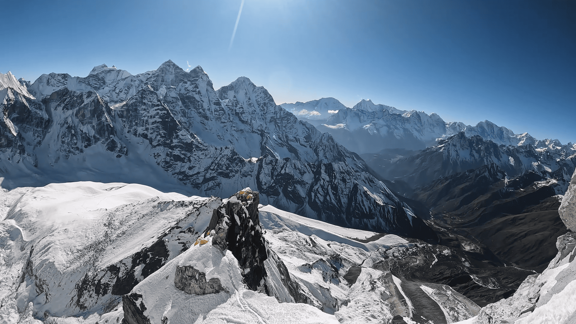
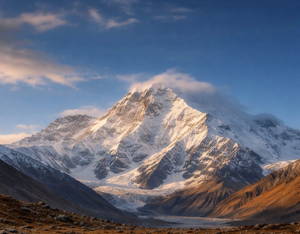
Every serious mountaineer who has ever walked the trail from Lukla to Everest Base Camp has stopped, looked up, and felt the pull. Ama Dablam Expedition does not blend into the Khumbu skyline; it dominates it. It's a perfect pyramid of rock and ice, the hanging glacier that gives the mountain its name, the impossibly sharp southwest ridge catching alpenglow at dusk. It is regularly voted one of the most beautiful mountains on Earth, and for the climbers standing beneath it, beauty is only part of the equation.

The other part is what it takes to reach the summit at 6,812 meters.

This is not a trekking peak with crampons. Ama Dablam is graded TD (Très Difficile) in the French alpine system, the same grade used for serious technical objectives in the Alps. The Yellow Tower. The Mushroom Ridge. Camp 2 is perched on narrow ledges with 1,500-meter drops on both sides. A summit push from the dark of a high-altitude midnight. These are not metaphors. They are the features of the standard Southwest Ridge route, and understanding each one honestly is the starting point for every serious 2026 or 2027 Ama Dablam expedition plan.

This guide covers everything: the mountain's history, the route in precise detail, the experience requirements that guides actually enforce, the cost breakdown, best seasons, permits, gear, training, and how to choose an operator. If you are genuinely planning Ama Dablam, read this before you spend a dollar.

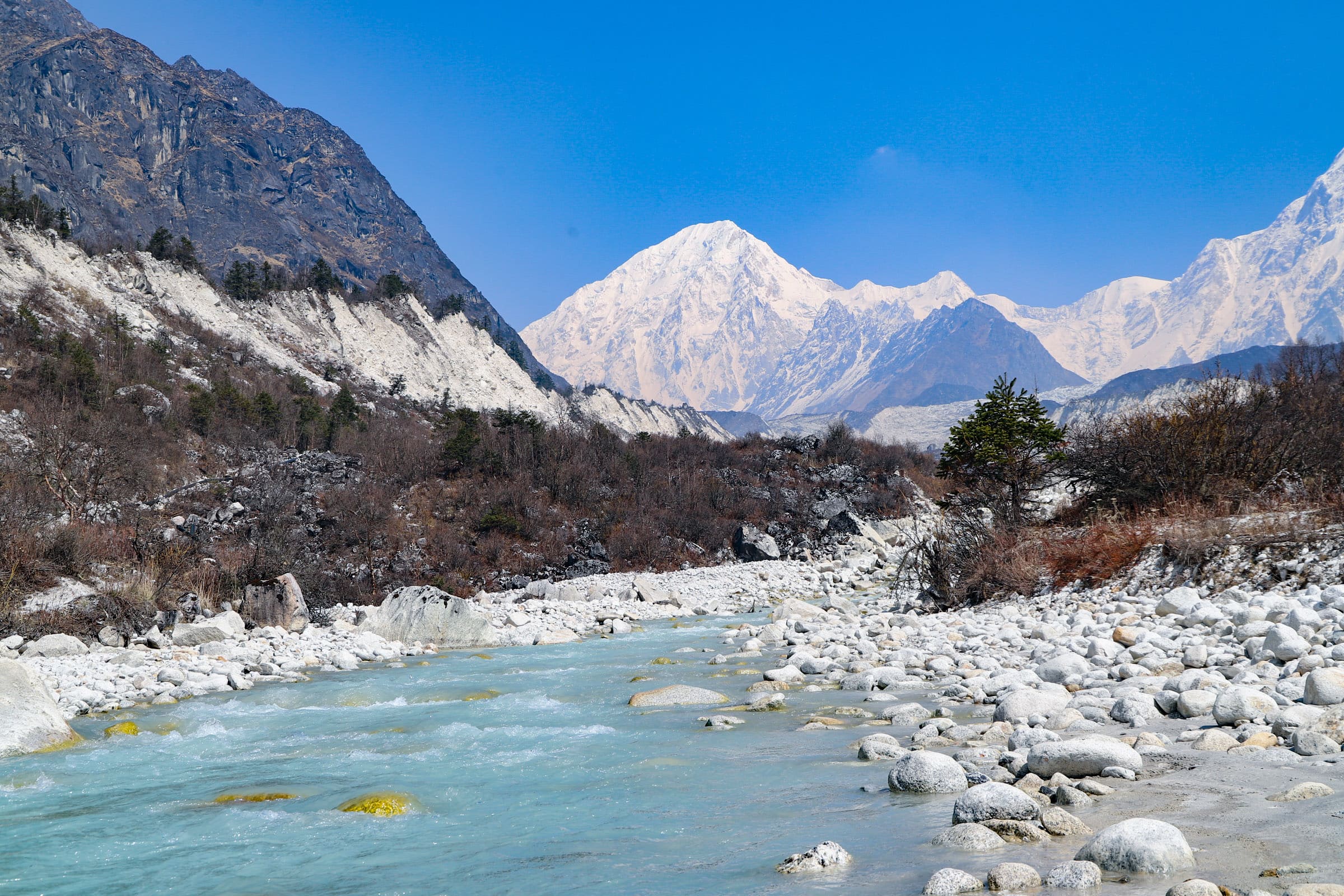
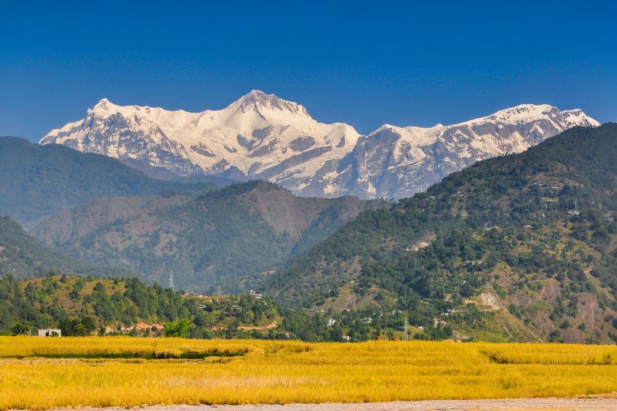
Ama Dablam stands at 6,812 meters (22,349 feet) in the Khumbu region of northeastern Nepal, rising from the Imja Valley approximately 6 km northeast of Pangboche and roughly 7 km southeast of Mount Everest. It is the third-most-climbed major peak in Nepal, after Everest and Island Peak, but unlike Island Peak, it is not a beginner's mountain.

The name translates from Sherpa as "Mother's Necklace," ama meaning mother, dablam referring to the traditional double-pendant amulet worn by Sherpa women. The hanging glacier on the southwest face is the Dablam, the pendant visually suspended between the mountain's two ridges like jewelry. It is a strikingly accurate description of one of the most recognizable peaks on Earth.

The main summit stands at 6,812 m. A lower western peak rises to 6,170 m. All commercial expeditions target the main summit via the Southwest Ridge, the original 1961 route, and the only route with established fixed rope infrastructure.

The first recorded attempt on Ama Dablam was by a British team in 1953, the same year Hillary and Norgay first summited Everest. Edmund Hillary, after seeing the mountain's near-vertical walls, reportedly called it unclimbable. Eight years later, on 13 March 1961, his own Silver Hut Scientific Expedition changed that assessment. Mike Gill (New Zealand), Barry Bishop (USA), Mike Ward (UK), and Wally Romanes (New Zealand) completed the first ascent via the Southwest Ridge, the route that remains the standard today.

Since 1961, hundreds of expeditions have attempted Ama Dablam. The summit success rate for well-prepared climbers with reputable operators consistently runs 60–75%, reflecting the mountain's genuine technical difficulty. This is not a peak where fitness alone determines outcome.

The conventional wisdom in Himalayan climbing is a progression: trekking peaks, then 7,000-meter peaks, then 8,000-meter peaks. Ama Dablam disrupts that linear thinking entirely.

At 6,812 m, it is lower than Manaslu (8,163 m) by more than a kilometer. But technically, it is harder than Cho Oyu and comparable to sections of the Lhotse Face on Everest. For climbers whose primary interest is technical alpine climbing, rock, mixed, and ice rather than pure altitude, Ama Dablam sits in a unique position: the hardest technically rewarding climb available without the commitment of a two-month 8,000-meter expedition.

Cost: A full-service Ama Dablam expedition runs USD 5,000–9,000 with a reputable Nepali operator and USD 8,000–15,000 with an international operator, a fraction of Everest's USD 45,000–100,000.

Duration: A standard expedition runs 28–35 days, far shorter than the 55–65 days required for Everest or Manaslu.

Prestige: In the mountaineering community, an Ama Dablam summit is a widely recognized milestone. The technical demands of the route — the Yellow Tower, the Mushroom Ridge, and the exposed Camp 2 mean that summiting carries genuine credentials.

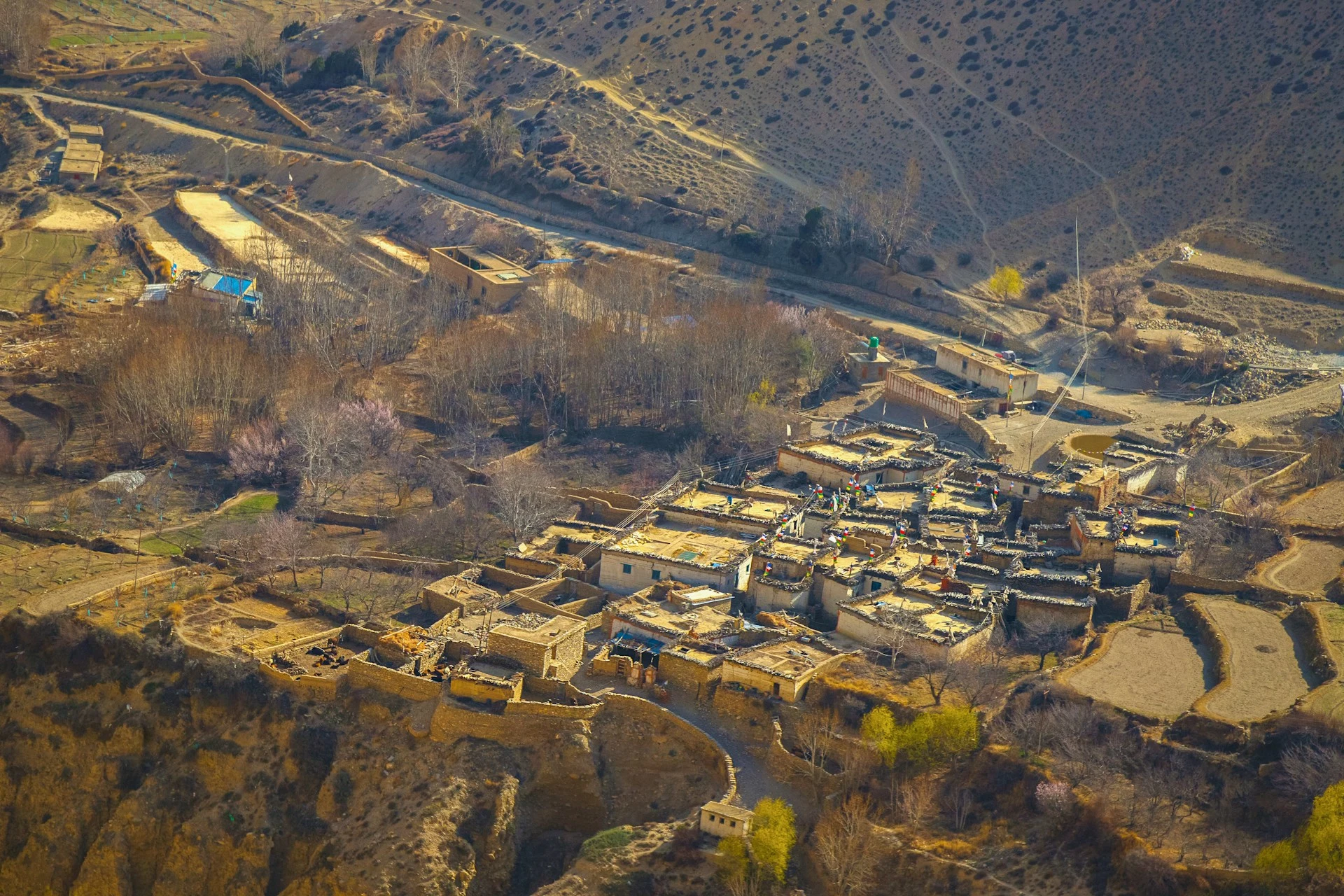
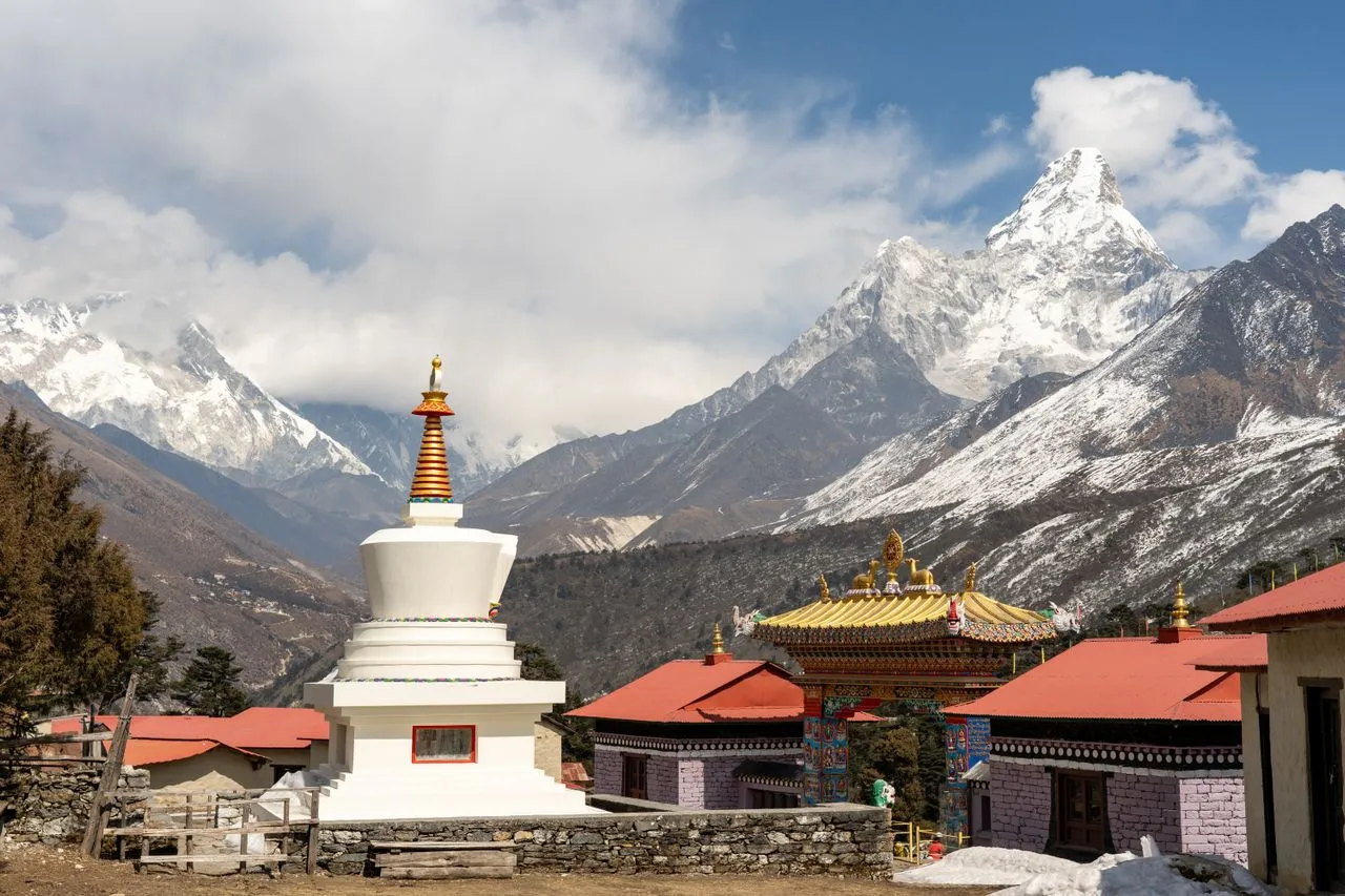
Position: Ama Dablam sits at the intersection of the Everest Base Camp trail and serious mountaineering. The approach trek passes through Namche Bazaar, Tengboche, and Pangboche, among the most beautiful valleys in Nepal. For climbers who want the full Khumbu experience alongside a serious summit, no other peak delivers it as efficiently.

This is the question most competitors in the content space answer dishonestly. Let's be direct.

Ama Dablam is not for beginners. It is not suitable for trekkers who have never used a jumar. It is not a "step up" from Mera Peak for someone with no technical climbing background. The mountain's own features will reveal this to anyone who arrives underqualified, typically at the Yellow Tower, where a 90-degree vertical granite step at 5,900 m in mountaineering boots with a loaded pack separates experienced technical climbers from everyone else.

Reputable operators require the following before accepting clients:

Rock climbing experience: Ability to climb at 5.7–5.10 (YDS) grade at sea level, with experience translating that to mountaineering boots and crampons on mixed terrain. The Yellow Tower is graded 5.5–5.8, depending on conditions. This sounds moderate, but it is in double boots, at 5,900 m, on a narrow ridge with 1,500-meter exposure below.

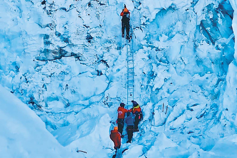
Fixed rope proficiency: Complete comfort ascending fixed lines with a jumar (ascender) while managing a loaded pack. Also comfortable abseiling (rappelling) on descent under the same conditions. Critically active climbing while on fixed lines, not passive hauling. Guides reject the "passive hauling" approach; you must be using hands and feet to climb while the rope provides protection.

Ice axe and crampon technique: Confident movement on 40–60 degree ice and snow slopes. Self-arrest. Front-pointing with crampons. The summit approach above Camp 2 involves sustained 55-degree snow and ice.

Multi-pitch experience: Some experience on multi-pitch alpine or rock routes, with comfort moving between technical sections over a full day of climbing.

The following prior objectives are considered adequate preparation by most serious Ama Dablam operators: Lobuche East + Island Peak combined; Aconcagua (6,961 m) with technical ascent variant; any 5,000–6,500 m technical trekking peak combined with genuine multi-pitch rock climbing experience. Prior 7,000-meter or 8,000-meter summits place you well above the minimum.

Island Peak alone is generally not sufficient as the only prior mountaineering experience. Mera Peak alone is not sufficient. Both involve glacier walking with crampons and basic fixed rope use, but neither features the vertical technical terrain that Ama Dablam's Yellow Tower and Grey Tower demand.

Before booking any Ama Dablam expedition, ask yourself: Can I lead a pitch of 5.7 rock in running shoes? Can I follow the same pitch in mountaineering double boots at altitude, wearing crampons, carrying a 10 kg pack, in minus-20°C conditions? If the answer to the second question is uncertain, that uncertainty is where the summit attempt fails — typically at 5,900 m with an entire descent still required.

Arrive honestly about your level. Good operators will assess you at Base Camp and adjust expectations or turn you back rather than put you in danger above the Yellow Tower.

The Southwest Ridge, first climbed in 1961, accounts for more than 95% of all Ama Dablam summit attempts. It is the established commercial route, with fixed ropes installed by Sherpa route-setters before each season. The route runs from Base Camp at 4,600 m to the summit at 6,812 m, a vertical gain of 2,212 m across a series of increasingly technical sections.

One important route evolution in 2026: most experienced operators now push directly from Camp 2 to the summit, bypassing an overnight stay at Camp 3. The reason is objective safety. Traditional Camp 3 (6,200–6,300 m) sits directly beneath the Dablam hanging glacier. In 2006, a serac collapse triggered an avalanche that killed six climbers at Camp 3, the deadliest single incident in Ama Dablam's history. Since approximately 2021, over 90% of commercial teams no longer sleep at Camp 3, instead making an alpine-style summit push from Camp 2, typically departing around midnight.

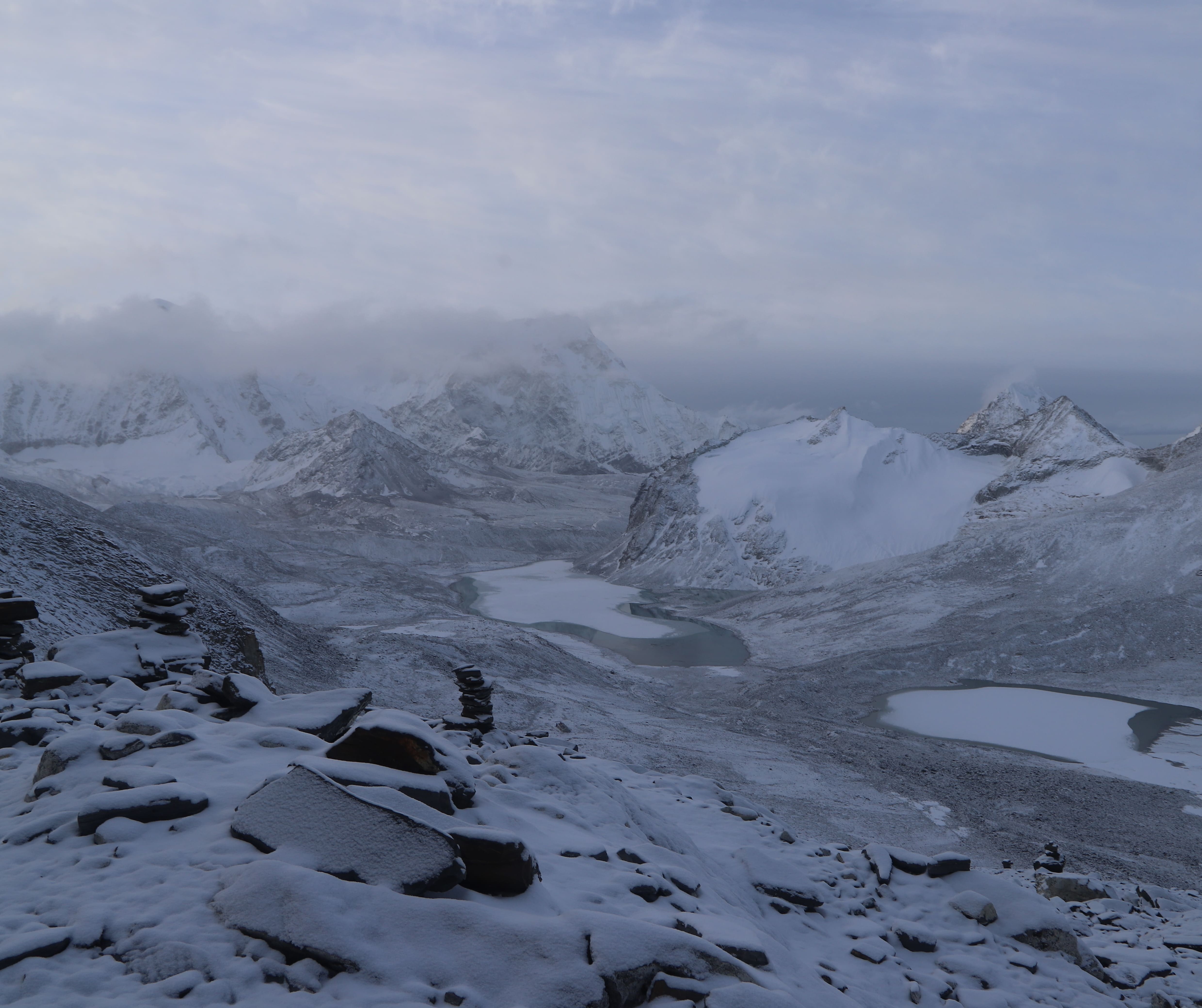
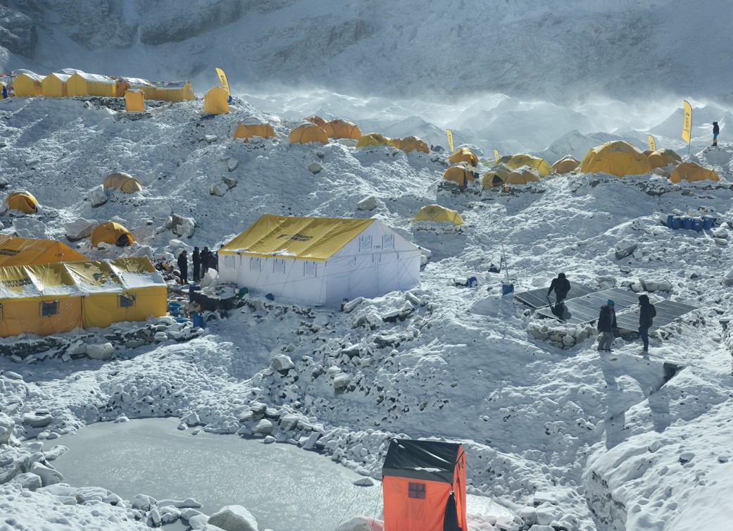
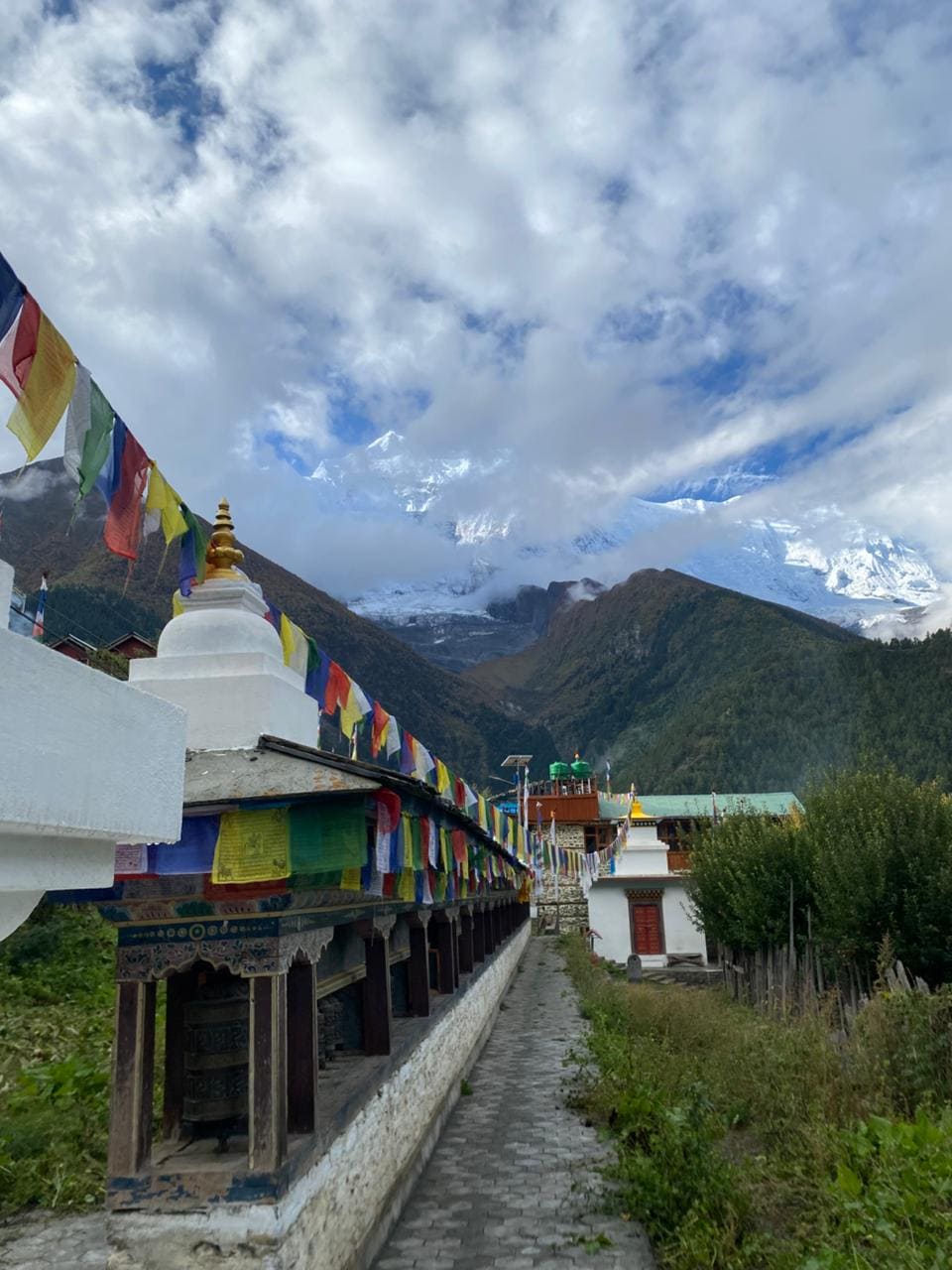
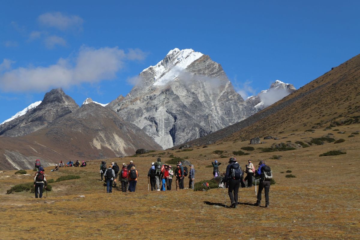
Ama Dablam Base Camp is one of the most pleasant in Nepal, a grassy alpine meadow with a clear stream, yaks grazing on surrounding slopes, and prayer flags marking the cook tents and sleeping areas of multiple expedition teams. It sits below the towering southwest face, with a direct view of the Yellow Tower and the ridge that leads to the summit.

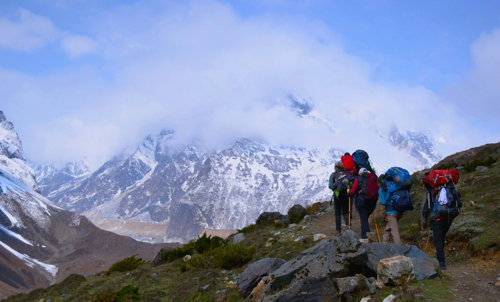
At Base Camp, your climbing guide conducts multi-day training before any movement onto the mountain: fixed rope ascending, jumar technique, crampon walking on nearby rock and ice walls, ice axe arrest, abseiling practice, and emergency communication protocols. This training is not optional and should not be rushed. Most serious operators allocate 5–7 days at Base Camp for training and acclimatization before the first rotation.

The Puja ceremony is held at Base Camp before climbing begins — a Sherpa Buddhist blessing conducted by a lama, seeking permission from the mountain deity and protection for all climbers and guides. Every expedition team participates, regardless of personal religious background. This is a cornerstone of Sherpa culture and expedition ethics in the Khumbu.

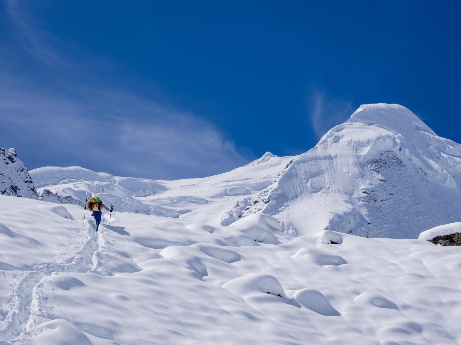
From Base Camp, the approach to Camp 1 begins with a moraine walk, then gains rocky terrain along the lower Southwest Ridge. The route is non-technical initially — boulder hopping and steep scree give way to the first fixed rope sections as the ridge narrows. Camp 1 itself is positioned on narrow granite ledges with space for approximately 5–6 tents — a genuine high-altitude camp requiring careful movement outside the tent.

The acclimatization strategy involves rotating to Camp 1 and back to Base Camp at least once before attempting higher camps. This up-down-up-down pattern — climb high, sleep low — is the most effective acclimatization strategy and is built into every serious Ama Dablam itinerary.

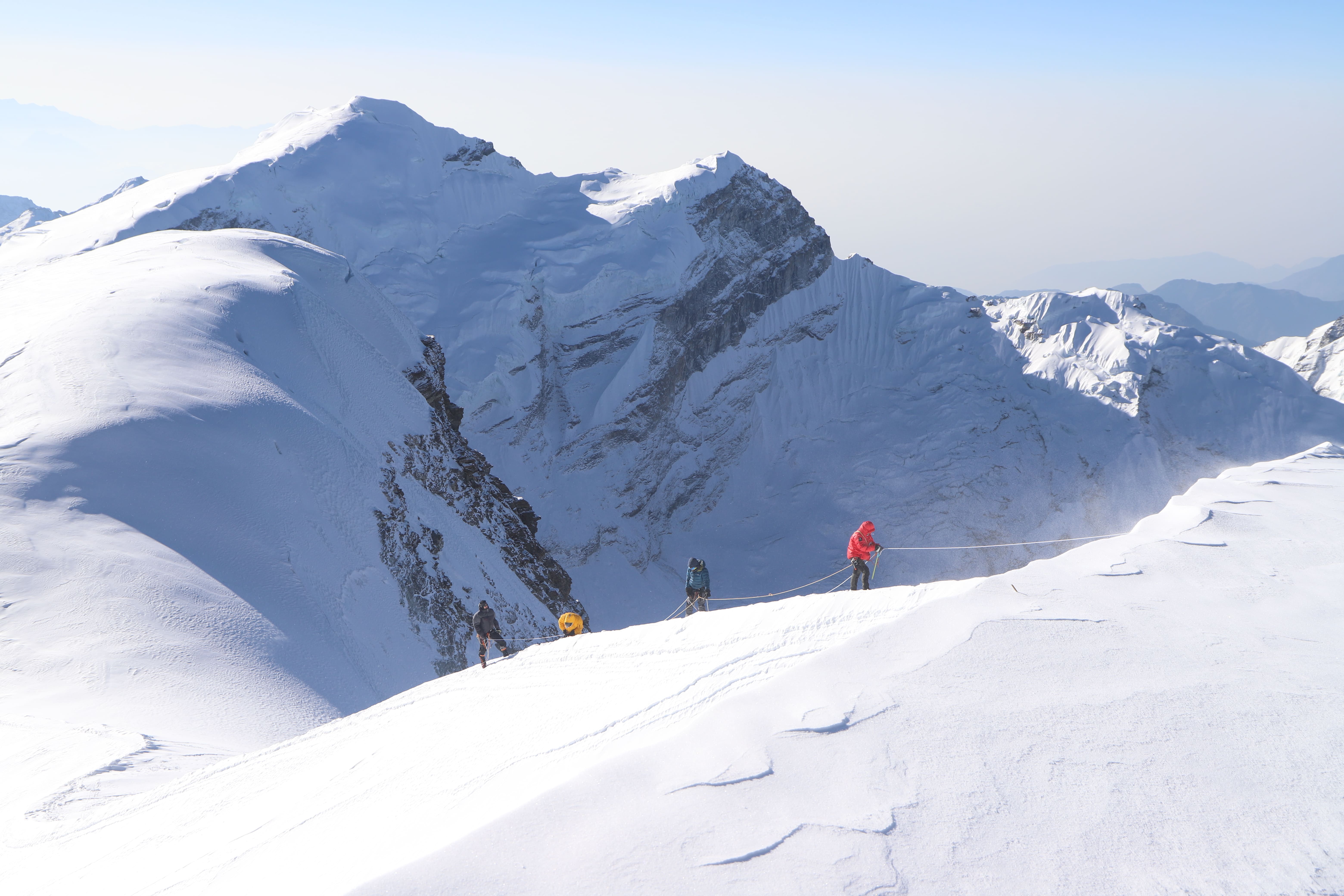
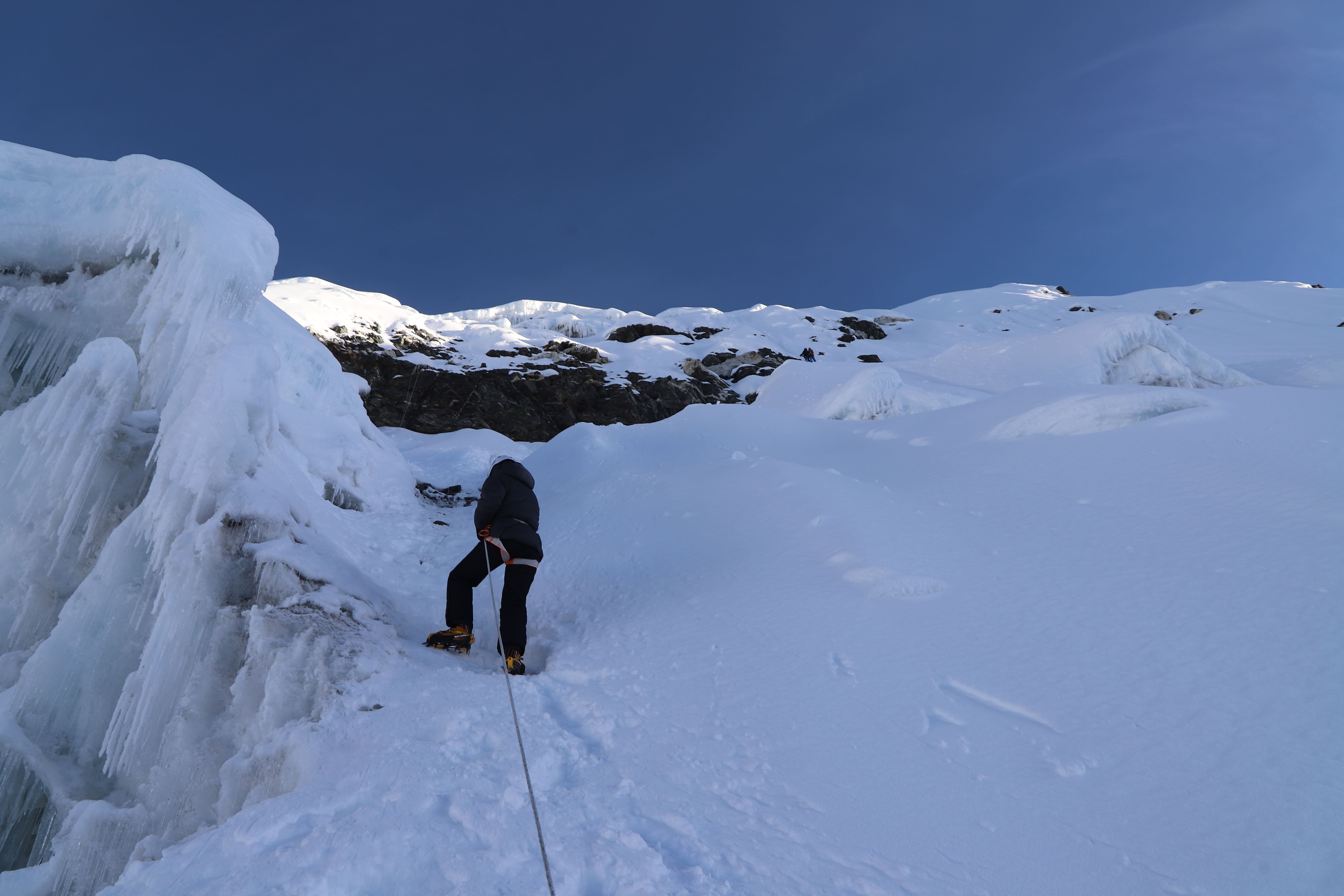
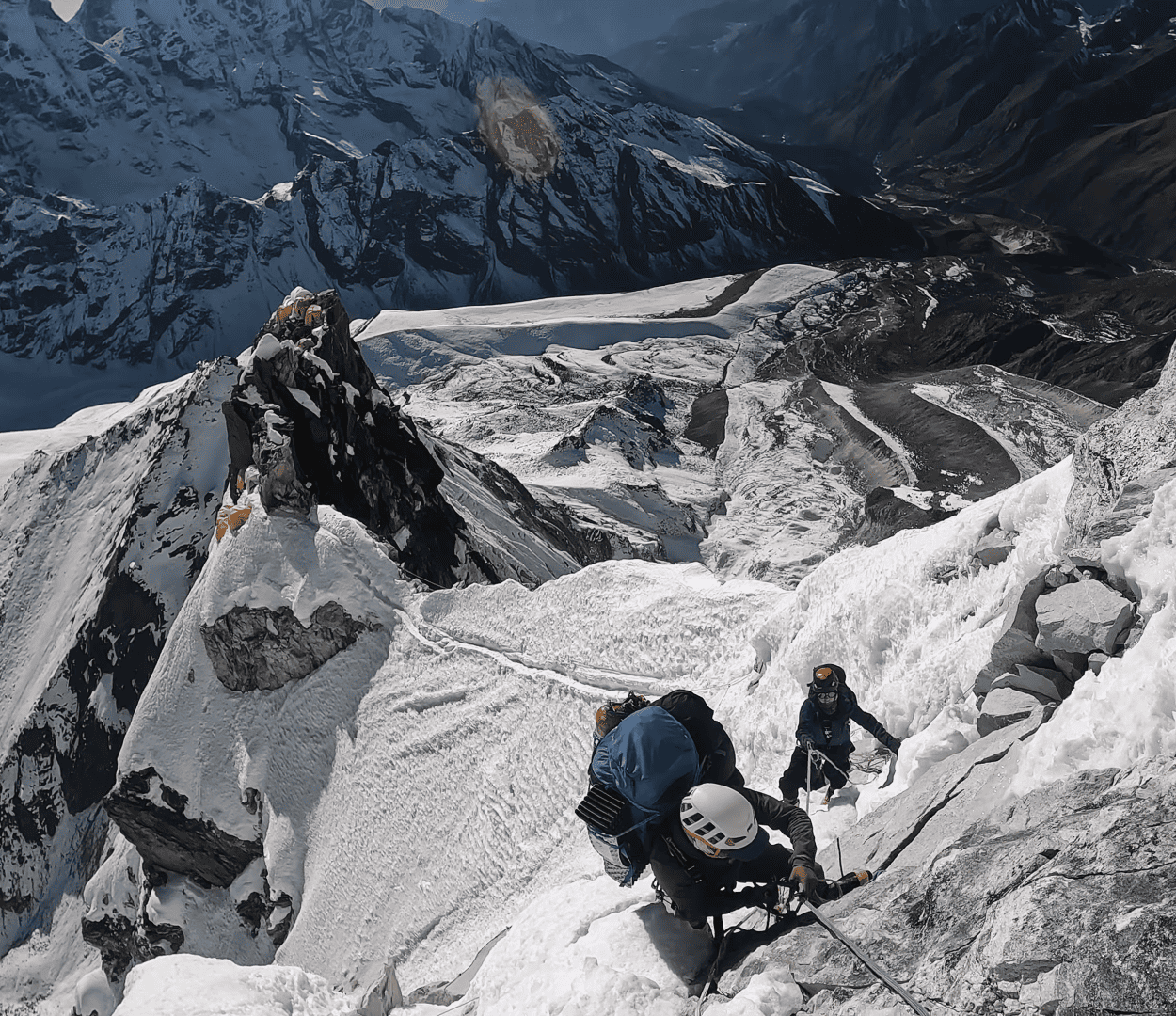
The route from Camp 1 to Camp 2 is the technical heart of the expedition and the primary filter for climbers who are and are not ready for Ama Dablam. The climbing begins on polished granite slabs at 40–50 degrees before encountering the defining feature of the route: the Yellow Tower.

The Yellow Tower is a 15–20 meter near-vertical granite step, its distinctive brownish-yellow coloring visible from Pangboche village far below. It is the most discussed and most feared section of the Southwest Ridge for good reason.

Fixed ropes are installed on 3–6 parallel lines through the Yellow Tower by Sherpa route-setters before the season. But fixed ropes on the Yellow Tower do not reduce the difficulty to a mechanical exercise. This section requires genuine active rock climbing using hands and feet to climb the granite features, while the jumar and rope provide protection. The grade is 5.5–5.8 YDS, depending on conditions (ice on the holds makes it significantly harder). Exposure below is immediate and dramatic; a slip without the rope protection would be fatal.

Above the Yellow Tower, the Grey Tower presents a second technical challenge, mixed Scottish winter Grade III/IV terrain, before the route traverses to Camp 2.

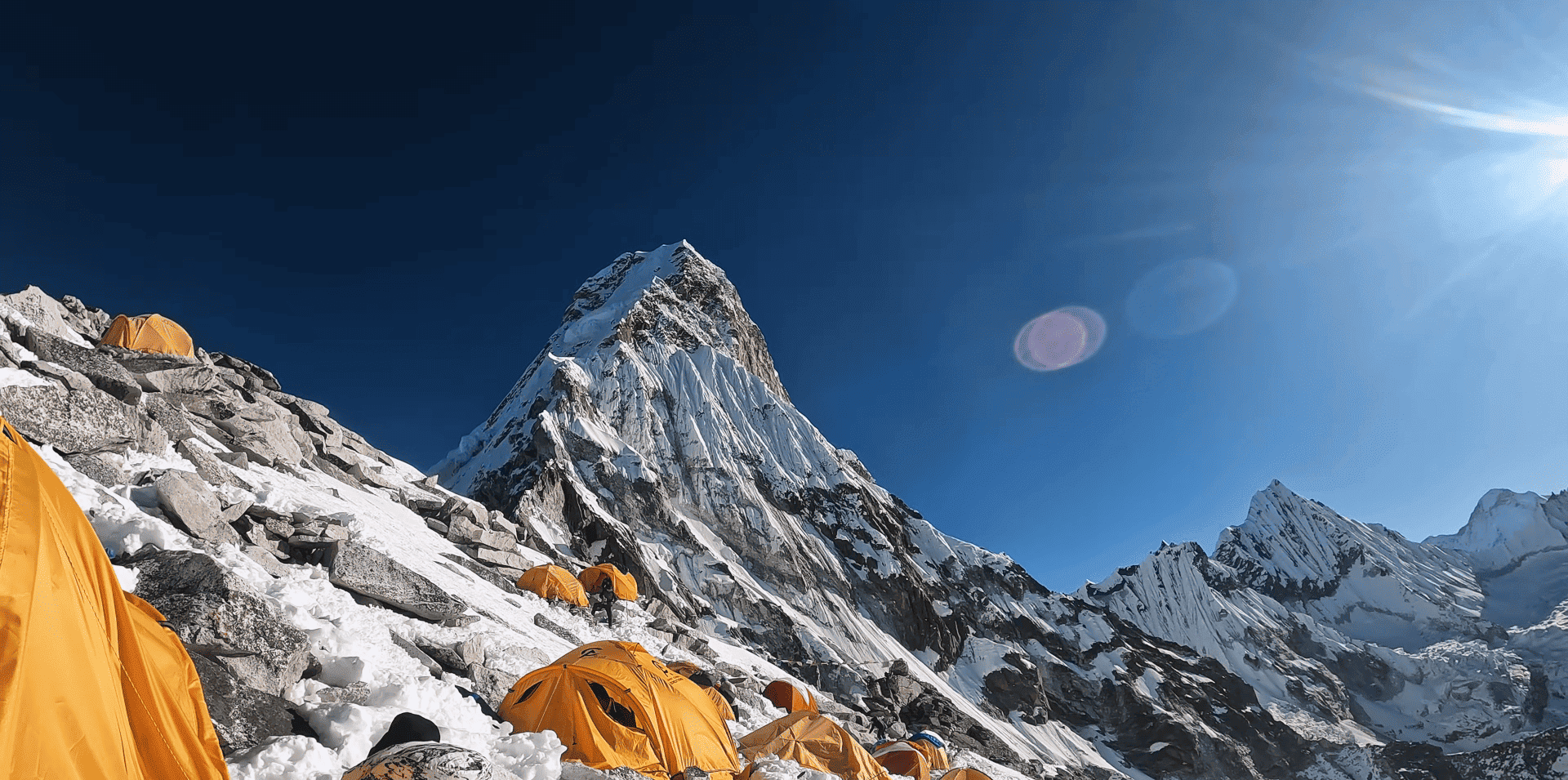
Camp 2 itself is built on small ledges on the mountain's southwest face. Space is limited to 6–8 tents. The exposure is extraordinary, on all sides, steep terrain drops away. This is where most teams spend the final night before a summit push, and where mental composure is as important as physical fitness.

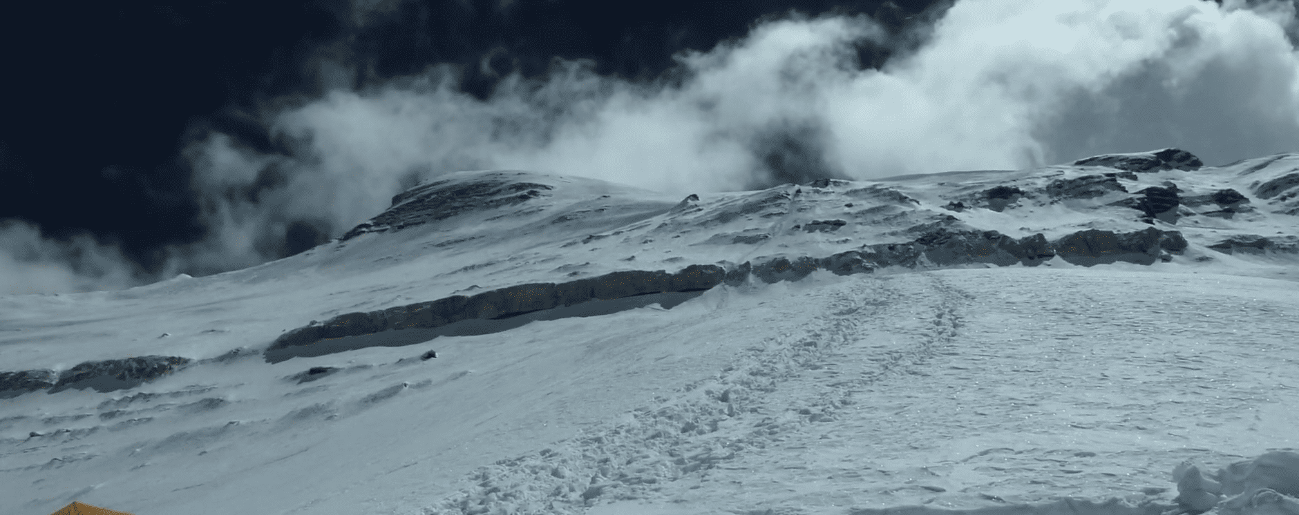
Above Camp 2, the route traverses the famous Mushroom Ridge, an exposed snow-ice arête with drops of 1,500–2,000 meters on both sides for several hundred meters of horizontal distance. The name comes from the bizarre mushroom-shaped ice formations that develop on the ridge due to prevailing wind patterns.

Moving along the Mushroom Ridge demands precise crampon placement, calm confidence in exposure, and complete trust in your technique. This is not a section where you can improve your skills in real time; it requires prior experience in a similar environment. For experienced alpine climbers, it is thrilling. For climbers who have only experienced glacier walking, this is the reason many summit attempts end here.

Traditional Camp 3 sits beneath the Dablam hanging glacier. As noted above, most modern operators use Camp 3 only as a waypoint during rotations to cache gear or take a brief rest, but do not sleep there overnight. The 2006 avalanche has permanently changed the risk calculation. Teams that maintain an overnight Camp 3 are accepting a documented, avoidable objective hazard.

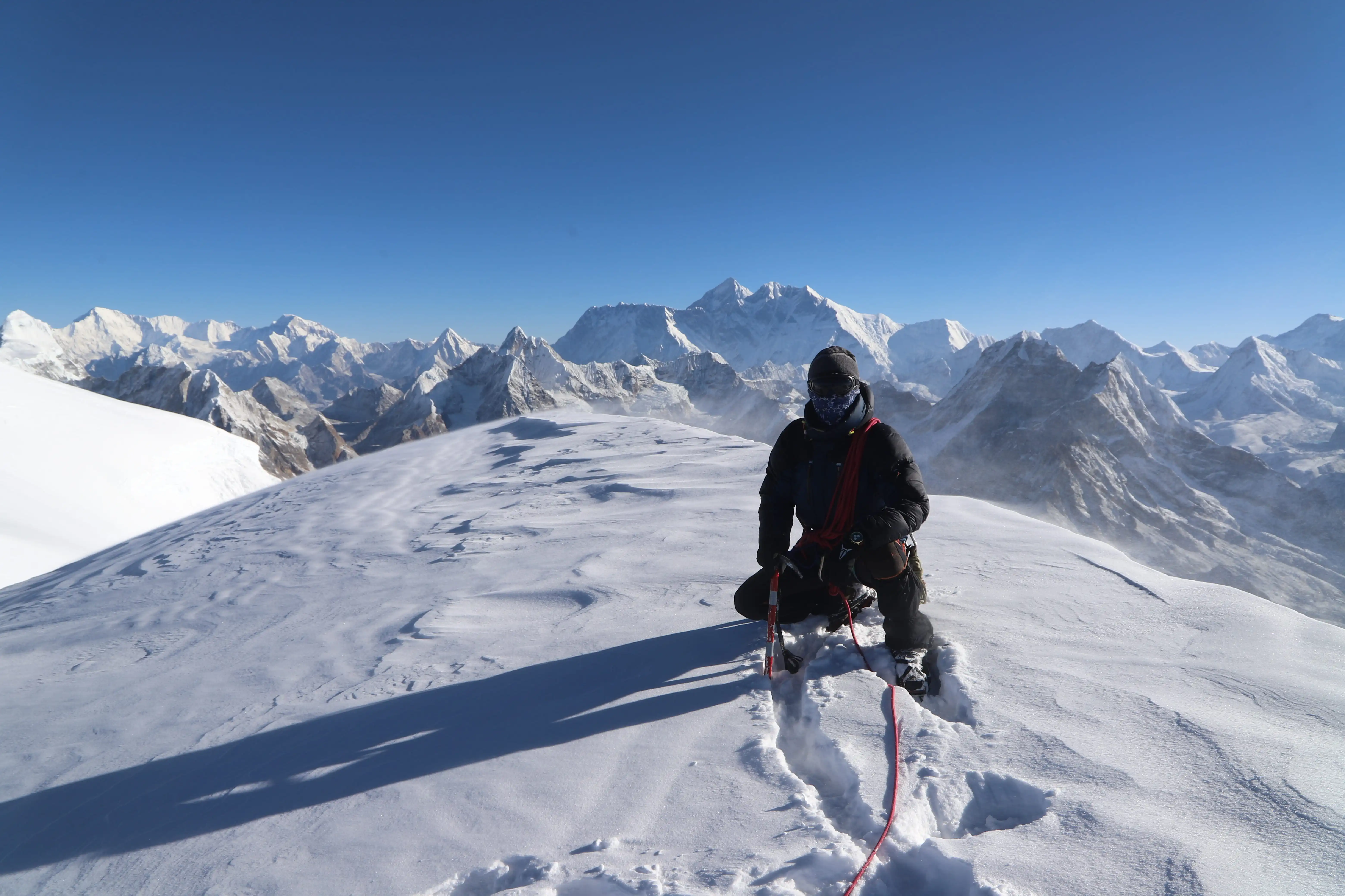
Most 2026 teams depart Camp 2 around midnight for the summit push. From Camp 2 to the summit covers approximately 800 vertical meters — a demanding summit day of 10–16 hours round trip. The terrain above Camp 2 transitions from the mixed rock/ice of the lower ridge to sustained steep snow and ice as the route approaches the Dablam glacier.

The Dablam Traverse, a final knife-edge arête below the summit, is the last technical obstacle before a 30–50 degree snowfield leads to the summit. The summit itself is narrow and exposed, but the view that awaits justifies every technical difficulty of the preceding days.

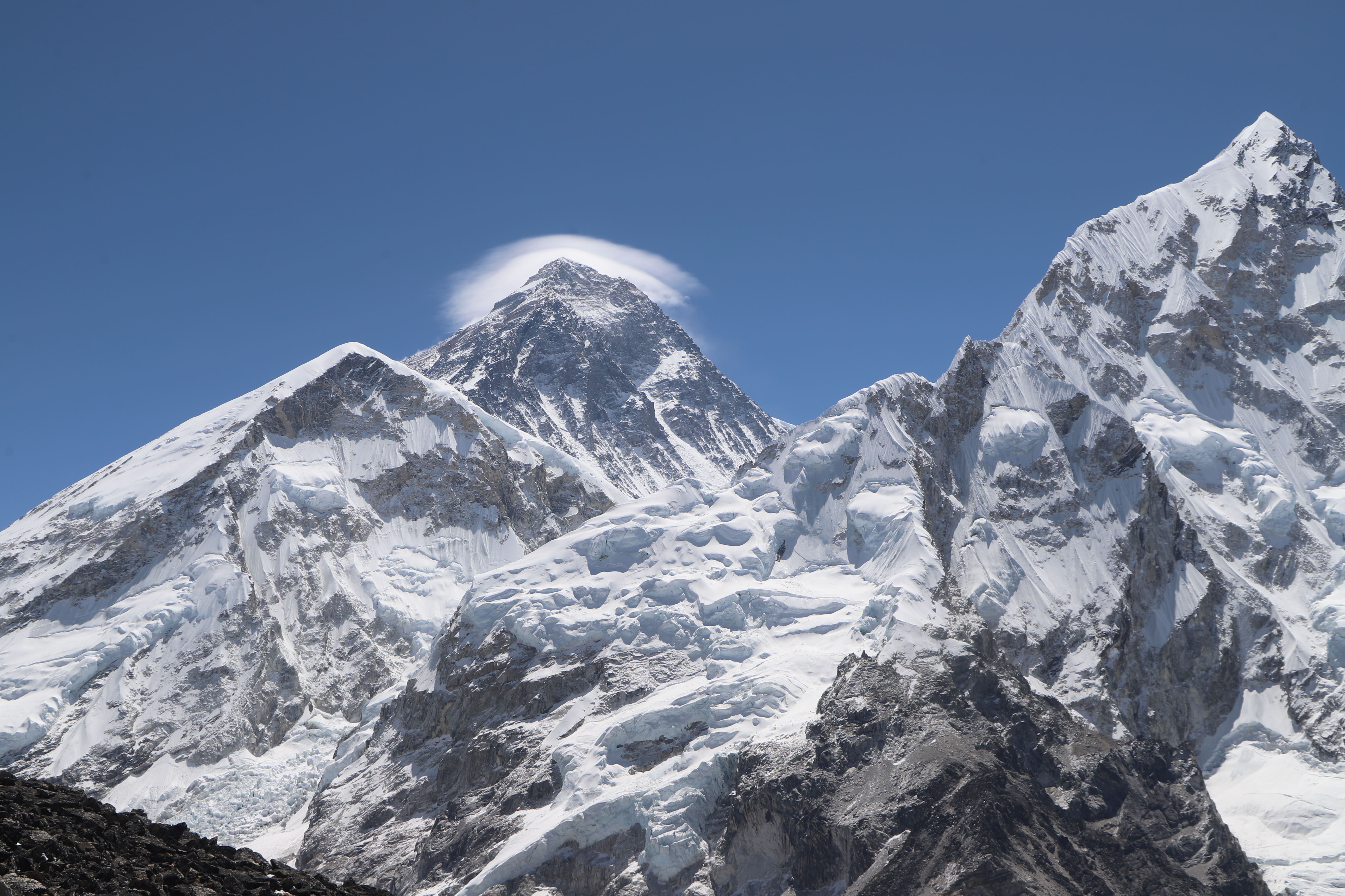
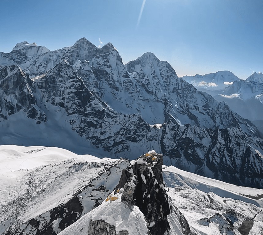
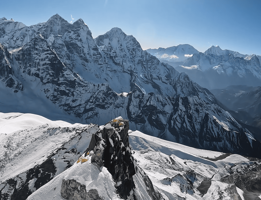
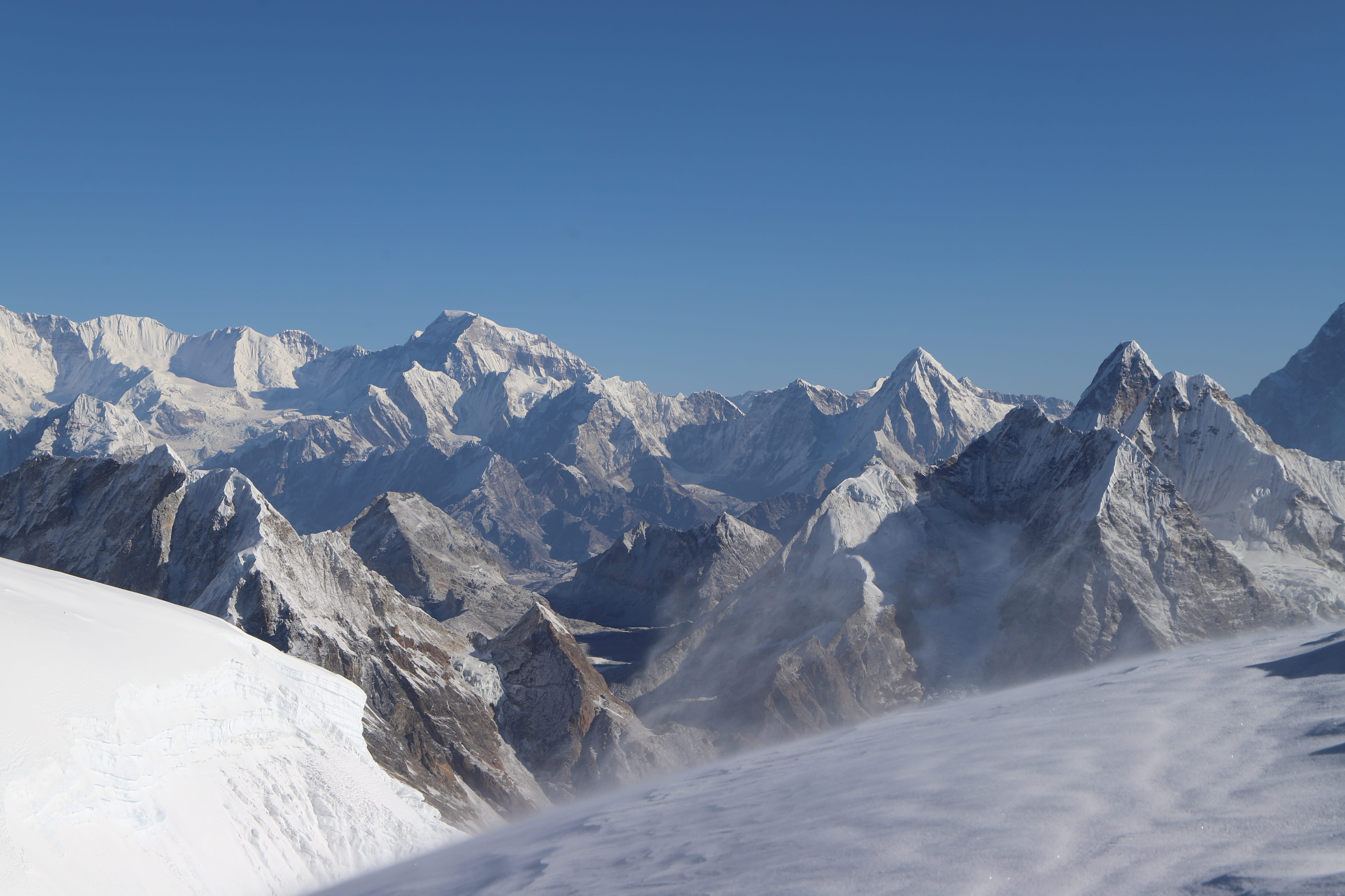
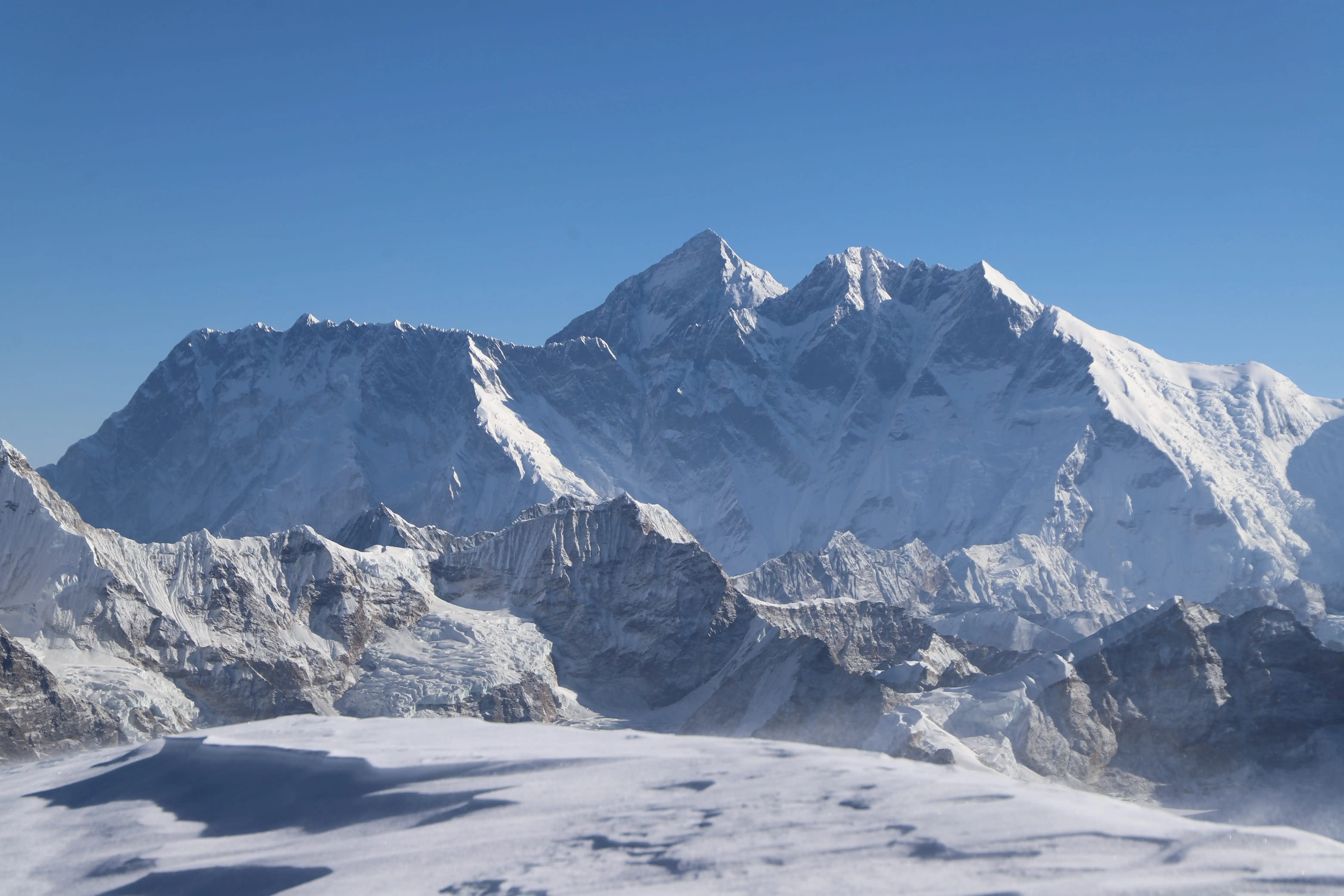
From 6,812 m on a clear morning, the panorama encompasses Everest (8,848 m), Lhotse (8,516 m), Makalu (8,485 m), Cho Oyu (8,188 m), Nuptse, Pumori, Kangchenjunga on the horizon, Shishapangma in Tibet, and the entire Khumbu region spread below in one of the most spectacular 360-degree mountain vistas achievable without an 8,000-meter permit.

The descent is as demanding as the ascent. Tired legs, depleted focus, and the technical sections of the Yellow Tower and Mushroom Ridge in descent require every bit of the technical discipline brought to the ascent. Most Ama Dablam accidents occur on descent. Move carefully, maintain rope discipline, and do not rush.

Ama Dablam sits in an unusual market position, more expensive than basic trekking peaks but dramatically cheaper than 8,000-meter objectives. Here is the honest, complete cost picture.

Operator Type Package Cost What It Reflects
Budget Nepali operator USD 4,500–6,000 Basic support, smaller Sherpa team, minimal base camp
Standard Nepali operator USD 6,000–9,000 Full support, 1:1 Sherpa ratio on summit, solid BC setup
International operator USD 9,000–15,000 Western expedition leader, premium BC, small team
Premium/luxury USD 15,000–20,000 Helicopter to/from BC, 5-star Kathmandu, private guide


A good standard package should include: Kathmandu hotel (3–4 nights), Lukla domestic flights, all trekking meals and accommodation, Base Camp full setup (personal tent, dining tent, kitchen, toilet), certified climbing Sherpa guide (1:1 for summit push), all fixed ropes and group climbing equipment, climbing permit, all government fees and taxes, liaison officer, and a Base Camp cook and support crew.

Permit Cost
NMA Climbing Permit (spring/autumn) USD 400 per person
NMA Climbing Permit (winter/monsoon) USD 200 per person
Sagarmatha National Park Entry ~USD 30 per person
Khumbu Pasang Lhamu Municipality ~USD 20–25 per person
Liaison Officer Government-mandated, included in package


The NMA permit for Ama Dablam at USD 400 is dramatically lower than the USD 3,000 charged for Nepal's 8,000-meter peaks or the USD 15,000 Everest permit, making it one of the most permit-efficient technical objectives in Nepal.

International flights, Nepal visa (USD 50 for 30 days), personal climbing gear (if not renting), travel and evacuation insurance (mandatory, budget USD 200–500 depending on coverage), personal snacks and beverages, Kathmandu extras (dining, shopping), WiFi and charging fees on the trail and at Base Camp, and Sherpa tips.

Tip your summit Sherpa after a successful ascent. The standard is USD 500–800 per Sherpa for Ama Dablam, with 10% of the total trip cost for supporting Base Camp staff. This is not optional in the climbing community — it reflects both gratitude and respect for professionals who accept personal risk on your behalf.

Budget Type All-In Total
Budget-conscious (Nepali operator) USD 7,000–10,000
Standard (recommended) USD 10,000–15,000
International/premium operator USD 15,000–25,000

Unlike Nepal's 8,000-meter peaks, where spring dominates because the jet stream is the controlling factor, Ama Dablam has two genuinely excellent climbing windows.

Autumn is the best and most popular season for Ama Dablam, and October–November is the gold standard. After the monsoon clears in late September, the Khumbu settles into the most stable weather of the year. Skies are typically clear, temperatures at altitude are cold but manageable, and the post-monsoon snowpack makes certain sections of the Southwest Ridge more climbable.

October in particular sees the peak concentration of Ama Dablam expeditions, with multiple teams on the route simultaneously, which means fixed ropes are well-maintained, and Base Camp has the energy of a genuine expedition community.

November is slightly less busy and progressively colder, but many guides consider late October to mid-November the finest conditions of any season on the mountain.

Book for autumn 2026: Permit applications and operator bookings for the October–November 2026 season should be submitted by June–July 2026.

Spring is Ama Dablam's secondary season, with excellent conditions but significantly fewer teams, because most operators and Sherpas are focused on Everest and other 8,000-meter spring objectives. For climbers who prefer a quieter mountain with fewer team interactions and less crowding at Camp 2's limited tent spaces, spring is a genuinely appealing choice.

The weather window in spring is similar to autumn, stable conditions with manageable wind and temperature. However, spring can bring more snowfall on the route, making the granite sections more challenging. Route-fixing also begins later in spring as Icefall Doctor teams prioritize the Everest corridor.

Best spring months: Late April through May.

Winter Ama Dablam is a minority-sport objective, cold, with shorter days and reduced summit windows. A small number of experienced mountaineers specifically target November–December for the uncrowded conditions and the extra technical challenge of winter mixed conditions on the Yellow Tower. It is not recommended for first-time Ama Dablam climbers.

Day Stage Altitude Notes
1 Arrive Kathmandu 1,400 m Hotel, team briefing, permit collection
2 Kathmandu — gear check 1,400 m Thamel shopping, permit finalization
3 Fly Kathmandu → Lukla, trek to Phakding 2,610 m 35-min flight, 3-hr trek
4 Trek Phakding → Namche Bazaar 3,440 m 5–6 hrs, Sagarmatha National Park entry
5 Acclimatization day, Namche Bazaar 3,440 m Hike to Everest View Hotel (3,880 m)
6 Trek Namche → Tengboche 3,870 m 5 hrs, Tengboche Monastery blessing
7 Trek Tengboche → Pangboche 3,985 m 3 hrs
8 Trek Pangboche → Ama Dablam Base Camp 4,600 m 3 hrs, Puja ceremony
9–10 Base Camp — acclimatization training 4,600 m Fixed rope, jumar, crampon, ice axe training
11 Rotation 1: BC → Camp 1 → BC 5,700 m First touch of technical terrain
12 Rest and recovery at BC 4,600 m Equipment check, weather monitoring
13–14 Rotation 2: BC → Camp 1 → Camp 2 → BC 6,020 m Yellow Tower first attempt, Camp 2 touch
15–16 Rest at BC 4,600 m Recovery critical before the summit push
17 Summit push begins: BC → Camp 1 5,700 m Rest at Camp 1
18 Camp 1 → Camp 2 6,020 m Yellow Tower, Grey Tower, Mushroom Ridge
19 Summit Day: Camp 2 → Summit → BC 6,812 m 10–16 hr round trip, midnight start
20 Contingency/rest at BC 4,600 m Weather window backup
21 Contingency/rest at BC 4,600 m Second attempt window if needed
22 Trek BC → Pangboche 3,985 m Begin descent
23 Trek Pangboche → Namche Bazaar 3,440 m  
24 Trek Namche → Lukla 2,860 m  
25 Fly Lukla → Kathmandu 1,400 m A weather buffer day is always advised
26 Buffer day Kathmandu (Lukla delay contingency) 1,400 m  
27–28 Recovery, celebration, shopping, departure 1,400 m  


Most operators build 2 contingency days into the summit window at Base Camp. Weather forecasting services provide 48–72 hour summit-zone forecasts. The guide makes the final go/no-go call based on wind, temperature, and visibility, not fixed dates.

Training for Ama Dablam is fundamentally different from training for EBC or Mera Peak because it has two components: endurance and technical skill. Both must be developed simultaneously and cannot be substituted for each other.

The baseline fitness requirement: ability to hike 6–8 hours with a 15–20 kg pack over steep terrain and recover functionally overnight. Beyond this baseline, the specific demands of Ama Dablam are:

Lower body strength: Squats, Bulgarian split squats, step-ups with a loaded pack (15 kg minimum), and leg press. The descent from Camp 2 to Base Camp after a summit push taxes the quadriceps severely.

Upper body and grip strength: Pull-ups, dead hangs, farmer's carries (both hands), and rope climbing. The Yellow Tower requires genuine upper-body pulling strength while wearing heavy gloves and double boots.

Cardiovascular base: Long hiking days (6+ hours) with elevation gain. Stair climbing with a pack twice weekly. Running or cycling 3–4 days per week. The summit day cardiovascular demand is sustained output for 10–16 hours at altitude.

Core stability: Planks, loaded carries, and balance work for movement on exposed terrain where core stability is the margin between composure and fear.

No amount of gym training substitutes for the following skills practiced on real terrain:

Multi-pitch rock climbing: At minimum 5.7–5.8 YDS routes, ideally with some experience in mountaineering boots. Climbing at a local crag or sport venue in trail shoes does not directly translate schedule sessions specifically in boots on rough rock.

Ice climbing: WI2–WI3 ice routes (or equivalent). Front-pointing on 50–60 degree ice, ice axe placements, and crampon confidence. If you have no ice climbing background, a dedicated ice climbing course (3–5 days minimum) is a non-negotiable prerequisite.

Jumar and abseiling systems: Practice ascending fixed lines efficiently — not hauling, but climbing while clipped. Practice abseiling with a loaded pack. These should be automatic movements by the time you arrive at Base Camp.

Alpine training course: An alpine climbing course in the Alps, Rockies, Cascades, or comparable range gives you exposure to multi-day technical objectives, high-altitude camping, and complex descent situations in a controlled environment before the Himalaya. Many operators offer or recommend pre-expedition workshops.

Ama Dablam gear sits between trekking peak equipment and full 8,000-meter expedition kit. The mountain does not require supplemental oxygen for most climbers under current conditions, but every other item of high-altitude technical clothing and hardware matters.

Crampons (12-point technical, Grivel or Petzl), ice axe (70 cm technical axe), jumar/ascender (Petzl or Kong), harness (suitable for mountaineering, comfortable over bulk clothing), locking carabiners (minimum 4), belay/abseil device, helmet, trekking poles for approach.

Double mountaineering boots are the standard for Ama Dablam. Single boots may be adequate in warm autumn conditions for very experienced climbers, but double boots are strongly recommended. La Sportiva G2 Evo, Scarpa Phantom 8000, or Millet Everest are appropriate. Test fit is critical, as pressure points become frostbite above Camp 1.

Merino wool base layer (thermal and moisture-wicking), mid-layer fleece, insulated jacket (600+ fill down), down expedition pants for high camp, waterproof and windproof hardshell jacket and trousers, 5-finger gloves plus liner and over-mitts. Balaclava and expedition-weight hat. Goggles (UV-rated, fog-resistant, not sunglasses).

Sleeping bag rated to –20°C for high camp comfort. The Khumbu gets cold at night even in autumn. Do not economize on sleeping system quality for an expedition requiring multiple nights at 5,700 m and 6,020 m.

Ama Dablam does not routinely require supplemental oxygen for fit, well-acclimatized climbers. However, responsible operators carry emergency oxygen in case of severe AMS, HAPE, or HACE symptoms. Ask your operator what their protocol is and whether emergency Oâ‚‚ is included in the package.

At 6,812 m, Ama Dablam sits well above the altitude threshold where AMS, HAPE (High Altitude Pulmonary Edema), and HACE (High Altitude Cerebral Edema) become serious risks. The acclimatization rotations built into every professional Ama Dablam itinerary are not logistical filler; they are the physiological preparation that makes the summit push survivable.

The golden rule applies here as everywhere above 3,000 m: never ascend more than 400–500 meters of sleeping elevation per day. The BC to Camp 1 to BC to Camp 2 to BC rotation pattern is specifically designed around this rule.

Warning signs requiring immediate descent: Severe unresponsive headache, loss of coordination (ataxia), confusion or disorientation, shortness of breath at rest, persistent cough, pink frothy sputum (HAPE indicator). These symptoms at altitude are emergencies. Descent is the treatment, not rest, not waiting, not hoping. Descent.

Your operator must have a protocol for emergency evacuation. Helicopter rescue from the Ama Dablam Base Camp area is feasible — Kathmandu-based helicopters can reach the Khumbu in approximately 45 minutes in flyable conditions. Verify your travel insurance explicitly covers helicopter evacuation from this altitude and region before departing.

All Ama Dablam permits must be arranged through a registered Nepali trekking and expedition agency. You cannot obtain them independently as a foreign national.

NMA Climbing Permit: Issued by the Nepal Mountaineering Association. Cost USD 400 per person for the spring and autumn seasons. Your agency submits the application to the NMA with your passport copy, photo, and expedition details. Processing takes 7–14 days — apply at minimum 30 days before your intended expedition start.

Sagarmatha National Park Entry Permit: Required for the approach trek through the Khumbu. Checked at the entry gate at Monjo.

Khumbu Pasang Lhamu Rural Municipality Permit: A local area permit required for trekking in the Khumbu region, obtained in Lukla or pre-arranged by your agency.

Liaison Officer: The Government of Nepal mandates a liaison officer for all mountaineering expeditions. Their salary, accommodation, and expenses are the responsibility of the expedition team, typically included in the package cost.

The NMA also requires a refundable garbage deposit, ensuring all waste is carried off the mountain. Your agency handles this as part of the permit process.

The operator's decision on Ama Dablam carries more direct safety consequences than on any trekking peak, for a simple reason: on a technical mountain with 1,500-meter exposure, the quality of your guide's assessment and intervention ability directly determines whether a borderline moment becomes a safe retreat or an accident.

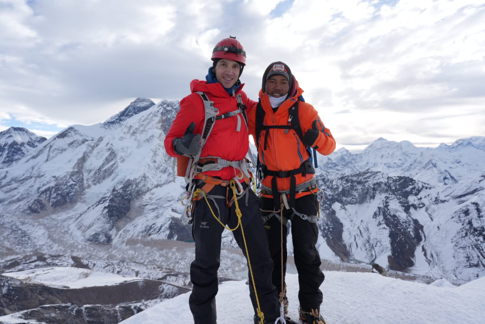
1:1 Sherpa-to-client ratio on summit day. On the Yellow Tower, the Mushroom Ridge, and the Dablam Traverse, your personal climbing Sherpa needs to be watching your movement and able to intervene without being responsible for another client simultaneously. Any operator offering less than 1:1 on summit day is compromising your safety margin.

NMA-certified climbing guides. The Nepal Mountaineering Association certifies climbing guides at specific technical standards. Ask for your guide's NMA certification number and verify it.

Base Camp medical protocol. What does the operator do if a client develops severe AMS at Camp 2? Who makes the evacuation decision? How is a helicopter rescue initiated? These questions should have specific, practiced answers.

Fixed ropes and equipment standards. Ask what rope specification is used for fixed lines, who installs them, and how often they are inspected during the expedition. This is not paranoid — deteriorating fixed ropes on the Yellow Tower present real danger.

Realistic summit day planning. An operator who tells every client they will summit is not operating honestly. A good operator will assess your performance during rotations and give you an honest evaluation of your summit prospects before the push. They will also set and enforce a turn-around time.

Any package below USD 4,000 for a full Ama Dablam expedition is cutting something: Sherpa quality, insurance, rope standards, or guide certification. The correlation between low price and poor safety outcomes is consistent across Himalayan mountaineering data. On a technical mountain, this correlation has life-altering consequences.

This is the most common comparative question from climbers planning their first serious Nepal objective.

Choose Ama Dablam if: You have prior technical climbing experience (5.7+ rock, ice climbing, multi-pitch), you want the most beautiful mountain in the Khumbu, you want a genuine technical challenge with serious mountaineering prestige, and you are not deterred by 1,500-meter exposure on an exposed ridge.

Choose Island Peak if: This is your first crampon-and-rope experience, you have strong trekking fitness but limited technical background, you want to combine a summit with EBC in a cost-effective package, or you are using this as a technical foundation for Ama Dablam in a subsequent season.

Choose Lobuche East if: You want a summit directly on the EBC route, you prefer less technical terrain than Ama Dablam, or you are building confidence with glacier travel and basic fixed rope technique before stepping up.

The correct sequence for someone with a trekking background but no technical climbing experience: Island Peak or Lobuche East first → genuine rock and ice climbing training → Ama Dablam. Attempting to skip this sequence on Ama Dablam typically results in a turn-back at the Yellow Tower.

Is supplemental oxygen required for Ama Dablam? No. Ama Dablam at 6,812 m does not routinely require supplemental oxygen for fit, well-acclimatized climbers. Emergency oxygen is carried by responsible operators. Most climbers complete the expedition without personal oxygen use.

How many people summit Ama Dablam each year? Typically, 200–400 people summit Ama Dablam annually in strong seasons, across autumn and spring combined. It is Nepal's third-most-climbed major peak.

Is Ama Dablam harder than Everest? Technically, in some ways, yes, the Yellow Tower demands more refined rock technique than any single section of the Everest South Col route. However, Everest's extreme altitude (8,848 m vs 6,812 m), duration (55+ days vs 30 days), and Death Zone physiology make Everest the more demanding overall objective. Ama Dablam is harder technically; Everest is harder physiologically.

Can I climb Ama Dablam if I've only done the EBC trek? The EBC trek alone does not provide sufficient technical preparation. You need prior climbing experience with crampons, an ice axe, and fixed ropes on technical terrain above the level of basic trekking peaks.

What is the best time to book for autumn 2026? Book by June 2026 at the latest. Reputable operators fill autumn Ama Dablam slots early — particularly 1:1 Sherpa-ratio slots as the Khumbu season sees strong demand. Premium operators with small team sizes fill fastest.

Can Ama Dablam be climbed in winter? Yes, but it is a serious specialist objective in winter. Shorter daylight, colder temperatures, and harder conditions on the Yellow Tower and mixed sections make it suitable only for experienced alpine climbers seeking an additional technical challenge.

Do I need to hire a guide? Yes, by Nepali law. A licensed Nepali climbing guide is mandatory for all permitted peaks. For Ama Dablam specifically, a certified climbing guide is also essential for safety on the technical sections — this is not a peak where any experienced climber should attempt to self-guide.

Ama Dablam is a finite resource. Camp 2 has space for 6–8 tents. Summit day routes the entire expedition through the Yellow Tower, a bottleneck that limits simultaneous teams. The best operators run small groups (4–8 climbers) with dedicated Sherpa support, and these groups fill months before the season.

If you are reading this in mid-2026, autumn 2026 spots with the best operators are still available, but filling. Spring 2027 is wide open and represents the optimal planning window for anyone who needs additional technical training time or wants to build a preparation objective (Island Peak, Lobuche) into the 2026 calendar before Ama Dablam in 2027.

The permit fee of USD 400 makes Ama Dablam one of the most financially accessible serious technical objectives in the Himalaya. The total expedition cost of USD 10,000–15,000 is a fraction of the 8,000-meter objectives. And the summit standing on one of the most beautiful mountains on Earth, surrounded by five 8,000-meter giants on a clear Khumbu morning, is a return on that investment that cannot be quantified.

Train for the Yellow Tower. Choose an operator with a 1:1 Sherpa ratio. Arrive at Base Camp, honest about your current technical level. And when your guide points at the summit, 2,200 vertical meters above that grassy meadow where the prayer flags are flying, know exactly what it will take to get there.

Planning your Ama Dablam expedition for autumn 2026 or spring 2027? Contact us for customized itineraries, operator recommendations, gear guidance, and pre-expedition training programs tailored to your current technical level.

Planning a Trip?

Get a free consultation from our travel experts with over a decade of experience.
Whatsapp US

Himalaya King

 2026-04-29

Baruntse Expedition 2026

Adventure

Baruntse Expedition 2026


Standing at the top of Mount Baruntse between the big Himalayan Giants, Mount Makalu and Mount Lhotse. Baruntse is the most iconic peak that Sir Edmund Hillary's team found and climbed on May 30, 1954 AD. Baruntse offers the best panoramic views of Mount Makalu and Mount Lhotse. Doing the Baruntse expedition in 2026 offers a perfect blend of challenge, beauty, and adventure. Mount Baruntse is perfect and the best step for those climbers who aim to climb above 8,000 meters. If you are planning the Baruntse expedition in 2026, then unlike the heavily crowded routes of Everest, Baruntse provides a more peaceful and authentic Himalayan experience while still delivering a high-altitude challenge. Baruntse lies in a remote section of eastern Nepal, where three glacier valleys, the Imja, Hunku, and Barun, meet. This unique geography creates a dramatic landscape and untouched wilderness. Hunku Valley is one of the most isolated trekking regions in Nepal. Along the journey, climbers pass through dense forests, alpine meadows, and high mountain passes before reaching the icy world of Baruntse Basecamp. 
The Baruntse expedition is physically demanding and requires technical skills; it is still considered achievable with proper training and guidance. This expedition combines trekking, glacier travel, and rope climbing into one complete Himalayan journey. The Baruntse expedition allows you to feel truly connected to nature, away from heavy crowds. 

Location: Khumbu and Makalu Barun National Park 
Peak height: 7,129 meters
Duration: 38 days
Accommodation: Tea House and tented camp
Category: Challenging
Best season: Spring and Autumn seasons
Why is the spring season considered the best season?
In the spring, Rhododendron blooms everywhere along the trail. The weather remains calm and clear with warm temperatures. Easy access for trekking and expeditions.  This season is perfect for climbing, and climbers choose this season for climbing peaks due to its low risk of avalanches and heavy snow. 
Why is the autumn season considered the best season?
Autumn is the second-best and most popular season for expeditions. The autumn season offers clear panoramic views of the mountains. In autumn, the weather remains calm and stable. Low risk of heavy snowfall or avalanches during expeditions. The autumn season offers a successful peak-climbing experience with fewer difficulties compared to the summer season. 
Not recommended season: Winter and Summer seasons
Winter and summer seasons are not recommended due to the high risk of heavy snowfall and unstable weather, which can lead to accidents during the climbing. In winter, the temperature remains low, making the expedition more difficult and reducing the chance of success. 

Baruntse Climbing Permit 
Makalu Barun National Park Entry Permit
TIMS Card
Expedition liaison officer and environmental fees

1)    The Baruntse expedition is an exciting mountaineering adventure. 
2)    The Baruntse expedition offers panoramic views of the world's highest peaks, like Mount Everest, Mount Lhotse, and Mount Makalu. 
3)    This offers remote trekking through Hinku Valley, glacier travel, and technical alpine climbing with real Himalayan adventure.
4)    This expedition is less crowded to uncover the beauty of cultural and natural. 
5)    Blooming Rhododendrons along the trail in the spring season.

DAY-1: Arrival in Kathmandu
DAY-2: Preparation and briefing 
DAY-3: Fly to Lukla and trek to Paiya
DAY-4: Trek to Panggom 
DAY-5: Trek to Ramailo Danda 
DAY-6: Trek to ChatraKhola 
DAY-7: Trek to Kothe 
DAY-8: Trek to Thangnak
DAY-9: Trek to Khare
DAY-10: Acclimatization Day in Khare 
DAY-11: Cross Mera La and trek to Kongma Dingma 
DAY-12: Trek to Seto Pokhari 
DAY-13: Trek to Baruntse Basecamp 
Day-14-15: Acclimatization, Puja ceremony, and preparation at base camp
DAY-16-30: Climbing period (climbing rotation camp 1, 2, 3, and summit push) 
DAY-31: Descent to Seto Pokhari 
DAY-32: Trek to Amphu Lapcha base camp
DAY-33: Cross Amphu Lapcha and Trek to Chukkung
DAY-34: Trek to Pangboche
DAY-35: Trek to Namche Bazaar
DAY-36: Trek to Lukla 
DAY-37: Fly back to Kathmandu
DAY-38: Final Departure

Choosing the Baruntse expedition in 2026 will make your journey unforgettable with lots of experience. Baruntse is the ideal preparation for an 8,000-meter peak for climbers who are planning to climb in 2026. Baruntse is often chosen by climbers who love less crowded areas. Baruntse is less crowded compared to the Everest routes. It offers a complete, true mountaineering experience by navigating glaciers and snow-covered slopes. Baruntse offers a stunning landscape and experience of remote valleys. It offers a perfect combination of trekking and technical climbing. 

The Baruntse expedition is often considered a stepping-stone peak. Baruntse expedition demands both physical endurance and mountaineering skill. The journey to Baruntse base camp is through the rugged terrain of the Hinku valley. Climber crosses heavily crevassed glaciers where hidden snow bridges can collapse without warning. Proper training and knowledge, along with patience, are important for moving safely. Above Base Camp, climbers encounter sections of unstable icefall. Navigating this zone requires precise timing, often starting before dawn to reduce exposure to falling ice. A steep ice route, sometimes exceeding 50 degrees, requires knowledge of how to use crampons, ice axes, and fixed ropes. Where rock and ice are combined, it demands careful foot placement and strong upper body coordination. In camps II and III are typically placed in exposed locations with strong winds and limited protection. A climber must set the equipment properly; even minor mistakes can lead to dangerous situations in such extreme conditions. During the final push to the summit, demand the most technically. The narrow snow ridge leading to the top is often knife-edged, with steep drops on both sides. Climbers must maintain balance while clipped into fixed lines, often battling strong winds and extreme cold. At over 7,000 meters, the thin air significantly reduces physical performance. Every movement becomes slower and more exhausting. Decision-making ability can also decline, increasing the risk of mistakes during technical sections. Proper acclimatization and pacing are crucial for success. In Baruntse, the weather changes suddenly and unexpectedly. Sudden snowstorms, high winds, and whiteout conditions can halt progress or force climbers to retreat. Monitoring forecasts and maintaining flexibility in the climbing schedule are vital for safety.

The Baruntse expedition of 2026, represents more than a climb because it is a journey of endurance, learning, and personal growth in one of the most remote corners of the Himalayas. Standing at 7,129 meters, Baruntse challenges climbers with a combination of technical terrain, high altitude, and unpredictable weather, making every step toward the summit meaningful. The quiet beauty of the Hunku Valley, combined with the intensity of the climb, creates a unique balance between challenge and reward. Each phase from the approach to the summit push. It teaches valuable lessons about patience, resilience, and respect for the mountain. The experience builds confidence and prepares climbers for more demanding peaks in the future.


Himalaya King

 2026-04-17

Top 5 reasons to choose Himalaya King for Himalayan Adventure

Adventure

Top 5 reasons to choose Himalaya King for Himalayan Adventure

When you’re planning a journey into the heart of the Himalayas, the company you choose shapes everything from your safety to the memories you carry home. Himalayan King Trekking & Expedition isn’t just another trekking agency; it’s a team that understands both the mountains and the people who come to explore them. Himalaya King Trekking and Expedition is a licensed company. Planning a journey into the Himalayas is more than just organizing a trip. It’s about stepping into a world of towering peaks, rich cultures, and life-changing experiences. Whether you are dreaming of standing beneath snow-covered giants or walking through peaceful mountain villages, your adventure in Nepal should feel safe, meaningful, and truly unforgettable. But here’s the reality: your experience depends greatly on the trekking company you choose. The right team doesn’t just guide you from one place to another; they shape how you feel throughout the journey. From the way your itinerary is planned to how your safety is handled, every small detail plays a role in creating a successful Himalayan adventure. At Himalayan King, we understand that no two journeys are the same. Some travelers come seeking peace and connection with nature, while others look for challenge and personal achievement. That’s why we focus on creating experiences that are not only well-organized but also deeply personal. Our goal is to help you explore the Himalayas with confidence, comfort, and a sense of belonging. With years of local expertise, a strong commitment to safety, and a passion for delivering genuine hospitality, we go beyond standard trekking services. We aim to create journeys that stay with you long after the mountains are behind you.

Here are the reasons why to choose Himalaya King for your next Himalayan adventure: 

The Himalayas are not just landscapes; they are living, breathing cultures. With Himalayan King, you’re guided by our guides. Our guides are not outsiders reading maps; they are locals who grew up walking these trails, understanding every turn, every village, and even the changing moods of the weather and the traditions. This local insight helps you experience more than just the route, where you get stories, hidden viewpoints, and authentic connections with the places you visit. Our guides are also well-trained for emergencies and rescue. This means safer routes, better decisions, and a more authentic experience you won't find elsewhere. The Himalayas are not just mountains; they are stories, cultures, and emotions.  This kind of knowledge makes a real difference.

Adventure should feel exciting, not risky. Himalayan King places strong emphasis on safety at every step, from proper acclimatization schedules. Safety is the foundation of every successful journey in the Himalayas. While the mountains offer breathtaking beauty, they also demand respect, preparation, and awareness. At Himalayan King, we place safety above everything else, ensuring that every traveler feels secure, confident, and well-supported from the beginning to the end of the adventure. Our approach starts with careful planning. Each itinerary is designed with proper acclimatization days to help your body adjust gradually to higher altitudes, reducing the risk of altitude-related issues. We don’t believe in rushing the journey. Instead, we focus on a steady pace that prioritizes your health and comfort, allowing you to enjoy the Himalayan experience.

Every traveler is different. Some seek quiet reflection in remote valleys, while others chase high summits and physical challenges. Himalayan King takes the time to understand your expectations and fitness level, then tailors the trip accordingly. Whether it’s a classic Everest Base Camp trek or a less-traveled route, your journey feels personal but not packaged. 

Traveling in the Himalayas comes with responsibility. Himalayan King promotes eco-friendly practices and respects local communities. From minimizing environmental impact to supporting local lodges and guides, your adventure contributes positively to the region rather than harming it. It’s a way to explore while still protecting what makes the Himalayas so special. We are committed to protecting Nepal's natural beauty and supporting local communities. Our trekking practices focus on minimizing environmental impact and promoting sustainable tourism. By traveling with us, you help preserve the Himalayas for future generations. 

What truly makes a Himalayan journey special is not just the mountains, but how you are treated along the way. At Himalayan King, we believe every traveler deserves personal attention, respect, and genuine care from the very beginning to the end of the trip. From your first inquiry to your final day in Nepal, our team stays connected, making sure you feel comfortable, informed, and supported at every step. Unlike standard tour operators, we don’t treat you as just another booking. We take time to understand your needs, preferences, and expectations, then design your journey accordingly. Whether it’s adjusting your walking pace, arranging special meals, or simply checking in on how you’re feeling during the trek, these small efforts create a big difference.

Choosing the right trekking company can turn a good trip into a life-changing experience. With its blend of local expertise, safety focus, personalized service, responsible practices, and genuine care, Himalayan King Trekking & Expedition offers more than just an adventure. It offers a journey you’ll remember long after the mountains fade from view. It’s not just about reaching a destination, but it’s about how safe you feel, how deeply you connect with the culture, and how memorable each moment becomes along the way. With so many options available, what truly matters is finding a team that understands both the mountains and the people traveling through them.
At Himalayan King, every journey is built on trust, experience, and genuine care. From expert local guides who know the trails by heart, to carefully planned itineraries that prioritize your safety, every detail is designed to give you confidence throughout your adventure. The flexibility to customize your trip ensures that your experience feels personal, whether you are trekking for relaxation, exploration, or challenge. Beyond the journey itself, there is a strong commitment to responsible tourism, protecting nature, and supporting local communities across Nepal. This means your adventure contributes positively to the places you visit, making your travel more meaningful. Combined with transparent pricing and honest communication, you can plan your trek without stress or uncertainty.
In the end, a Himalayan adventure is more than just a trip, and it’s a life experience. The right company turns simple moments into lasting memories, from quiet mountain sunrises to shared laughter on the trail. With Himalayan King, you don’t just explore the mountains, where you experience them in the most authentic, safe, and unforgettable way possible.

Himalaya King

 2026-04-26

Cho-Oyu Expedition Guide: Climbing the Worlds sixth highest Mountain

Adventure

Cho-Oyu Expedition Guide: Climbing the Worlds sixth highest Mountain

Rising gracefully to 8,188 meters, Cho-Oyu stands as the world’s sixth-highest mountain and one of the most admired giants of the Himalaya. Cho-Oyu is located on the Nepal-Tibet border. Cho-Oyu is often called the “Turquoise Goddess” for its serene slopes and striking beauty. Compared to other 8,000-meter peaks, it is known for its broader ridges, fewer technical sections, and steady climbing lines, making it a preferred choice for experienced high-altitude mountaineers aiming to step into the highest level of achievement of the eight-thousand-meter mountains. A Cho-Oyu expedition is not just a climb; it is a journey through vast Tibetan plateaus, dramatic glaciers, and a landscape where silence, strength, and spirit meet the sky. Cho-Oyu has two main commercial expedition routes, which are from Nepal and China. It is considered the easiest eight-thousand mountain, with the lowest death-summit ratio (1/25th of Annapurna).

According to Tibetan Mythology, In Local legend, the Mountain represents a bald god whose marriage proposal was rejected by Chomolongma ( Mount Everest, the mother goddess of the world). Consequently, the mountain is said to have turned away from her, facing the opposite direction. It is occasionally translated as “Mighty Head” and “God’s Head”.

Cho-Oyu rewards climbers not only with altitude, but with perspective, patience, and profound Himalayan beauty, making it a timeless dream for those drawn to the highest places on Earth.

Mountain Height: 8188m (26,864 ft)

Region: Located on Nepal and Tibet border (20km west of Everest)

Trip Duration: 6-8 weeks

Difficulty: easiest 8,000-meter mountain expedition with moderate slopes and technical demands

Best season: Spring season and Autumn season ( winter and monsoon-not recommended)

  1. Spring season ( April to May)-Most popular
    • Stable weather windows with clearer skies
    • Gradual warming improves snow and ice conditions
    • Well-established routes and camps
    • Best choice for climbers aiming for a strong summit push
  1. Autumn season ( September to October)- Clear and Calm
    • Crisp weather and excellent mountain visibility
    • Quieter climbing season with fewer expeditions
    • Less snowfall compared to spring
    • Cold temperatures at higher camps, but generally stable conditions
  1. Winter ( November to February): Extreme cold, High winds, and                          technical challenges
  2. Monsoon (June-August): Heavy snowfall, poor visibility, and unstable                 conditions

For safety, success, and an unforgettable high-altitude experience, spring is the prime season, while autumn is an excellent alternative for climbers seeking clearer skies and fewer crowds on Cho-Oyu.

  • World’s Sixth Highest Peak (8,188 m): A true Himalayan giant and a major milestone for high-altitude climbers
  • Relatively Less Technical Route: Considered one of the more accessible 8,000-meter peaks for skilled alpinists
  • Stunning Himalayan and Tibetan Scenery: Expansive views of Everest, Lhotse, Makalu, and the Tibetan Plateau
  • Classic High-Altitude Experience: Long snow slopes, massive glaciers, and high camps above the clouds
  • Perfect Step into the 8,000ers: Ideal for climbers preparing for Everest or other extreme Himalayan peaks
  • Rich Cultural Landscape: Exposure to Tibetan-influenced culture, monasteries, and ancient trade routes
  • Remote and Peaceful Environment: Less crowded compared to Everest, offering a quieter and more focused expedition experience

Permit requirements (Tibet/China side) 

  • Climbing Permit: Issued by the Chinese Mountaineering Association (CMA)
  • Liaison officer
  • Tibet Travel Permits and visas
  • Environmental Deposit

Permit requirements (Nepal side)

  • Climbing Permit: Issued by the Department of Tourism (DOT)
  • Royalty fees for 8,000 m peaks
  • Comprehensive Mountaineering Insurance Coverage

1. Sacred Mountain in Tibetan Buddhism

Cho-Oyu is considered a guardian deity in Tibetan Buddhist belief. Local communities view the mountain as a spiritual protector, and climbers often seek blessings before beginning their ascent. Expeditions traditionally start with puja ceremonies, where monks or Sherpa lamas pray for safe passage, harmony with nature, and respect for the mountain spirits.

2. Influence of Tibetan Culture:

Most Cho-Oyu expeditions pass through or originate near Tibetan-influenced regions, where ancient monasteries, prayer wheels, mani walls, and colorful prayer flags line the trails. These cultural symbols remind climbers that they are traveling through a living spiritual landscape, not just a physical one.

3. Respect for Nature and Sacred Landscapes:

In local belief systems, mountains are not meant to be conquered but honored. This philosophy encourages climbers to practice humility, environmental responsibility, and ethical mountaineering. Leaving offerings, avoiding unnecessary disturbance, and following traditional customs reflect deep respect for the sacred terrain.

 4. Sherpa and Local Traditions:

Sherpa and Tibetan high-altitude communities have shared generations of knowledge about survival, weather patterns, and mountain behavior. Their role in Cho-Oyu expeditions goes beyond logistics; they act as cultural guardians, passing down rituals, stories, and spiritual practices tied to the mountain.

5. A Spiritual Journey, Not Just a Climb:

For many climbers, standing on Cho-Oyu is a moment of inner reflection as much as physical achievement. The quiet slopes, vast horizons, and spiritual traditions surrounding the mountain create an experience that blends endurance with mindfulness.

Mt. Cho-Oyu Mt. Cho-Oyu (8,188 m), the world’s sixth-highest mountain, is one of the most popular and rewarding 8,000-meter peaks for climbers. Mount Cho-Oyu is often chosen by climbers aiming for their first 8,000-meter peak due to its non-technical routes, higher success rate, and safer climbing conditions compared to other 8,000-meter mountains. Here is why it stands out:

1. Most Accessible 8,000-Meter Peak: Cho-Oyu is often considered the least technically difficult of the 8,000-meter mountains. With fewer steep ice walls and minimal technical climbing, it is an ideal choice for climbers attempting their first 8,000-meter summit.

2. Higher Success Rate: Thanks to its gradual slopes and well-established route via the normal northwest ridge, Cho-Oyu has one of the highest summit success rates among the world’s highest peaks.

3. Safer Compared to Other 8,000 meters: While still extremely challenging, Cho-Oyu has lower objective risks, such as avalanches and icefall, compared to peaks like Everest, K2, or Annapurna.

4. Excellent Acclimatization Mountain: Cho-Oyu’s wide camps and steady ascent profile make acclimatization more manageable, reducing the risk of altitude-related issues when climbed properly.

5. Stunning Himalayan Views: From the slopes and summit, climbers enjoy breathtaking views of Everest, Lhotse, Makalu, and Shishapangma, along with the vast Tibetan Plateau.

6. Cultural and Spiritual Significance: “Cho-Oyu” means “Turquoise Goddess” in Tibetan. The mountain is revered by locals and lies along ancient trade routes, offering climbers a deep connection to Himalayan culture and history.

7. Perfect Step Toward Bigger Goals: Many climbers choose Cho-Oyu as a preparation peak before attempting more technical 8,000-meter mountains or Everest.

  • Extreme Altitude: At 8,188 meters, low oxygen levels test physical endurance and mental strength.
  • Harsh Weather Conditions: Sudden snowstorms, strong winds, and freezing temperatures can delay summit attempts.
  • Long Expedition Duration: Climbers must stay focused and patient during weeks of acclimatization and rotation climbs.
  • Physical and Mental Fatigue: Continuous cold exposure and altitude stress can reduce energy and decision-making ability.

Altitude-Related Illness: Improper acclimatization increases the risk of altitude sickness.

Glacier Travel: Crevasses and icy terrain require careful movement and experienced guidance.

Frostbite and Cold Injuries: Extreme cold at higher camps poses serious risks without proper gear.

Weather Changes: Poor visibility and storms can increase navigation difficulty.

  • Gradual Acclimatization Schedule to allow the body to adapt safely to high altitude.
  • Experienced Guides and Sherpa Support familiar with Cho-Oyu routes and conditions.
  • Fixed Ropes and Established Camps to enhance safety on steep or exposed sections.
  • Proper High-Altitude Gear, including insulated clothing, boots, and safety equipment.
  • Weather Monitoring and Flexible Summit Plans to choose the safest climbing window.
  • Emergency and Rescue Planning, including communication systems and oxygen support when required.

The first person to ascend Mt. Cho-Oyu was the Pasang Dawa Lama and his Australian team.

Climbing Mt. Cho-Oyu requires serious preparation, both physically and mentally. For this Cho-Oyu Mountain, you need to prepare for your own safety before the summit, and training was provided by our skilled and experienced climbers for comfort, ease, and safety.

  • Strength training
  • Mental preparation                         
  • Cardiovascular Endurance
  • Altitude conditioning
  • Basic Mountaineering Skills
  • Rope and safety skills
  • Use of supplemental oxygen
  • High- altitude mental endurance
  • Decision-Making Skills
  • Teamwork and Discipline
  • Pre-Expedition Medical Check-up
  • Altitude Awareness
  • Personal First-Aid Knowledge

Beginners in High-altitude

Mount Cho-Oyu (8,188m), the world’s sixth-highest mountain, is considered the most suitable 8,000-meter peak for beginners to high altitude mountaineering. The normal route on Cho-Oyu follows broad snow slopes with minimal exposures to steep ice and rock climbing, making it ideal for climbers who are new to extreme altitude but experienced in trekking and basic mountaineering. The expedition allows gradual acclimatization with well-spaced cramps, helping beginners to adapt safely to low oxygen levels above 7000 meters.

Experienced climbers preparing for Everest                

Mostly for experienced mountaineers. This Mt. Cho-Oyu serves as an ideal preparation for an Everest expedition. Standing at 8,188 meters. Cho-Oyu allows you to gain first-hand experience above the critical 8,000 meters. Mark White is facing fewer technical difficulties than Mt.Everest. Climbing Cho-Oyu helps experienced climbers refine essential expedition skills. Successfully summiting Cho-Oyu builds your confidence and provides valuable data on how your body reacts at extreme altitude.

When you choose the right expedition company, it is not about the right company; it means you chose for your own achievement.  Choosing the right expedition company is crucial for a safe, successful, and memorable Himalayan climb. We operate with experienced Sherpa guides, many of whom have multiple ascents of Mt. Cho Oyu and Everest, ensuring strong leadership, route knowledge, and safety at extreme altitude. Our itineraries are carefully designed for proper acclimatization, reducing risks while maximizing summit success. Safety is our top priority. We provide high-quality climbing equipment, reliable logistics, well-stocked medical kits, and clear emergency and evacuation plans. Our small group sizes allow for personal attention, flexible decision-making, and better support for each climber.

As a locally based company, we offer authentic Himalayan experiences, fair treatment of staff, and responsible tourism practices. From transparent pricing to dedicated support before, during, and after the expedition, we are committed to helping climbers achieve their goals with confidence and professionalism.

Climbing the world’s sixth-highest mountain is a real experience with achievement. When we climbed the 8,188-meter-high mountain, which stands as the ideal gateway to the world of 8,000-meter mountaineering, offering a balanced blend of challenge, safety, and high altitude experience,  that builds our skills, confidence, and resilience above the 8,000-meter mark to try another highest mountain with no fear and worry.  With its non-technical routes, well-planned acclimatization, and breathtaking Himalayan landscapes, the Cho-Oyu expedition is more than a climb; it is a journey of preparation, discipline, and achievement.  Whether for beginners stepping into extreme altitude or experienced climbers preparing for Everest, Cho-Oyu provides the perfect environment to build skills and confidence.

Planning a Trip?

Get a free consultation from our travel experts with over a decade of experience.

Chat with us on WhatsApp.

Himalaya King

 2026-02-01

Makalu expedition 8,485 meter: A True Himalyan challenge

Adventure

Makalu expedition 8,485 meter: A True Himalyan challenge

Mount Makalu stands as the world’s fifth-highest peak and one of the most demanding challenges in the Himalayas. Towering between Everest and Kanchenjunga, Makalu is renowned for its sharp ridges, steep faces, and remote wilderness that test even the most experienced climbers. Far less crowded than Everest, this majestic mountain offers a raw and authentic high-altitude experience, where strength, skill, and mental resilience are essential. The mountain lies within Makalu Barun National Park, a remote and pristine region rich in biodiversity. The Makalu expedition is not just a climb to the summit; it is a journey into extreme altitude, pristine Himalayan landscapes, and the true spirit of adventure. Unlike more commercialized peaks, this mountain offers a raw and untouched alpine experience that truly tests endurance, technical skill, and mental strength.

The journey to Makalu begins with an adventurous trek through the pristine landscapes of the Makalu Barun National Park, rich in rare flora and fauna and traditional Sherpa culture. As climbers ascend higher, they face extreme weather, challenging ice walls, and long exposed summit ridges that demand precision and resilience. Due to its difficulty and isolation. The Makalu expedition is the best suited for experienced climbers seeking a high-altitude expedition challenge.   

Location: It’s located at the Mahalangur Himalayas, southeast of Mount Everest.

Height: Makalu height is 8,485 meters/ 27,838 feet high

Trip Duration: 50 days to 60 days

Difficulty level: challenging

Best season: Spring and Autumn seasons

Spring season ( March to May)

Weather: Clear skies, moderate temperatures at lower altitudes.

Conditions: snow and ice are stable, ideal for climbing.

Highlights: Rhododendron forests in bloom along the trails, less risk of heavy snowfall, better visibility of surrounding peaks like Everest, Lhotse, and Cho-Oyu.

Autumn season (September to November)

Weather: Cool, stable, and dry with minimal rainfall.

Conditions: Snow and ice are solid, making technical climbing safer.

Highlights: Crisp air and clear skies for stunning Himalayan panoramas, Post-monsoon season ensures trails are less muddy and treacherous, Moderate crowds compared to Everest

Seasons to Avoid

Monsoon (June to August): Heavy rain, slippery trails, and high risk of avalanches

Winter (December to February): Extremely cold, high winds, and difficult climbing conditions

  1. World’s Fifth-Highest Peak
  2. Standing at 8,485 meters, Makalu is one of the most challenging 8,000-meter peaks in the world.
  3. It is a true test of high-altitude mountaineering skill, endurance, and mental strength.
  4. Remote and Untouched Wilderness
  5. Less crowded than Everest, Makalu offers an authentic Himalayan adventure.
  6. Trekkers pass through Makalu-Barun National Park, rich in rare flora, fauna, and pristine landscapes.
  7. Dramatic Terrain and Technical Climbing
  8. Features steep ridges, sharp faces, and ice walls.
  9. Requires advanced mountaineering skills and careful acclimatization.
  • The expedition passes through traditional Sherpa villages, offering insights into Himalayan culture and lifestyle.
  • Chance to witness unique festivals, monasteries, and local traditions.
  • Stunning Natural Beauty
  • Panoramic views of Everest, Lhotse, Cho Oyu, and Kanchenjunga.
  • Glacial valleys, alpine forests, and high-altitude lakes make the trek scenic and memorable.
  • Adventure and Personal Challenge
  • Makalu is ideal for climbers looking for a serious high-altitude challenge.
  • Combines physical endurance with mental resilience, rewarding climbers with a sense of true achievement.
  • Less Commercialized Experience
  • Minimal crowding allows for a more peaceful, untouched Himalayan experience.
  • Focuses on safety, preparation, and authentic mountaineering rather than tourism.

DAY-1: Arrival in Kathmandu

DAY-2: Sightseeing in Kathmandu and preparation or checking gears

DAY-3: Fly from Kathmandu to Tumlingtar 

DAY-4: Trek from Tumlingtar to Manybhanjyang (1100 meters)

DAY-5: Trek from Manybhanjyang to Chichila (1700 meters)

DAY-6: Trek from Chichila to Num (1600 meters)

DAY-7: Trek from Num to Seduwa (1560 meters)

DAY-8: Trek from Seduwa to Tashigaun 

DAY-9-10: Rest days for acclimatization 

DAY-11: Trek from Tashigaun to Dobato (3700 meters)

DAY-12: Trek from Dobato to Nebe Kharka (4320 meters)

DAY-13: Trek from Nebe Kharka to Sherson (4630 meters)

DAY-14: Trek from Sherson to Makalu Basecamp 

DAY-15: Trek from Makalu basecamp to Higher camp

DAY-16-48: Climbing period

Day 49: Cleaning up Basecamp 

Day-50: Trek back to Yak Kharka 

Day-51: Trek from Yak Kharka to Mumbuk

DAY-52: Trek from Mumbuk to Tashi Goan

Day-53: Trek from Tashi goan to Num

Day-54: Trek from Num to Chichila 

DAY-55: Trek from Chichila to Tumlingtar

DAY- 56: Stay in Tumlingtar

DAY-57: Flight from Tumlingtar to Kathmandu

DAY-58: International Departure

  1. Makalu Barun National entry permit
  2. Climbing permit (Makalu 8,485m)
  3. TIMS
  4. Local Liaison Officer
  5. Insurance (Highly Recommend)

Mt. Makalu is the world’s 5th-highest mountain, and it is an adventurous expedition. Many climbers aimed to summit Mt. Manaslu for the preparation of climbing Mt.Everest. At 8,485 meters, climbing it is a true test of high-altitude endurance, skill, and mental strength. Makalu is far less crowded than Everest or Annapurna, offering a more authentic and peaceful Himalayan experience. The expedition passes through Makalu-Barun National Park, home to rare wildlife, glaciers, and pristine forests. Along the route, trekkers pass through traditional Sherpa villages and experience local culture and hospitality. Summiting Makalu is a once-in-a-lifetime accomplishment, symbolizing.

The Makalu expedition is not for ordinary climbers. It is chosen by those who seek true adventure, not crowds or easy success. Unlike more commercialized peaks, Makalu remains wild, remote, and pure. Its isolation offers a rare chance to experience the Himalayas in their original form, far from busy trekking routes and modern distractions.

Makalu is also one of the most technically challenging 8,000-meter mountains in the world. Sharp ridges, steep ice faces, and unpredictable weather demand advanced climbing skills and strong mental discipline. For mountaineers, Makalu represents the ultimate test of a mountain that must be respected, not underestimated. Beyond the climb itself, the journey to Makalu passes through the breathtaking Makalu-Barun region, one of Nepal’s most beautiful and untouched landscapes. Dense forests, deep valleys, and rich mountain culture make the expedition as rewarding emotionally as it is physically demanding.

Makalu is not just a mountain; it is a test of human limits. Standing at 8,485 meters, it is one of the world’s most dangerous peaks, known for extreme weather, steep ice walls, and thin air. From the remote trails of the Makalu-Barun region to the frozen slopes near the summit, every step demands endurance. High altitude weakens the body, while isolation and exhaustion challenge the mind. On Makalu, mental strength is as important as physical fitness. The climb is filled with constant risk of crevasses, storms, and freezing temperatures. Teamwork becomes essential, as no climber survives alone at extreme altitude. Reaching the summit is not about conquering the mountain, but respecting it. The true victory is returning safely, transformed by the struggle.

Makalu teaches you lessons that extend far beyond mountaineering:

  1. Patience is your power
  2. Discipline defeats your fear
  3. Teamwork saves your lives
  4. Mental strength defines your success
  5. This expedition was not just a climb; it showed your strength, confidence, and achievement.

Makalu expedition involves serious risks due to extreme altitude, harsh weather, and technical terrain. Climbers face dangers such as altitude sickness, avalanches, crevasses, frostbite, and sudden storms. At heights above 7,000 meters, the body cannot fully recover, making even small mistakes life-threatening. Safety begins with proper acclimatization, allowing your body to adjust slowly to high altitude. Experienced guides, fixed ropes, and careful route planning reduce technical risks. Weather windows are closely monitored, and summit attempts are made only under stable conditions.

Teamwork is essential for everyone’s safety. Climbers constantly observe each other for signs of exhaustion or altitude illness. Emergency oxygen, medical kits, and clear communication protocols are critical throughout the expedition. An experienced guides and skilled Sherpa support makes your expedition successful. A well-designed acclimatization plan with gradual altitude gain, rest days, and rotation climbs helps you adapt safely to thin air. Safety equipment plays a crucial role throughout the expedition. Regular health checks are conducted during the expedition. Climbing responsibly also means protecting the mountain environment.

Choosing the right expedition company is as important as choosing the mountain for your own success and safety. On an extreme peak like Makalu, experience, safety, and trust make the difference between success and failure. Choosing our Himalaya King trekking and expedition company is built on deep Himalayan expertise. Our guides are highly experienced, professionally trained, and have successfully led multiple high-altitude expeditions. They understand not only the technical challenges of Mt. Makalu, but also the physical and mental demands of extreme mountaineering. Your Safety is our highest priority. We follow strict acclimatization schedules, use reliable equipment, monitor weather conditions carefully, and maintain clear emergency protocols. Every expedition is planned with precision to minimize risk while maximizing success. We believe in responsible and ethical mountaineering. We respect local culture, protect the environment, and support mountain communities. Our team operates with integrity, transparency, and professionalism at every stage of the expedition.

The is not simply a climb.  From the remote trails of the Makalu-Barun region to the silent heights near the summit, every step demands respect for nature and belief in oneself. Makalu does not offer easy victories. It rewards patience, teamwork, and mental strength. Those who attempt this mountain are changed forever, not by standing on the top, but by overcoming fear, pain, and doubt along the way. When you go with the right preparation, an experienced team, and a strong commitment to safety, Makalu becomes more than a challenge, and it becomes your life-defining achievement.

Planning a Trip?

Get a free consultation from our travel experts with over a decade of experience.

Chat with us on WhatsApp.


Himalaya King

 2026-02-03

LOBUCHE PEAK CLIMBING : A COMPLETE GUIDE TO NEPAL’S ICONIC 6,119M SUMMIT

Adventure

LOBUCHE PEAK CLIMBING : A COMPLETE GUIDE TO NEPAL’S ICONIC 6,119M SUMMIT

Lobuche Peak Climbing is one of Nepal’s most rewarding high-altitude adventures, offering aspiring mountaineers the rare opportunity to experience true Himalayan climbing while following the legendary trails of the Everest region. Rising to 6,119 meters, Lobuche Peak stands proudly above the Khumbu Valley, surrounded by some of the world’s highest and most iconic mountains, including Everest, Lhotse, Nuptse, Ama Dablam, and Pumori. As one of the sought-after Himalayan peaks with pressure sum 6, it provides an ideal balance of altitude challenge and accessibility for climbers aiming to step into the 6,000-meter category.

Unlike purely trekking peaks, Lobuche Peak combines classic trekking through Sherpa villages and ancient monasteries with technical climbing sections that require basic mountaineering skills. The journey begins with the famous flight to Lukla, followed by a scenic trek through Namche Bazaar, alpine valleys, and glacial landscapes before reaching Lobuche High Camp, the gateway to the summit push. This blend of cultural immersion, dramatic scenery, and alpine challenge makes Lobuche Peak a favorite choice for climbers looking to step beyond trekking into the world of mountaineering.

Lobuche Peak is ideal for fit trekkers with previous high-altitude experience who want to test their endurance and confidence on snow, ice, and rocky terrain. The climb involves the use of crampons, an ice axe, fixed ropes, and a harness, making it an excellent introduction to technical Himalayan climbing under the guidance of experienced Sherpa leaders.

This complete guide to Lobuche Peak Climbing covers everything you need to know, from the best seasons, permits, itinerary, difficulty level, physical and mental preparation, accommodation, and safety measures to help you plan a successful and memorable ascent. Whether your goal is personal achievement or preparation for higher peaks, Lobuche Peak offers an unforgettable gateway into Nepal’s high-altitude mountaineering world.

Peak height: this peak height is 6,119 m

Region:  Lobuche is a classic Himalayan adventure located in Nepal’s Everest (Khumbu ) region, offering an exciting combination of high-altitude trekking and technical mountaineering.

Trip Duration: 16-18 days

Difficulty level: medium to challenging

Peaks: Two main summits, Lobuche east (6,119 m/ 20075ft) and Lobuche west (6,145m/ 20,161ft)

Classification: Lobuche East is classified as a trekking peak (easier route), while Lobuche West is an expedition peak ( more technical).

Best Season: 

The best seasons for Lobuche Peak Climbing are spring and autumn, when weather conditions in the Everest region are most stable and favorable for high-altitude mountaineering.

Spring season (March to May)     

Clear skies and warmer temperatures
Stable snow and ice conditions for climbing
Excellent mountain visibility
Most popular season with well-established routes
Spring is ideal for climbers seeking better weather windows and safer summit conditions.

Autumn season (September to November)

    Crisp air and outstanding panoramic views
    Stable post-monsoon weather
    Less snowfall compared to spring
    Cooler temperatures at higher camps

Autumn offers quieter trails and stunning scenery, making it perfect for climbers who prefer fewer crowds and clear visibility.

Other seasons (not recommended)

Winter (December-February)

Extremely cold, strong winds, heavy snow

Monsoon/summer (June-August)

Poor visibility, slippery trails, high risk of delays

Summit at 6,119 meters – A true Himalayan peak offering a rewarding and achievable mountaineering challenge
Spectacular mountain views – Panoramic vistas of Mount Everest, Lhotse, Nuptse, Ama Dablam, Pumori, and Makalu
Classic Everest region trail – Trek along the legendary Everest Base Camp route through the Khumbu Valley.
Rich Sherpa culture – Experience traditional villages, ancient monasteries, prayer flags, and warm Himalayan hospitality
Technical climbing experience – Use of crampons, ice axe, harness, and fixed ropes during the summit push
Glacier and alpine terrain – Traverse the Khumbu Glacier, snowfields, and rocky ridgelines
Climbing training – Pre-summit instruction at base camp led by experienced Sherpa guides
Perfect step-up peak – Ideal preparation for higher expeditions like Ama Dablam or 7,000m peaks
Unforgettable photography – Sunrise and sunset views over the world’s highest mountains
Less crowded than major summits – A quieter yet adventurous alternative to Everest Base Camp alone

DAY-1 Arrival in Kathmandu (1400m)

DAY-2 Kathmandu – Lukla –Phakding (2860 m/ 2610m)

DAY-3 trek from Phakding to Namche Bazaar (3440M)

DAY-4 Acclimatization day at Namche Bazaar

DAY-5 Trek from Namche Bazaar to Tengboche (3860 m )

DAY-6 Trek from Tengboche to Dingboche (4410 m)

DAY-7 Acclimatization day at Dingboche

DAY-8 Trek from Dingboche to Lobuche ( 4910m)

DAY-9 Trek from Lobuche to Gorakshep (5164m)-Hike to Everest Base Camp (5364m)

DAY-10 Hike to Kala Patthar (5545 m) – Trek to Lobuche

DAY-11 Trek from Lobuche to Lobuche high camp (5400 m)

DAY-12 Summit day – Lobuche peak (6119m)- Return to High camp

DAY-13 Trek from High camp to Pangboche

DAY-14 Trek from Pangboche to Namche Bazaar

DAY-15 Trek from namche bazaar to lukla

DAY-16 Fly from Lukla to Kathmandu

DAY-17 Leisure day in Kathmandu

DAY-18 Final departure

Sagarmatha National Park Permit 
Khumbu Pasang Lhamu Rural Municipality permit
Lobuche peak climbing permit

Accommodation during the Lobuche peak climbing expedition is arranged in a combination of comfortable teahouses and fully supported camping.

From Lukla to Lobuche village, accommodation is provided in well-established mountain teahouses. Rooms are typically twin-sharing with basic amenities such as beds, mattresses, pillows, and blankets. While teahouses at lower elevations offer better facilities, lodges become simpler as altitude increases.

At Lobuche Base Camp and High Camp, climbers stay in expedition-grade tents. These camps are managed by our experienced climbing crew, ensuring safety, warmth, and proper organization in the harsh alpine environment. Hot showers, charging facilities, and Wi-Fi are available at some teahouses along the trail for an extra cost. All meals during the Lobuche Peak expedition are nutritious, hygienic, and designed to support high-altitude climbing.

Breakfast: Porridge, Tibetan bread, chapati, eggs, pancakes, toast, muesli, tea, and coffee
Lunch: Dal bhat, noodles, fried rice, pasta, momos, soup
Dinner: A variety of Nepali, Tibetan, and continental dishes depending on altitude and lodge availability

At Base Camp and High Camp, meals are freshly prepared by our trained kitchen team, focusing on high-energy and easy-to-digest food. Hot drinks such as tea, soup, and ginger lemon honey are served regularly to maintain hydration and warmth. Special dietary requirements (vegetarian, vegan, or allergy-related) can be arranged with prior notice.

Danger and Risk: Climbing Lobuche Peak (6,119m) is a rewarding Himalayan adventure, but it involves certain risks due to altitude, terrain, and weather conditions. Proper preparation and experienced guidance greatly reduce these dangers.

High Altitude: One of the main risks is high altitude, which can cause altitude-related illnesses if proper acclimatization is not followed. Symptoms may include headache, fatigue, nausea, and loss of appetite. Gradual ascent, rest days, and hydration are essential for safety.

Weather Conditions: The weather in the Everest region is unpredictable, especially at higher elevations. Sudden snowfall, strong winds, and extremely cold temperatures can affect climbing conditions and visibility, increasing the level of difficulty.

Technical Terrain: The final ascent of Lobuche Peak involves steep snow and icy sections, rocky ridges, and the use of basic mountaineering equipment such as crampons, ice axes, ropes, and harnesses. Slippery surfaces and exposed sections require careful movement and proper technique.

Glacier and Crevasse Areas: The route crosses glacier terrain, where hidden crevasses may exist. Climbers are secured with ropes and guided by experienced climbing leaders to minimize risk.

Physical and Mental Demands: The climb requires good physical fitness and mental endurance. Long trekking days, cold temperatures, and high altitude can be physically and mentally challenging.

To reduce risks, we ensure:

Proper acclimatization schedule

Experienced, licensed guides and climbing Sherpas

High-quality climbing and safety equipment

Careful weather monitoring

Emergency response planning

With proper preparation, professional support, and a responsible approach, Lobuche Peak Climbing can be completed safely by well-prepared climbers.

Lobuche Peak is known for its relatively low technical difficulty, making it an excellent choice for climbers who want to experience a Himalayan summit without complex mountaineering challenges. The climbing route mainly involves trekking on rocky trails, snow, and gentle glacier sections, with only short, steep parts near the summit.

Basic mountaineering skills, such as walking with crampons, using an ice axe, and following fixed ropes, are sufficient for the climb. No advanced technical climbing experience is required, and guidance from professional Sherpa climbers further reduces difficulty.

In terms of accessibility, Lobuche Peak is conveniently located in the Everest (Khumbu) region, following the classic Everest Base Camp trail. The journey starts with a short flight to Lukla, and the route passes through well-developed trekking villages like Namche Bazaar and Dingboche, where good lodges, food, and acclimatization facilities are available.

This combination of less technical difficulty and good access makes Lobuche Peak an ideal option for fit trekkers, first-time climbers, and adventure seekers looking for a safe and achievable high-altitude climbing experience. Lobuche East Peak (6119m) is one of the Himalayas' classic 6000m ‘training peaks’, a favorite second challenge after Everest.

Proper physical and mental preparation is essential for a safe and successful Lobuche Peak climb. Although the peak is less technical, the high altitude and long trekking days require good fitness and strong mental focus.

Physically: Climbers should focus on building endurance, strength, and stamina at least 8–12 weeks before the expedition.

Cardiovascular training: Hiking, jogging, cycling, swimming, or stair climbing to improve endurance

Strength training: Focus on legs, core, and upper body to handle steep ascents and backpack weight

Hiking practice: Regular hikes with a loaded backpack help prepare for long trekking days

Flexibility and balance: Stretching and balance exercises reduce the risk of injury

Being able to walk 5–7 hours a day on varied terrain is a good fitness benchmark.

Mentals: readiness is equally important due to altitude, cold weather, and physical fatigue.

Positive mindset: Stay patient and focused, especially during challenging days

Adaptability: Be prepared for weather changes and possible itinerary adjustments

Discipline: Follow the guide instructions, maintain hydration, and rest properly

Confidence building: Learning basic climbing skills before the trip increases confidence

Understanding that the climb is a gradual process helps reduce stress and supports better decision-making at high altitude.

With proper training, realistic expectations, and professional guidance, Lobuche Peak Climbing becomes a rewarding and achievable adventure.

Less technical climb: Lobuche Peak does not require advanced mountaineering skills. Basic skills like using crampons, an ice axe, and following fixed ropes are enough.

Well-established route: The climb follows the popular Everest region trail with good lodges, food, and acclimatization stops.

Guided support: Professional Sherpa guides manage safety, route finding, and rope work, which is ideal for first-time climbers.

Good physical fitness: You should be able to trek 5–7 hours a day for multiple days.

Mental readiness: Patience, flexibility, and a positive mindset are important, especially at high altitude.

Basic training: Prior trekking experience at altitude (4,000–5,000 m) is helpful but not mandatory.

Proper acclimatization: A well-planned itinerary is essential to reduce altitude risks.

We don't just offer services. We build trust. With experienced guidance, transparent communication, and genuine care, we make sure you feel confident every step of the way. Choosing the right expedition company is key to a safe and successful Lobuche Peak climb. Himalayan King Trekking and Expedition Company is committed to providing reliable service, experienced guidance, and an unforgettable Himalayan experience. Our company stands for reliability, quality, and responsibility. Safety is our priority for clients. Here you can see why to trust us for your trek and expedition are given below:

Experienced & Certified Team: Our trips are led by licensed, experienced climbing guides and Sherpa leaders with extensive knowledge of the Everest region. Safety, proper acclimatization, and client care are always our top priorities.

Safety-Focused Operations: We follow a well-planned itinerary, use quality climbing equipment, and closely monitor weather and trail conditions. Emergency procedures and first-aid readiness are integrated into every expedition.

Local Expertise: As a Nepal-based company, we have deep local knowledge of the Khumbu region, culture, and terrain. This allows us to provide authentic experiences while supporting local communities.

Comfortable Logistics: From accommodation and meals to permits and transportation, we handle all logistics professionally, allowing climbers to focus fully on their adventure.

Personalized & Responsible Service: We offer small group departures, personalized attention, and flexible services. Our company promotes responsible tourism, respecting nature, culture, and local traditions.

Excellent Value for Money: We provide high-quality service at competitive prices, ensuring transparency with no hidden costs.

Lobuche Peak Climbing offers the perfect balance of adventure, accessibility, and Himalayan beauty, making it one of Nepal’s most iconic trekking peaks. With its less technical route, well-established trail in the Everest region, and breathtaking views of Everest, Lhotse, Nuptse, and Ama Dablam, Lobuche Peak is an ideal choice for both first-time climbers and experienced trekkers seeking a high-altitude challenge.

This complete guide has covered everything you need to know, from the best season, itinerary, accommodation, and meals, physical and mental preparation, dangers and risks, to technical difficulty and accessibility, helping you plan your climb with confidence. Proper preparation, a positive mindset, and professional guidance are the keys to a safe and successful summit.

By choosing a reliable local operator like our Company, you benefit from experienced Sherpa support, strong safety standards, and seamless logistics, ensuring that your journey is not just a climb but a truly memorable Himalayan experience.

Standing on the summit of Lobuche Peak is more than reaching a height. It is an achievement that reflects determination, respect for the mountains, and the spirit of adventure that defines Nepal’s iconic summits.


Himalaya King

 2026-02-17

Peak Climbing

Most Affordable peak of Nepal in 2026/27

Peak Climbing

Most Affordable peak of Nepal in 2026/27

Starting from an affordable peak is the right decision to take steps in expeditions. If you are looking for the cheapest peak for the year 2026/27. We offer budget-friendly packages for those who are seeking to experience high-altitude peak climbing. We have five top-affordable peaks listed for 2026. which are perfect for beginners to gain experience in the mountains.

Nepal is one of the world's most popular and iconic destinations for peak climbing. From snow-covered mountains to high-altitude glaciers. Nepal offers an unforgettable experience of a high-altitude peak for both beginners and experienced climbers. Many people dream of standing at the top of Mt. Everest, but before it, climbing small peaks is better than going straight to the mountains. Peak climbing in Nepal is different from full-scale mountaineering expeditions. From 5,500 to 6,500 meters, peaks require basic mountaineering skills such as using crampons, ice axes, and fixed ropes. But each peak offers a different level of difficulty and rewarding views. Climbing peaks in Nepal isn't only about reaching the summit; it is a journey where we can experience local culture, landscape, and the rewarding views. Peak is still physically demanding. Proper training physical demanding. Nepal's trekking and climbing peaks provide the perfect balance of challenge, culture, and Himalayan beauty. The most Popular trekking peaks we offer are Island Peak (6,476 m), Mera Peak (5732 m), Lobuche Peak (6,119 m), Pokaldo Peak (5,806 m), and Yala Peak (5,732 m). Now let's breakdown about the top five affordable peaks in Nepal.

Island Peak is known as Imja Tse, standing at 6,189 m. Island Peak is a popular peak in 2026 that is budget-friendly. Island Peak lies in Solukhumbu District. Island Peak is an ideal peak for those seeking high-altitude mountaineering for the upcoming season of 2026. Island Peak is graded as moderately difficult because it requires basic mountaineering skills. Island Peaks requires shorter expedition days and a lower permit rate. Good physical fitness and proper acclimatization are very important.

Location: Island Peak is located in the Solukhumbu District

Trip grade: Moderate difficulty

Elevation: 6,476 meters

Duration: 3 Days

Best season: Spring and Autumn Seasons are popular for climbing.

Gear List required for Island Peak climbing;

1.      crampons

2.      Ice axes

3.      Down jacket and Pant

4.      Mountain boots and thermal socks

5.      Glasses, Gloves, and Sunscreen

6.      Thermal T-shirt and pants

7.      Headlamp, gaiter, Thermos

8.      Headlight

Lobuche Peak is known as one of the most attractive peaks of Nepal in 2026. Lobuche Peak is ideal for trekkers who want to step beyond experience real Himalayan climbing. Lobuche Peak is located near the famous Everest Base Camp Trail. It offers a true mountaineering experience and stunning Himalayan views. Lobuche Peak is often chosen by climbers who want a more technically challenging experience before climbing high-altitude mountains. It demands preparation, determination, and patience. Basic mountaineering skills such as using crampons, a harness, an ascender (jumar), and an ice axe are required for Lobuche peak climbing.

Location: Located in the Khumbu region of Solukhumbu.

Trip grade: Difficulty

Elevation: 6,119 m

Duration: 3 Days

Best Season: Spring and Autumn are the best seasons for climbing.

Gear List required for Lobuche Peak:

1.      Down Jacket and pants

2.      Thermal T-shirt and pants

3.      Mountaineering boots and Trekking socks

4.      Thermos and water bottle

5.      Gloves, gaiters, and sunscreen

6.      Headlamp and battery backup

Mera Peak is a popular peak that is affordable and less technically challenging in the context of 2026. Mera Peak offers rewarding views from the top, which makes the summit more interesting. Mera Peak is the highest trekking peak in Nepal, located in the Solukhumbu District and near the beautiful Makalu Barun region. Mera Peak is a less crowded route compared to the Island and Lobuche Peak. Mera Peak is the perfect choice for those who want to experience a 6000+ meter summit to prepare for ti preparing for bigger mountains in the upcoming season.

Location: Located in Solukhumbu District.

Trip grade: Moderate

Elevation: 6,476 m

Duration: 3 days

Best Season: Spring and Autumn seasons

Gear list required for Mera Peak Climbing

1.      Down Jacket and pants

2.      Thermal T-shirt and pants

3.      Mountaineering boots and thermal socks

4.      Thermos and water bottle

5.      Gloves, gaiters, and sunscreen

6.      Headlamp and battery backup

7.      Daypack

8.      Sleeping Bag

Pokalde peak is a less crowded peak of Nepal in 2026, and this affordable peak for beginners who want to experience high-altitude climbing for the first time. Pokalde Peak is located near Lobuche Peak. Pokalde Peak is known as Dolma Ri. Although it is not as famous as Island, Lobuche, and Mera Peak, it offers rewarding views of Mt. Everest, Makalu, Amadablam, and Nuptse at a lower cost and less difficulty. Pokalde Peak is the best choice for those who want to experience a Himalayan experience under 6,000 meters.

Location: Located in Solukhumbu near the Lobuche Peak

Trip grade: Moderate

Duration: 3 Days

Best Season: Spring and Autumn Seasons

Gear List required for Pokalde Peak:

1.      Thermal T-shirt and pants

2.      Down Jacket and pants

3.      Warm Hats

4.      Neck Gaiter

5.      Uv protection Sunglasses

6.      Gloves

7.      Mountaineering boots and trekking socks

8.      Sleeping Bag

9.      Thermos

Yala peak is one of the most budget friendly peak in the Langtang region compared to other peaks in 2026. Yala Peak requires less technical skill, shorter expedition days, and a lower permit rate. Yala peak make a complete Himalayan experience without the high logistical cost of bigger expeditions. Yala Peak is less crowded than other peaks. This is good for those who want to do straightforward climbing with less technical difficulty. Yala peak offer rewarding view of Shishapangma and Langtang Lirung.

Location: Yala Peak is located in the Langtang region

Trip grade: Moderate

Elevation: 5,732 m

Duration:  1 day

Best time: Spring and Autumn seasons

Gear list required for Yala Peak;

1.      Crampons

2.      Mountain boots

3.      Down jacket

4.      Thermal T-shirt and pants

5.      Headlight

6.      Gloves, gaiter, Glasses and sunscreen

7.      Thermal socks and Thermos

8.      Down Pant

If you have decided to climb any peak from the above list, please feel free to contact us. We are always ready to assist you with proper guidance, detailed information, and reliable services to make your Himalayan adventure safe and successful.

Get a free consultation from our travel experts with over a decade of experience.
Whatsapp US

Himalaya King

 2026-03-01

Cho Oyu Expedition Route Explained: Base Camp to Summit

Peak Climbing

Cho Oyu Expedition Route Explained: Base Camp to Summit

Standing at 8,188 meters, it is known as the 6th-highest mountain in the world. Cho-Oyu is located between the Tibet and Nepal border, where you will be rewarded with breathtaking views of Mt. Everest, and other highest peaks of Nepal and Tibet. Cho-Oyo has earned a reputation as the easiest climb, and climbers choose it before undertaking a Mt. Everest expedition. A mountain of the edge/place of honor among the Himalayan giants. The mountain is seen as a living god/presence watching over the valleys below. Cho-Oyu is seen as a goddess, serene yet powerful, nurturing yet. Cho-Oyu is known as the "Tourquoise Goddess." Formidable, she is a source of life-giving water with glaciers and streams that sustain the village and wildlife in her shadow. For a climber, 8,188 meters is just a number. It's the ultimate goal, defining the length, difficulty, and danger of the journey. Cho-Oyu is the best choice for climbers who are seeking an experience to climb Mt. Everest. Cho-Oyu has one route only to summit Cho-Oyu. In June 2024, a team of seven summit Treks has opened a new route, but the route is considered too steep and dangerous, and it demands more technical, physical, and high-risk of avalanches compared to the Tibet routes. During the climbing period of Cho-Oyu, the accommodation is based on tent camps because above the Chinese base camp, there will be no teahouse or hotels. Until the expedition is complete, we have to stay in a tented camp, which includes dining, a kitchen, a guest room, and a bathroom, all in a tent camp. 
Before the expedition, it takes 8 days to reach the Chinese Base Camp (CBC) from where the expedition begins. Our team will set up the camps there. From there, the tented camp accommodation will start until you summit the Cho-Oyu. 
For routes, to climb and summit Mt. Cho-Oyu, the easiest and most popular route is from the Tibet side, which is the Northwest Ridge, known for the standard route and titchy route. It is the most popular, technically straightforward route, and the safest route compared to other new routes. It involves a short, steep wall of rock and ice and a large, flat summit plateau. You can do the summit of Cho-Oyu mountain with moderate challenge from the Northwest Ridge of Tibet. 
The climbing phases of the Cho-Oyu expedition are given below;

Base camp established at 4,900 meters to 5,700 meters near the Nangpa La Pass. In Basecamp, we can acclimatize and prepare for Camp 1. In Basecamp, everything is well organized, from camping to meals. When the base camp is organized well, you can be more focused on climbing. Basecamp teams will manage all camps and meals during the expedition period, so you can do proper acclimatization before summiting the Cho-Oyu. There are two base camps in the Cho-Oyu expedition. The first one is the Chinese Base Camp, and the second one is the Advanced Base Camp. After the Chinese Base camp, we will head to the Advanced base camp. In Advanced Base Camp, we performed a Puja ceremony for spiritual blessings and for the success of the summit. We will prepare for camp-1 climbing. The duration of CBC to ABC is around 6 days, where we will do preparation, acclimatization, gathering, and training. 

Camp-1 is located on a flat and broad snowfield that leads toward the upper mountain. Camp 1 is the high camp. It takes  4-6 hours of trek from the Advanced Base Camps. The routes begin along the Gyabrang Glacier and a steep scree slope. Camp -1 stands at 6,400 meters. It takes 3 nights in Camp-1. At climb 1, climbers will begin by using gear like crampons and other essential technical gear. Camp 1 is necessary for camp rotation, where climbers at high altitudes return to lower camps to acclimate their bodies to thin air so that they can avoid altitude sickness. 

Camp 2 is known as the 2nd high camp. After crossing the 20-to 30-meter ice cliffs, we will reach Camp 2. It involves 35-40-degree snow slopes. It takes roughly 5 to 7 hours to reach Camp 2  from Camp 1. We will descend from Camp 2 to Advanced Base Camp for acclimatization. Camp  2 is established at 7,100 meters high. Climbers use a jumar to scale steep ice sections safely, which is always secured with high-quality static ropes. At camp 2, there is a rotation, which involves climbing to the camp and back to the Advanced base camp. Some well-prepared climbers can summit Mt.Cho-Oyu directly from Camp 2.

Camp 3 is the final high camp, and the ascent climb to and at Camp 3 with supplemental oxygen to ensure we are strong and healthy on summit day. Camp 3 is established for shorten summit day. From Camp 2 to Camp 3, the route is short, and it takes 3-5 hours,  but it demands physical effort due to its high altitude. Camp 3 is located just below the Yellow band, a short but strenuous rock and snow cliff. Camp 3 stands at 7,450 meters high. At Camp 3, the camp is located under a series of protective rocks that intersect the upper basin's snowy slopes. Climbers depart from camp 3 for the summit push between midnight (11 PM-1 AM) to ensure a daylight return.  

The summit plateau is reached after ascending the 'Yellow Band' and the final steep snow slopes. Summit Plateau is a gently tilted field of snow and ice. Most summits begin at  Camp 3 (7,450 m- 7,500 meters around midnight to reach this plateau by early morning. The Summit Plateau of Cho-Oyu is a nearly flat snow and ice area situated at 8,000 meters to 8,188 meters. On a clear day, it offers breathtaking views of Mt. Everest, Mt. Lhotse, and Nuptse. It is the dangerous point, so following your climbers' guide's guidance routes keeps you safe from dangers. Reaching the true summit at 8,188 meters is confirmed when the ground finally drops away steeply on the other side, revealing a dramatic view of the Gokyo valley of Nepal from the top of Cho-Oyu. Cho-Oyu offers panoramic views of Mt. Everest, Lhotse, and the Gokyo Lake of Nepal. After summiting, climbers retrace their steps towards Camp-2 to stay overnight at a safe altitude. The next day, climbers descend to Advanced Basecamp, then prepare to return to Kathmandu after descending to Basecamp.

Himalaya King

 2026-03-20

How to Prepare for High Altitude Mountaineering Expedition

Peak Climbing

How to Prepare for High Altitude Mountaineering Expedition


In Nepal, targeting peaks from 6,000 to 8,000 meters is a little risky, and it requires a multi-month preparation for a mountaineering expedition. Every expedition begins with clear preparation. Preparation in Nepal helps you to get real hands-on experience. Some peaks demand advanced ice climbing skills, while others require endurance for long glacier crossings. Mountaineering is more than climbing a mountain. It is a test of preparation, endurance, and commitment. When climbers set their sights on a peak, success depends not only on courage but on careful planning and disciplined training. Choosing the right mountain should match the climber’s experience level. Beginners may start with smaller peaks with low technical challenges because it helps them to prepare for a high-altitude mountaineering expedition. while experienced mountaineers aim for technically demanding summits. Preparation plays an important role in high-altitude success and safety. Without preparation, we cannot ascend a mountain safely. Mountaineering demands commitment long before the climb begins. Training often starts in advance at Basecamp before the expedition. Climbers adjust their daily routines to include exercise, skill practice, and planning sessions. Preparation helps to build our confidence while climbing mountains or peaks. This commitment continues during the expedition itself, where discipline in pacing, hydration, and teamwork becomes essential. Preparing yourself by committing to training routines is important. Teamwork is necessary for your high altitude success. Preparation means you goal to ensure your safety and success. 
A well-prepared mountaineer focuses on four critical pillars: physical conditioning, technical skills, mental stability, and logistical readiness. Together, these elements form the foundation of a safe and successful expedition.  

Climbing at high altitude requires physical fitness. Preparation for physical fitness is necessary to check how your body reacts at high altitude. Physical preparation helps to adjust you to high altitude and helps to keep you safe from altitude sickness. Mountaineers (sherpa) train their bodies to endure long hours of hiking while carrying their own backpacks. Strength training builds the muscles needed for steep terrain, while endurance training improves cardiovascular capacity.

Typical training may include:

Long-distance hiking with a loaded backpack
Before peak climbing, doing a little hiking or trekking helps you acclimate to high altitude. Trekking in Nepal, such as the EBC trek, the Annapurna Circuit trek, the Manaslu trek, and others, is perfect for everyone, and one important aspect of preparation is building physical fitness. Long-distance hiking with a loaded backpack helps practice in real climbing conditions and strengthens the ability to keep going. Trekking is not only effective but also suitable for people of different fitness levels. 

Cardiovascular training 

Cardiovascular training plays a major role in improving stamina. Activities such as running or cycling, or walking, help increase lung capacity and overall endurance. Strength training is necessary for your legs, core, and upper body, which are heavily used during climbs. Simple exercises can make a big difference. 
Stair climbing to simulate uphill movement.
Stair climbing is important for trekking or expedition because stair climbing is another practical way to prepare, as it closely copies uphill movement encountered in the mountains. Regular practice of stair climbing helps build muscle strength and improve your balance.
A well-conditioned body helps climbers conserve energy and reduces the risk of injury.
When climbers have a well-conditioned body, it allows them to conserve energy, move efficiently, and reduce the risk of injury. Along with physical fitness, learning basic technical skills is equally important for handling real mountain challenges.

Basic mountaineering skills are necessary for small peaks, too. With no basic mountaineering training, climbing small peaks becomes hard and impossible. Mountains often present complex and unpredictable terrain. Along with physical fitness, learning basic technical skills is very important for a safe climbing experience. Climbers must be skilled in using equipment such as crampons, ropes, and carabiners. The company provides skilled, experienced climbers who can train you well. Technical preparation ensures that mountaineers can move safely across snow, ice, rock, and glaciers. Experienced climbers' guide managed all critical situations, such as navigation, weather forecasts, and other rope work, which helped us adjust easily. 
Important skills include:
Basic skills
Rope management and knot tying are important basic skills for climbing with safety. Using tools like an Ice axe and crampons correctly helps you move safely on snow and ice. Climbers must learn how to travel on a glacier and understand basic crevasse rescue techniques, which play a major role in safety during climbing peaks at high altitude. These basic skills save time and lives at high altitude.
Navigation using maps, a compass, or GPS
Navigation is another key skill in peak climbing. When climbers use Navigation correctly, it leads to a successful summit. Knowing how to use maps, a compass, or GPS helps you stay on the right path, especially in remote areas where trails are not clear. 
Learning these skills through training courses or guided practice can make the difference between a manageable challenge and a dangerous situation.

Mental preparation is important as well as physical preparation. The mental challenge of mountaineering is often greater than the physical one. Harsh weather, fatigue, and high altitude can test a climber’s patience and emotional control. Maintaining a focus and calm decision-making is essential for a high-altitude mountaineering expedition. 
In many cases, the mental challenges are even harder than the physical effort. Cold weather, tiredness, and high altitude can test a climber's patience and emotions. Staying focused, calm, and making clear decisions is very important in the mountains. A strong mindset helps climbers to stay safe and handle difficult situations better. 
Mental preparation includes building inner strength during difficult training sessions and learning how to control fear and uncertainty during uncertain situations. It is also important to keep a positive but realistic attitude. Helping teammates during stressful moments makes the journey more successful. A strong and stable mind allows climbers to adjust to unexpected challenges and continue climbing with confidence.

Even the strongest climber cannot succeed without proper planning. Logistics involve organizing the equipment, permits, food, and transportation required for the expedition. Proper planning is very important before starting a mountaineering expedition. Even strong and experienced climbers need good logistical preparation to ensure a safe and smooth journey. One of the first steps is obtaining the necessary climbing permits and local approvals. Without proper permits, the expedition cannot continue. Preparing the right gear and clothing is also essential. Climbers must carry equipment suitable for cold weather, high altitude, and changing conditions. Good quality gear helps protect against extreme temperatures and reduces risk.
Planning food supplies and fuel is another important part. At high altitude, the body needs enough energy, so carrying nutritious and easy-to-cook food is necessary. Fuel is also needed for cooking and melting snow for water. Transportation should be arranged in advance. This includes travel to the starting point of the trek, as well as porters or yaks to carry heavy loads if needed. Good logistical planning helps avoid problems during the climb and allows climbers to focus on reaching their goal safely. Careful logistical preparation ensures that climbers can focus on the climb rather than solving preventable problems in the field.

Himalaya King

 2026-04-07

Mera Peak Climbing

Peak Climbing

Mera Peak Climbing

Mera Peak Climbing is regarded and appreciated as one of the best high-altitude trekking routes. Being located among World’s highest peaks, following the range of Mt. Everest, it stands at an altitude of 6048m above sea level. With its light mountaineering feature, it offers an outstanding journey for adventure seekers. As well, it is also a preparation ground for technical climbing skills before the summit of Mt. Everest.

Nepal is always known for its nature and its beauty, making it a highly chosen destination for natural experiences. Activities such as trekking, rafting, mountaineering, and a wide range of adventures are what make Nepal a heavenly hub for travelers. The diverse geography of spectacular nature, scenic trails, and mountaineering experiences are the best features, which make Nepal the best in the scene. Mera peak offers an ultimate experience that covers all such features within its journey.

So, here we are about to explore the highlights and the features of Mera peak climbing, which makes it a highly regarded journey for mountaineers. Also, you will get to know why it is important to climb the Mera Peak before the summit of Everest.


For beginner mountaineers, Mera Peak is highly recommended to experience high-altitude climbing. It is considered best for its accessibility for beginners. Unlike technical peaks, a mera Peak is categorized as a trekking peak, with some technical climb in practice. It is what makes it a practicing hub for mountaineering, too.

The climb involves glacier walking as well as gradual snow slopes, which provides a similar experience in what climbers need during technical climbs. And before the summit, the basic mountaineering training in the high camp is provided. It includes the use of crampons, a harness, ropes, ascenders, ice axes, and other precaution measures.

And one of the best parts of Mera Peak climbing is the trekking journey before the summit. It not only provides an authentic experience of trekking in Nepal, but the trek also helps climbers to acclimatize gradually. The journey passes through the diverse beauty of nature, entering the beautiful, forested alpine valleys, traditional villages, and scenic trails. It adds more flavor to the journey of Mera Peak.

Also, for many climbers and mountaineers, Mera Peak becomes the first major step toward climbing higher peaks such as Island Peak, Lobuche, Ama Dablam, and even 8000-meter expeditions. 

During the Mera Peak Climbing journey, the itinerary covers vast beauty and diverse trails through the Everest Region. Within such a diverse trail, Hinku Valley is a major highlight of the journey. It is itself a sensational destination, which also has its own popular trekking itinerary among travel enthusiasts and trekkers.

The Hinku valley feels remote and untouched, unlike what travelers experience in the mixture of modern touches in the Everest Base Camp Trek. Trekkers and travelers often appreciate and enjoy the quiet trails, pristine landscapes, and uninterrupted mountain scenery. The high pass like Zatrwa La Pass is another highlight, which is not traveled much and offers a spectacular view of the surrounding landscapes. The tranquil nature and raw trails through the Hinku Valley make Mera Peak more of an authentic wilderness adventure.

All such beautiful multiple destinations which are sensational in itself adds more hype to mera peak. Climbers and travelers do not just get the expedition. It comes with a diverse journey through the proper himalayan trail. 

Choosing the best time for adventure activities is very important, especially if the journey consists of raw nature. Although Nepal welcomes travelers all around the year with the preference of experience, the season of Spring and Autumn is considered best for adventures. It is due to its advantages and beauty features that adventures can be enhanced.

During the time of Spring, the mountain landscapes bloom with flowering plants. The weather gets stable, and warmer temperatures are an advantage. The visibility also gets clearer with the refreshing lush nature due to pre-monsoon rain. These features make the journey a scenic one. Such a refreshing journey  and scenic trail is what makes spring one of the best times for Mera Peak Climbing.

During the time of Autumn, the weather will get its finest table weather and the best visibility. The colorful trail due to falling dry leaves and mild temperatures adds more advantages. And along with the warm hue in nature, the journey becomes mesmerizing.

So, the time of Spring and Autumn is not just best with its advantages during the summit, the features also help to enhance the journey before it. Such advantages and beauty features are what make it the best and most picked season. 

Mera Peak is a long journey through diverse landscapes, as well as a light mountaineer. So, preparation and fitness are very necessary steps before the journey. It also demands strong physical fitness and mental endurance to tackle its difficulty.

The training for cardiovascular health is an important and essential aspect, as climbers need to spend long hours at high altitudes. Other outdoor activities, such as hiking, running, cycling, and swimming, can help to improve stamina and endurance. Alongside, strength training also plays a crucial role. The exercise activities focusing on the legs, core, and shoulders can make it easier to carry a backpack during the trek uphill.

Another important aspect of Preparation is mental preparation. It plays a major role. Sometimes, high-altitude expeditions can be physically exhausting and can become mentally challenging, especially for beginners. So, having mental preparation is a necessary side of preparation.

Also, it should be noted that the preparation for Mera Peak Climbing takes several weeks or months in advance to properly prepare for better results. It is worth doing preparation before the expedition starts.

The teahouses are the major accommodation option during the journey. These teahouses and lodges provide basic accommodation and services with comfortable lodges and basic amenities like twin-sharing rooms, warm dining halls, as well as hot meals.

Meals mostly consist of local dishes and cuisines. Most of them are locally produced and prepared. So, foods are more nutritious and enjoyable due to the taste of organic foods. The menu includes mostly Dal Bhat, noodles, pasta, soups, eggs, potatoes, and other locally popular dishes. Hot drinks such as tea, coffee, and hot lemon are also widely available and are comforting in colder weather.

As the trail gains altitude, the accommodation facilities become more basic. The higher altitude, the more limited services are common due to the remote location.

Maintaining proper hydration and proper nutritious foods are equally important, as trekkers will be using their physical and mental endurance at a challenging level. So, climbers are advised and recommended to drink plenty of water as well as avoid alcohol consumption in higher altitude regions.

Even though the services for accommodations are basic, the hospitality and the authentic taste make it a flavourful journey. Also, the teahouse trek in Nepal is itself a highly regarded, authentic experience that a trekker can have, which you can cover in a single journey. 

Being inside the preserved area of the Everest region and consisting of light mountaineering along with trekking activity, it requires several permits. It includes,

  • Nepal Mountaineering Association Permit

  • Makalu Barun National Park Permit

The above are the permits that you need to have before accessing the region or for outdoor activities inside the region. Without the permits, it is strictly prohibited to do adventures and access inside the conservation area and climb. All these permits can be obtained from the tourism board of Nepal.

Insurance is also very important and mandatory for adventures. And for climbing, it becomes more important. During the emergency evacuation or rescue, travel insurance can be very helpful. 

As we mentioned above, Mera Peak is highly regarded as a training peak too. It is mostly recommended for beginner mountaineers and those who want to learn high-altitude climbing. Being at an altitude of 6048m above sea level, it covers diverse himalayan geography and the mountainous terrain, providing proper beginner-friendly and training-efficient features as well as advantages.
For beginners, Mera Peak climbing is always a great choice, not just because it is regarded, but due to its basic features along with the high-altitude characteristics. It involves basic but some necessary and  important technical skills. It includes skills like the use of ropes, crampons, an ice axe, and glacier walking. These skills are essential for mountaineering. The peak is also recommended by pioneer mountaineers and climbers for beginners who want to enter the world of mountaineering.
For experienced mountaineers, Mera Peak also offers exciting and essential features. It can be seen as the training peak before the summit of higher peaks or even the 8000ers. Mostly, it is climbed as a skill warmer, practicing as well as an altitude acclimatizer. It is also heavily climbed and summited by experienced climbers who have already conquered the 8,000 m class peaks.

Peaks

Altitude

Region

Island Peak

6165m

Everest Region

Lobuche

6119m

Everest Region

 Note: there are more than 1100 peaks which are above 6000m in altitude inside Nepal. These are the most picked and popular peaks which are recommended and are highly regarded due to its location and accessibility. 

Mera Peak Climbing is a diverse adventure. It is not just about reaching the summit; it stands as a great introduction to the world for Himalayan mountaineering. Being inside one of the most popular trekking destinations, it stays with untouched nature and raw trails, covering the scenic routes, remote landscapes, glacier climbing experience, and the summit itself. It offers an ultimate experience of mountaineering as well as trekking for both beginners and experienced travelers.

The climb also provided a great balance between challenge and accessibility. The journey can be ideal for beginner mountaineers looking to build confidence for high altitude.

So, with the proper preparation, physical fitness, and mental endurance, a mera peak can be a once-in-a-lifetime journey as well as a life-changing experience for those who seek to take mountaineering career to the next level.

For anyone who is dreaming of stepping into mountaineering and exploring the raw, authentic, as well as high-altitude beauty of Nepal, Mera Peak Climbing is the best one can begin with.

Himalaya King

 2026-05-21